

Orlando weather: Mild and humid conditions overnight; temperatures to heat up Sunday

Orlando PM Weather Forecast: April 26, 2025
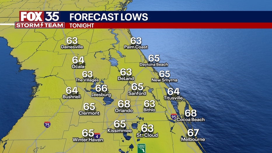
FOX 35 Storm Team Meteorologist gives us a look at what to expect for our weather Saturday night in Central Florida, as well as what's on the way for the next few days. Passing clouds will stick around for the rest of the evening with mostly clear skies and warm temperatures. Temperatures will be mild, and conditions will be humid tonight. Lows are expected to fall into the middle to upper 60s.
ORLANDO, Fla. - Passing clouds will stick around for the rest of the evening with mostly clear skies and warm temperatures in Central Florida.
Temperatures will be mild, and conditions will be humid tonight. Lows are expected to fall into the middle to upper 60s.
What will the weather look like the rest of the weekend?
What we know:
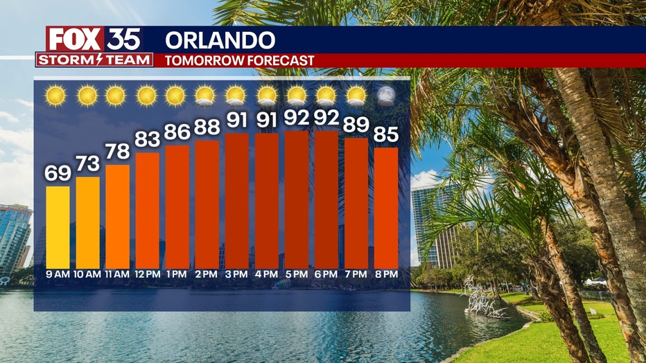
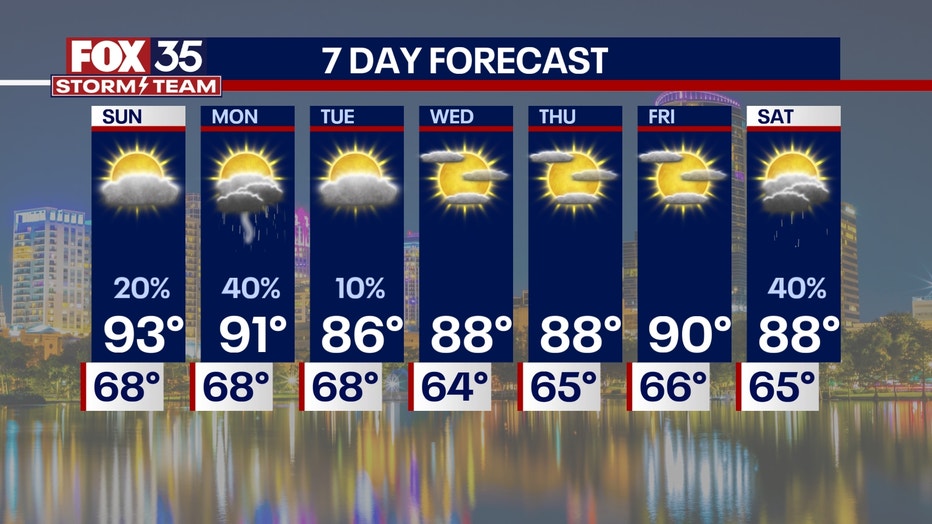
The weekend is going to continue to get hot. Temperatures will sizzle into the mid-90s on Sunday afternoon.
Overall, the rest of the weekend will feature strong sunshine, so make sure you stay hydrated and wear plenty of sunscreen. The UV index will be at 10.
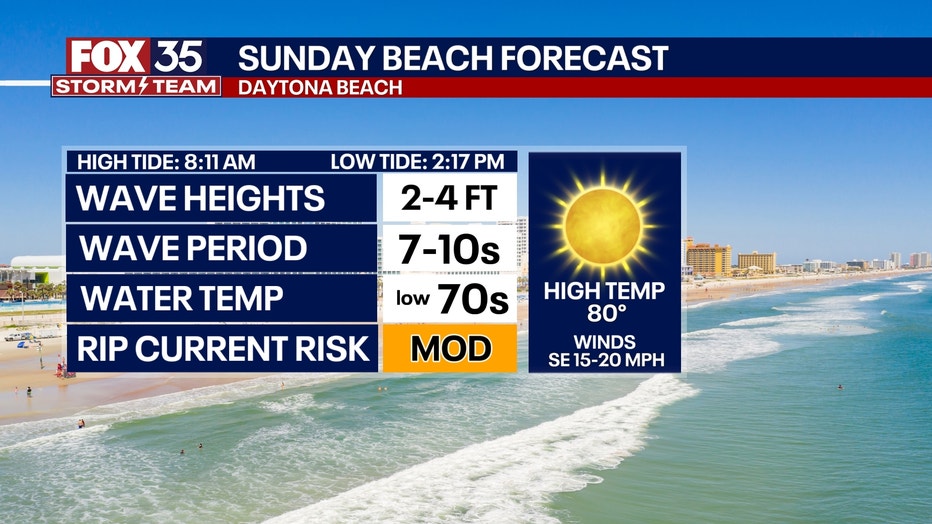
The heat will make a great beach day, but make sure you are careful in the water or swim close to a lifeguard, as rip currents will be moderate to high all weekend long.
Could rain be on the way?
What's next:
Although the rest of the weekend will stay hot, sunny and dry, there is a slight chance of rain finally back in our future.
The sea breeze storms will start up in the late afternoon. When the sea breezes collide, showers and isolated thunderstorms will pop up along the Interstate 75 corridor and Florida turnpike.
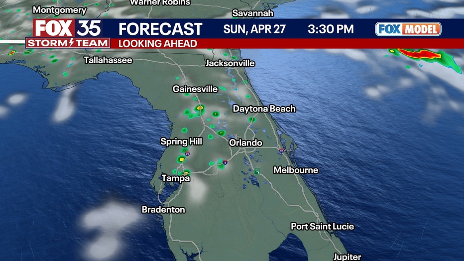
The showers won't be widespread, so the majority of the region will stay dry.
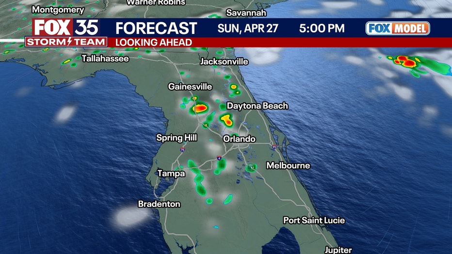
These storms should fade away on Sunday night as we lose that daytime-driven instability. A cold front could start to dip down into the peninsula and will bring some clouds and some cooler air into the region to start off the work week. A lingering shower or two is possible though with lows near 70 degrees.
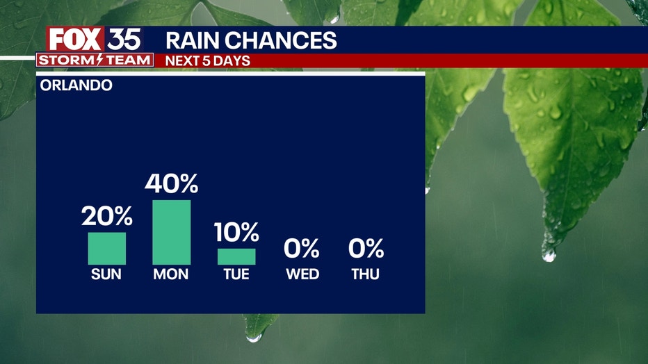
More scattered storms will pop up on Monday afternoon with a 30% chance of showers and thunderstorms.
The cold front that will slowly move through the region will allow for more widespread storms than what we saw on Sunday.
However, it won't be a washout of a day, but storms are expected on Monday afternoon and evening.
Some storms could again pack a little bit of a punch.
Drought continues, sparking fire possibility
Why you should care:
We desperately need rain. However, just this one day of showers will not fix the current extreme drought conditions in the region.
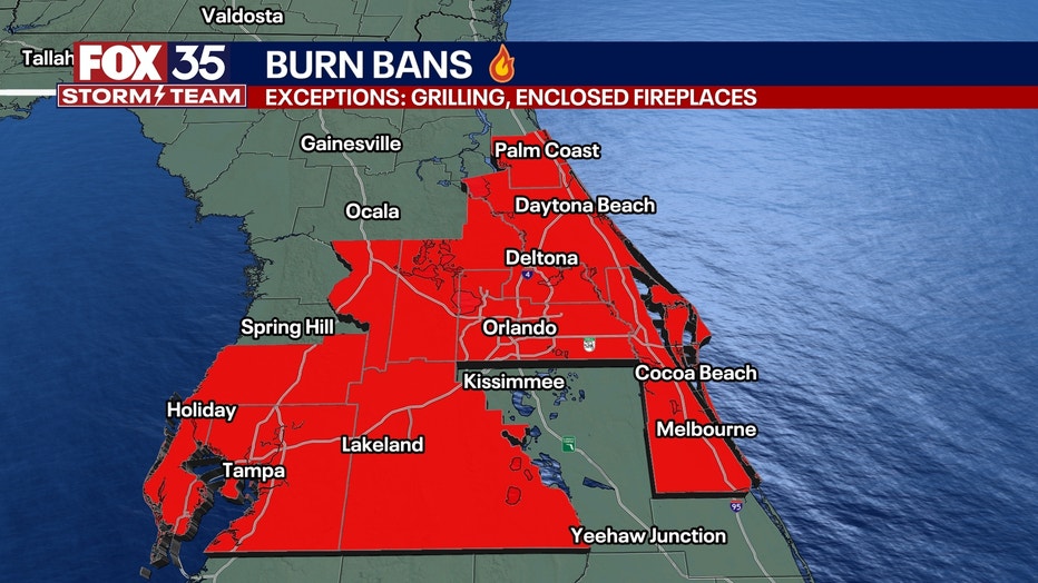
Burn bans are in place for nearly the entire Central Florida region.
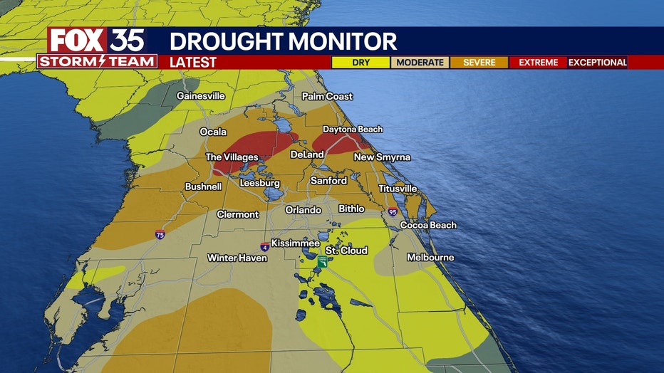
The concern is that if there is a lot of lightning with the possible thunderstorms that pop up from the sea breezes colliding, it could spark a new fire because it is so dry.
What will the weather look like next week?
Dig deeper:
Around the middle of next week, we will see more of a pattern change.
This means much higher chances of beneficial rain will be on the way, with multiple rounds possible.
Temperatures will be in the 80s through the start of the week.
However, the "cool down" does not last long.
High pressure builds in once again with temperatures back on the rise into the middle and back half of the workweek.
Highs are back into the lower 90s by Thursday and Friday.
FOX 35 Storm Tracker Radar and Live Weather Cameras
Track live when storms move across your area using the FOX 35 Storm Tracker Radar below. You can also watch as heavy rain moves across Central Florida on our Live Weather Cameras' page here.

More radar maps from FOX 35 Storm Tracker Radar
- Brevard County
- Flagler County
- Marion County
- Osceola County
- Orange County
- Polk County
- Seminole County
- Sumter County
- Volusia County
- U.S./National Radar
Stay connected with FOX 35
- Download the FOX 35 News app for latest news, weather, and traffic alerts
- Download the FOX 35 Storm Team Weather app for live, interactive radar
- Visit FOX35Orlando.com/weather for interactive radar, plus updated weather graphics, maps, and images
The Source: This story was written based on information shared by the FOX 35 Storm Team on April 26, 2025.