

Ida weakens into tropical storm as it pushes through southern U.S.
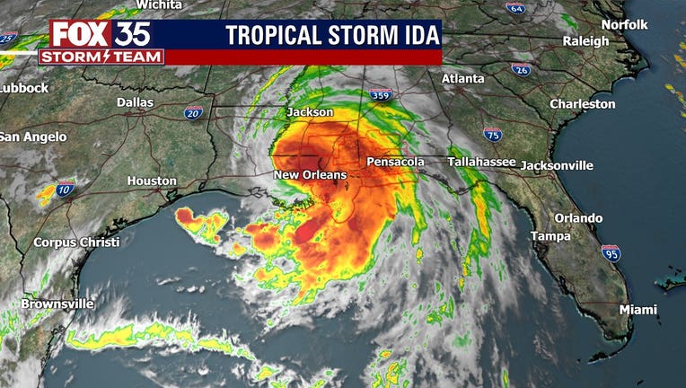
ORLANDO, Fla. - Ida made landfall as a dangerous Category 4 hurricane along the Louisiana coast on Sunday afternoon.
FOX 35 Storm Team Meteorologist Allison Gargaro said that the hurricane began to make landfall west of Grand Isle near Port Fourchon just before 1 p.m. EST.
Ida reportedly had maximum sustained winds of 150 mph, the National Hurricane Center (NHC) said. That is just 7 mph short of Category 5 hurricane status.
At around 7 p.m. EST, Ida was downgraded to a Category 3 hurricane with maximum sustained winds of about 125 mph. An hour later, the NHC said the storm had 120 mph maximum sustained winds.
At 10 p.m. EST, the NHC downgraded Ida to a Category 2 storm with maximum sustained winds at 105 mph.
The NHC said rapid weakening would continue as the storm continues moving north-northwest through Louisiana into Monday.
Hurricane Ida is bringing life-threatening storm surge, potentially catastrophic wind damage and flooding rainfall to the region.
TRACK THE TROPICS: Visit the FOX 35 Storm Team Hurricane Center for the latest tropical weather outlook and more
Tornadoes will also be possible Sunday into Monday from southeast Louisiana across southeast Mississippi and southwest Alabama to the western Florida Panhandle.
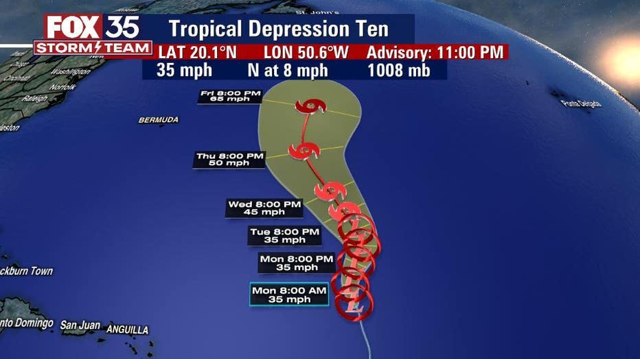
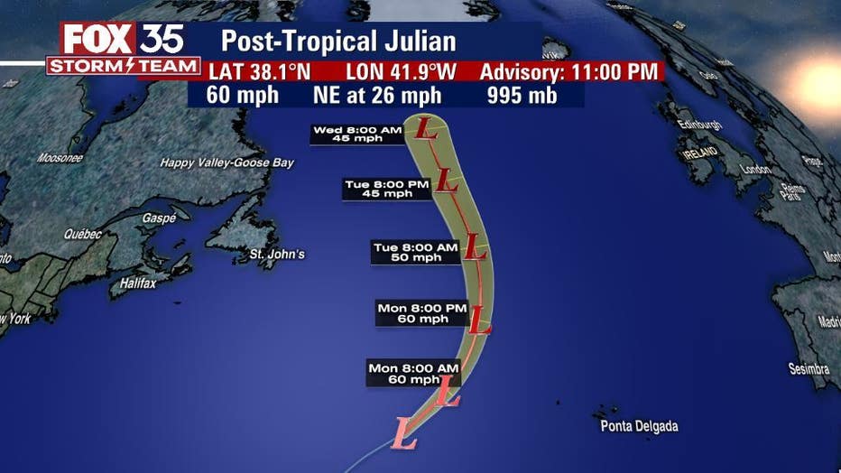
Meanwhile, the FOX 35 Storm Team is monitoring five systems in the tropics.
There is Hurricane Ida, Post-Tropical Julian, Tropical Depression 10 and two other disturbances to watch.
The NHC said that Tropical Depression 10 is moving north at 8 mph. Maximum sustained winds are said to be at 35 mph with little change in strength forecasted over the next couple of days. The depression could become a tropical storm by Tuesday or Wednesday. If it does, it will be called "Kate."
Post-Tropical Julian formed about 1,115 miles west of the Azores. It is moving northeast at 26 mph, forecasters said. It is expected to pick up some speed while moving northeast. Maximum sustained winds are said to be near 60 mph with some additional strengthening forecasted through Sunday night. Weakening should begin Monday with Julian becoming post-tropical by evening.
There is reportedly also a disturbance located just east of the Delmarva Peninsula and it is producing a few disorganized showers and thunderstorms over the warm Gulf Stream waters. The development of the system is expected to be slow, with just a 10% chance of formation over the next two to five days.
WEATHER ALERTS: Download the FOX 35 Storm Team Weather app for live radar, severe weather alerts, and daily forecast reports on your phone
The NHC said that a tropical wave expected to emerge off the coast of West Africa has a stronger chance for development. It should emerge off the continent’s coast by Tuesday, and environmental conditions are conducive for development once the wave moves offshore. A tropical depression is likely to form toward the end of the week while the system moves west-northwestward at 10 to 15 mph. It has a 30% chance of formation over the next two days, but it has an 80% chance over the next five days.
Watch FOX 35 Orlando for the latest Central Florida news.