


Noah Bergren
Noah joined the FOX 35 Storm Team in October 2023. Noah is originally from central Connecticut, and received his Bachelor of Science degree in atmospheric science and meteorology from Penn State.
Noah is a huge Nittany Lions fan, and tries to attend at least one home game in Happy Valley each season. He is also a very big New York Giants fan. He enjoys spending time with family and friends, having a good time, fishing, golf, and, of course, the weather.
Noah previously spent five and a half years as a meteorologist at WPSD Local 6, the NBC affiliate in Paducah, covering western Kentucky, southern Illinois, southeast Missouri, and northwest Tennessee. It was here Noah covered dozens of severe weather events and outbreaks, including the historic and deadly December 10th, 2021 EF-4 tornado that tore a 160+ mile continuous path across the coverage area. Rated as a 190 MPH tornado, it is one of the longest and strongest tornadoes in American-recorded meteorological history.
Noah was nominated for an Emmy Award for his coverage during the Dec. 10, 2021 tornado event. He's also a member of the American Meteorological Society and National Weather Association.
Noah loves to connect with viewers and talk about weather all the time, and would love to see your weather reports and photos on his social media pages.
The latest from Noah Bergren
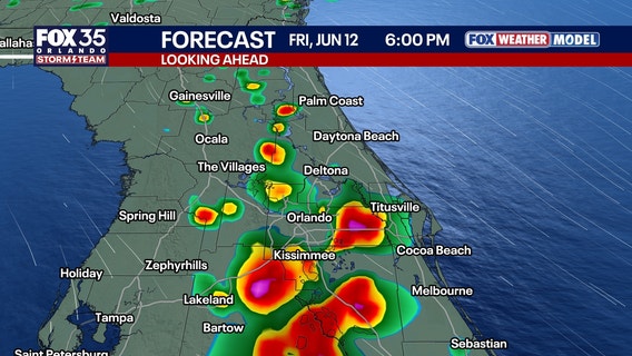

Orlando weather: Strong storms possible for Friday as heat, humidity builds
Scattered showers and thunderstorms moving through Central Florida on Thursday evening are expected to diminish.


Orlando weather: Rare June cooldown settles into Central Florida
A highly unusual June cold front is pushing through Central Florida, dropping afternoon highs into the low 80s and triggering gusty winds up to 35 mph.


Orlando weather: Timeline of storms expected this evening for parts of Central Florida
There is a possible severe storm threat for Orlando and Central Florida on Tuesday night. Here's live forecast updates, weather alerts and warnings, and the storm timeline.


Florida rainfall forecast: Tropical moisture pushes into Central Florida
Clouds building into mid-morning will quickly deliver localized downpours, before numerous storms develop this afternoon and move east across Central Florida.


Tropical development over Florida? Pattern shift expected to bring heavy rain, summer humidity
Central Florida has had an appetizer of the rainy season, but has not yet officially gotten into the rainy season for 2026.


Orlando weather: Humidity peaks with heat index values over 100°F
Central Florida is bracing for a notable surge in humidity heading into Memorial Day weekend, driving afternoon heat index values toward 100°F despite standard high temperatures holding steady in the low 90s.


Orlando weather: Highs near 90s; rain possible for Memorial Day weekend
Tonight will feature hot and increasingly humid conditions across Central Florida. Aside from a very isolated evening thundershower, most neighborhoods will stay completely dry. Expect partly cloudy skies overnight as low temperatures drop into the sticky low 70s.


Orlando weather: Pleasant overnight conditions before hotter Friday, stormier weekend
Friday stays mostly dry, warmer and a bit more humid with highs near 90 degrees.


Orlando weather: Lingering showers possible overnight, with mostly sunny, hot Saturday ahead
There is the potential for some storms on Friday evening.