Orlando weather: Sunny skies to start to the weekend before storm chances return

Orlando PM Weather Forecast: October 25, 2025
Meteorologist Laurel Blanchard has the breakdown on Melissa as well as multiple cold fronts that'll impact Central Florida. Tune in to see when the rain chances return with those fronts and how cool we'll get.
ORLANDO, Fla. - We're kicking off the weekend on a beautiful note as high pressure continues to keep its hold over Central Florida. Sunshine prevails with just a few clouds from time to time. With this ridge in control, temperatures start to come up a bit, but it'll be seasonable.
What will the weather look like tonight?
What to Expect:
Expect highs to top out in the middle 80s inland with readings a touch cooler near the coast, thanks to the onshore flow. Overnight, clouds do start to thicken a bit as a warm front begins to lift northward. It won't be quite as cool, as lows dip to near 70 in the metro.
What will the weather look like tomorrow?
What to Expect:
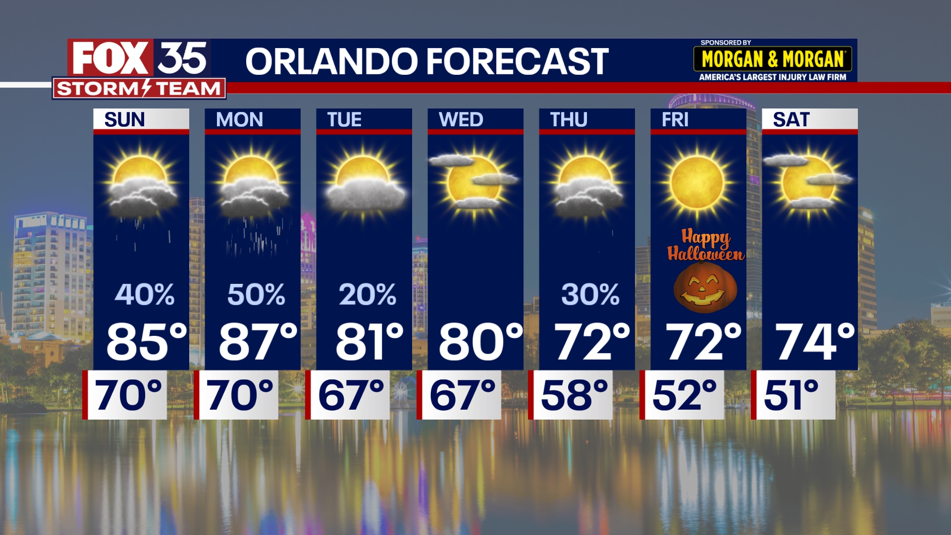
Changes unfold on Sunday with this warm front draped across the viewing area. That'll make for hit-or-miss showers and storms during the afternoon and evening. With more moisture in the air, we'll have the threat of downpours as we'll have some gusty wind in any strong storm that develops.
It won't be a washout, but you'll certainly want the rain gear for the afternoon...just in case. It'll also be noticeably more humid with the SE flow.
Dew points get back into the lower 70s with highs rising back into the middle to upper 80s. The chance for showers and storms holds into Sunday night as our next storm system continues to move our way.
Looking ahead
What to Expect:

A cold front will be on the move on Monday and that'll keep the threat for showers and storms around. Once again, Monday won't be completely water-logged, but we can expect scattered showers and storms throughout the day.
A couple of stronger storms with frequent lightning and gusty wind will be possible as well. On the backside of this cold front, we'll feel a solid cool-down as well as a nice shot of refreshing air. Highs into midweek drop into the lower 80s with dew points back into the upper 50s and lower 60s. A secondary cold front moves our way late Wednesday into Thursday and this one brings the potential for a few showers and storms.
Behind it, the biggest cool-down of the season is on tap. Highs fall into the lower to middle 70s with lows in the 50s. Some outlying spots to the NW may fall into the 40s! It'll be a crisp Halloween!
Tracking Melissa

Melissa will undergo rapid intensification over the next 48 hours.
The lack of wind shear and extreme warmth in the Caribbean will allow this strengthening to unfold. It could come close to Cat. 5 status if it does not become a Category 5 storm Monday. This is when it could make devastating landfall in Jamaica with catastrophic flooding and landslides on the table.
Hurricane Warnings are now in place for Jamaica with Hurricane Watches for parts of Haiti. We'll deal with the indirect impacts here at home early next week with life-threatening rip currents and big surf as well as coastal erosion.
The Source: This story was written based off information shared by the FOX 35 Storm Team on Oct. 25, 2025.

