

Cold front incoming, but first? Summer's last showers and storms

Weather Report: September 19, 2021
FOX 35 Storm Team Meteorologist Allison Gargaro gives the latest on the weather in Central Florida.
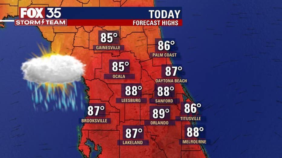
ORLANDO, Fla. - This is the last official weekend of summer and it is feeling like it.
Afternoon highs across Central Florida will reach the upper-80s with humid conditions.

MORE NEWS: Tropical Storm Peter and Tropical Depression 17 form overnight
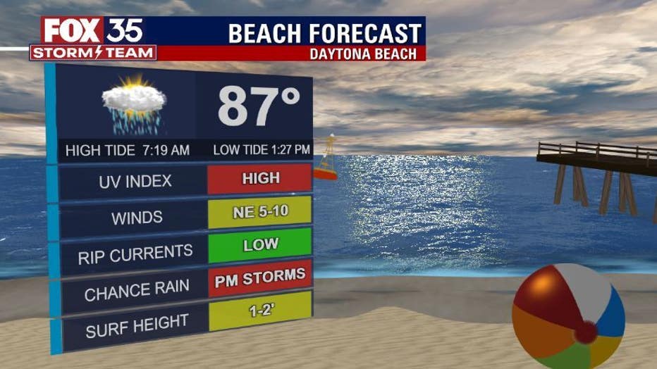
By the mid-morning hours, there will be an increase in clouds. Then, by 2 or 3 p.m., the sea breeze storms will begin to initiate and collide across the center of the peninsula around 7 p.m.
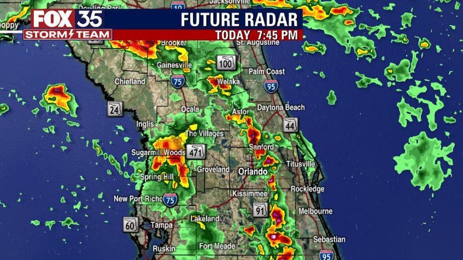
Heavy downpours of two to four inches are likely, leading to localized flooding. There is also a chance for frequent cloud-to-ground lightning and gusty winds.
WEATHER ALERTS: Download the FOX 35 Storm Team Weather app for live radar, severe weather alerts, and daily forecast reports on your phone
There is an influence of tropical moisture across the region, meaning that rain and storm chances stay high each afternoon through the middle of this week.
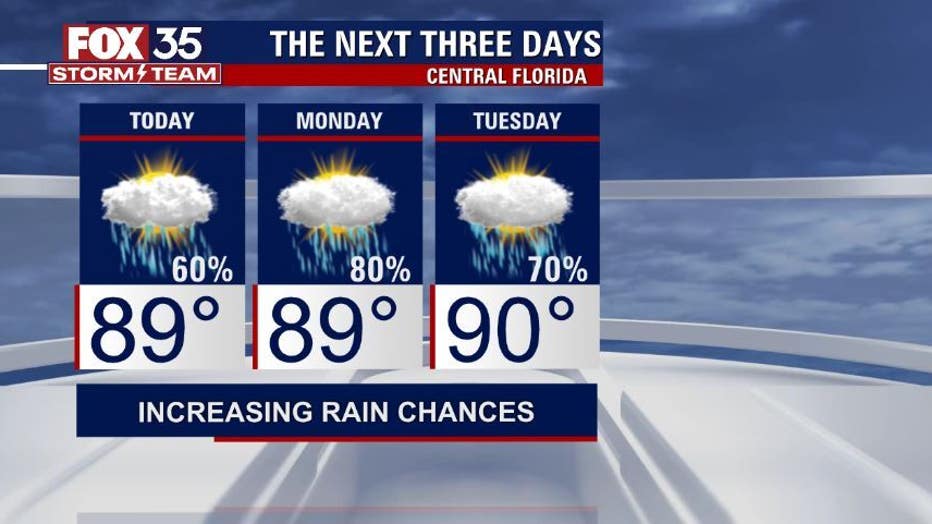
By Thursday or Friday, a cold front will be sweeping across the southeast. On the back end of the front, cities will see slightly cooler and drier air.
TRACK THE TROPICS: Visit the FOX 35 Storm Team Hurricane Center for the latest tropical weather outlook and more
"Next Wednesday is the first day of autumn, and long-range computer models suggest we may indeed see our first noticeable cold front during the last week of September," said FOX 35 Storm Team Meteorologist Brooks Garner.
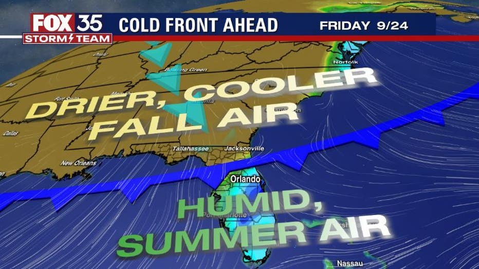
But don't get too excited. Forecasters said the cooldown will be short-lived.
"In about two weeks, drier air may surge south allowing overnight temps to fall into the 50s and low-60s, followed by highs in the mid-80s," Garner explained. "It's not going to be jacket weather [during the daytime] but it's certainly going to feel a lot better if you're tired of this tropical humidity."
MORE NEWS: With Gabby Petito still missing, search resumes in Florida for Brian Laundrie
Astronomically speaking, autumn begins on September 22.
Many newcomers to Florida often want to know when do cooler temperatures typically arrive after our brutal summer heat.
According to the National Weather Service (NWS), most of Central Florida experiences some short-lived cooler air in mid-October, lasting only a day or two. For the most part, it takes until November before low temperatures fall into the mid-50s north to lower 60s south on a consistent basis.
Watch as the FOX 35 Storm Team monitors conditions closely and tracks how our rain chances will be impacted for next weekend.