

Orlando weather forecast: Cold front to drop temperatures into the 50s in Central Florida

Weather Forecast: Oct. 4, 2022
Orlando and Central Florida will experience high temperatures in the mid-to-upper 80s over the next several days. It will be drier too, with the earliest chance for precipitation arriving around Tuesday.
ORLANDO, Fla. - Tonight's low: 62 degrees | Tomorrow's high: 81 degrees | Rain: 0%
Main weather concerns: Another dry day for the area with the exception along the Brevard County coast, where a few showers are possible. Skies will feature a mix of sun and clouds. Winds trend breezy from the north as a weak front slides through the area. High temps are comfy today, around 80 or so.

Lows tonight dip into the 50s and 60s across the viewing area. Flood issues continue in the middle of St. Johns River through midweek above Lake Harney, near Deland, and at Astor.

BEACHES:
The beaches will feature breezy-windy conditions as northerly winds crank up today. Highs reside in the upper 70s. Rip current risk remains elevated. Surf is in the 2-3 feet range in the north wind swell.
A few showers will possible blow by in the increased wind flow. Coverage along the beaches stands at 20%.
OUTLOOK:
The extended outlook for Central Florida weather looks great. Dry skies and sunshine can be expected at most times. The longer-term forecast calls for a few showers around by the late weekend into early next week.
TROPICS:
The tropics remain relatively quiet in the wake of IAN. The FOX 35 STORM TEAM continues tracking two distant areas of disturbed weather. Disturbance #1 will approach the Eastern Caribbean Islands this weekend with low chances for development. This feature looks to stay over the Southern Caribbean longer term, heading closer to Central America.
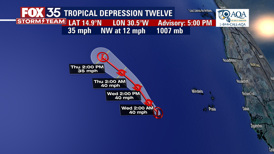

Disturbance #2 was upgraded on Tuesday into a Tropical Depression but it stays well east of any land and has a high chance of developing over the next five days. We're tracking for you as always!