

Orlando Weather Forecast: Cooler temperatures on the way after near-record heat in many places

Orlando Weather Forecast: Nov. 15, 2022
FOX 35 meteorologist Brooks Garner has a look at the forecast.
Today's high: 87 degrees | Tonight's low: 68 degrees | Rain: Mainly dry
Main weather concerns: Another day of mixed skies and rather warm temps. Looks like temps come in a bit warmer than yesterday, some areas could approach or break existing daily high temp records this afternoon. Southerly breezes and lacking rain opportunities will allow afternoon temps to rise into the mid-upper 80s. Best record breaking or tie potential will be in Leesburg and Orlando. Leesburg forecast high stand at 86, the record is 85 set in 2020. Orlando's forecast high stands at 87, record there is 88 set back in 1957.

BEACHES: The beaches feature a mix of sun and clouds, highs in the low-80s. A moderate risk of rip currents remains in place for the local surf zone. Surf is in the 2-4' range as a new NE swell arrives today. Surf looks fun with light SW winds for much of the day, get wet if you can!
THEME PARKS: Decent day for the theme parks on this Tuesday. High temp this pm heads for the mid-upper 80s under a mix of sun and clouds. Skies stay dry.
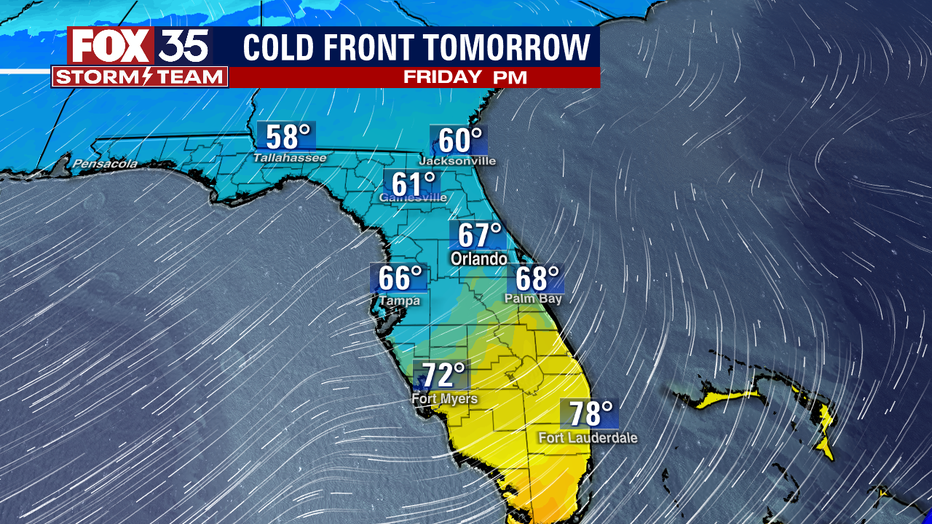
OUTLOOK: Midweek front brings colder temps. Highs late week reside in the mid-upper 60s and low fall closer to 50 degrees, perhaps some 40s for the Northern Counties. Some light showers will accompany the front on late Tuesday night into early Wednesday. Ocean blown showers and Northeast breezes dominate next weekend with highs around 70, lows down in the 50s.


TROPICS: The tropics are calm with no activity expected within the next five days. The hurricane season continues until November 30th.