

Orlando weather: Temps climb to near 80s in Central Florida ahead of midweek cold front

Orlando Weather Forecast: March 25, 2024
High will reach into the 80s on Tuesday with increasing clouds. Our next chance for rain will be on Wednesday.
ORLANDO, Fla. - Monday night into Tuesday morning, we will see partly to mostly cloudy skies with low temperatures in the 60s. Despite all the clouds on Tuesday, highs should be getting into the middle 80s.
With spring break for Volusia and Brevard counties, it's essential to remember that if you have beach plans, potentially deadly rip currents will be commonplace on our Atlantic beaches, with 7-foot breaking waves and a steady east wind of 25 to 30 mph.
BEACH FORECAST: Dangerous swimming weather is expected over the next few days. There is high surf and a high risk of rip currents through Thursday.
THEME PARK FORECAST: Bring rain gear if you're going to the theme parks on Wednesday or Thursday. Otherwise, it should be great through the weekend.
LONG RANGE INTO NEXT WEEK: Starting on Tuesday and through midweek, we'll warm into the mid-80s ahead of our next front. The approaching cold front is weak, resulting in only a few showers on Thursday.
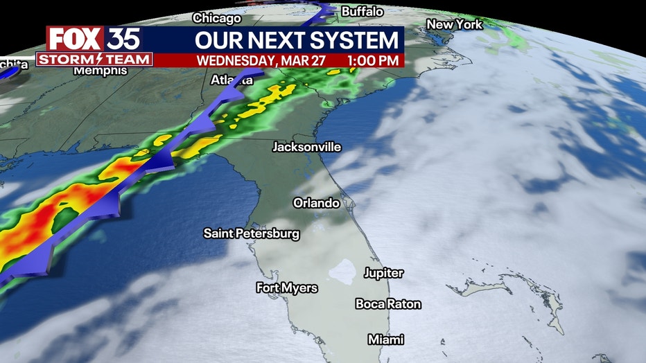
A cold front will impact Florida from Wednesday into Thursday. Showers and non-severe storms will start in the panhandle in Northwestern Florida on Wednesday and slowly spread toward central Florida from late Wednesday into Thursday morning.
Rains will not be heavy in central Florida, but Gainesville and points north from there could receive over half an inch to an inch of rain with the system. For example, areas around Orlando probably stay under a quarter of an inch of rain.
Thursday starts cloudy and showery, then the cold front comes through, and it rapidly clears in the afternoon and evening. Friday, Saturday, and Sunday will be beautifully bright, sunny, and awesome! Humidity will be low, with lots of sunshine and lighter winds.
Don’t forget that two weeks from today is the solar eclipse, during which 50 to 60% of the sun will be blocked in central Florida as it crosses the United States!