

Orlando weather: Severe weather threat continues for Central Florida

Orlando Weather Forecast PM: May 9th, 2025
FOX 35 Storm Team Meteorologist Noah Bergren is tracking more rain, storms, and active weather through Monday!
ORLANDO, Fla. - Strong thunderstorms rolled across Central Florida on Friday evening, triggering delays at Orlando International Airport and dumping several inches of rain in some areas. Most of the severe weather has passed, though a few storms could pop up in coastal counties.
Severe weather threat continues for Central Florida
What to expect:
The region should brace for a busy stretch of stormy weather through the weekend, including on Mother’s Day, with the possibility of hail, damaging winds, and heavy downpours. Monday could bring an even higher chance of severe weather, according to the FOX 35 Storm Team.
Highs remain in the 90s with stifling humidity. A drier, hotter pattern is expected to return by late next week.
Lingering showers and non-severe weather continue into Friday evening. Any storm that intensifies could bring large hail, damaging wind gusts, and heavy rainfall. However, the potential for severe weather is diminishing.
By early evening, heavy rainfall had soaked areas west and east of the metro, with storm activity intensifying in central parts of the state. Port St. John saw more than two inches of rain in an hour, and parts of Mims recorded five inches, prompting minor flooding.
Around 6:30 p.m., the Federal Aviation Administration (FAA) issued a ground stop at Orlando International, delaying inbound flights. A ground stop was extended to 9 p.m. causing flight delays
Weekend weather forecast for Orlando area
What to expect:
Saturday has been declared a FOX 35 Weather Impact Day. Scattered afternoon and evening storms may become strong to severe, with risks of hail, damaging winds, and localized downpours.
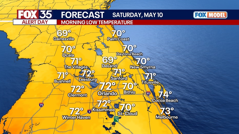
Lows on Saturday morning will dip into the low 70s across most of the region.
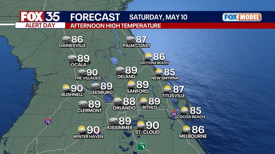
Highs on Saturday will reach the 80s with elevated humidity.
What will the weather be like on Mother's Day in Orlando?
What to expect:
Sunday is also a FOX 35 Weather Impact Day. For any Mother's Day plans, the morning looks to be on the dry side. The afternoon poses a higher chance of severe storms, including brief tornadoes, strong winds, and hail—especially during the afternoon and evening hours.
What will the weather look like next week?
Looking ahead:
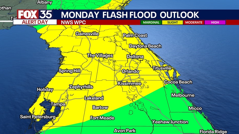
Monday is a FOX 35 Weather Impact Day, but it could be upgraded to a FOX 35 Storm Alert Day as confidence grows in a widespread severe threat. Forecasters say storms may bring elevated risks of tornadoes and damaging winds across parts of the state, though exact locations remain uncertain.
A low-pressure looks to develop over the Gulf into early next week. This system is expected to bring additional moisture into the region, enhancing the likelihood of showers and storms.
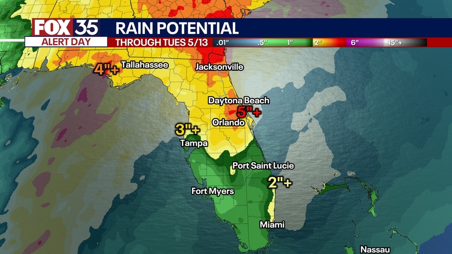
Heavy rain will be a safe bet for Monday afternoon, evening, and then into early Tuesday morning. The potential of a few strong storms exists during this same timeframe as well.
Relief is expected later next week, as drier, sunnier, and hotter weather returns to the region.
Be sure to stay close to the forecast and FOX 35 Storm team for the latest updates on our rain and storm chances in the coming days.
Orlando 7-Day Weather Forecast

FOX 35 Storm Tracker Radar
Track live when storms move across your area using the FOX 35 Storm Tracker Radar below.

More radar maps from FOX 35 Storm Tracker Radar
- Brevard County
- Flagler County
- Lake County
- Marion County
- Osceola County
- Orange County
- Polk County
- Seminole County
- Sumter County
- Volusia County
- U.S./National Radar
Stay connected with FOX 35
- Download the FOX 35 News app for latest news, weather, and traffic alerts
- Download the FOX 35 Storm Team Weather app for live, interactive radar
- Visit FOX35Orlando.com/weather for interactive radar, plus updated weather graphics, maps, and images
The Source: This story was written based on information shared by the FOX 35 Storm Team on May 9, 2025.