

Orlando weather: Daily storms and flooding threat possible through July 4th weekend

Orlando Weather Forecast PM: July 30, 2025
FOX 35 meteorologist Noah Bergren has a look at the weather forecast for Orlando and Central Florida for July 30, 2025.
ORLANDO, Fla. - Daily afternoon storms will continue throughout the week and into the July 4th holiday weekend.
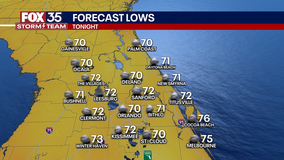
What will the weather look like tonight?
What to Expect:
It will be mostly cloudy with a few passing thundershowers any time of night. Temperatures will dip into the lower 70s.
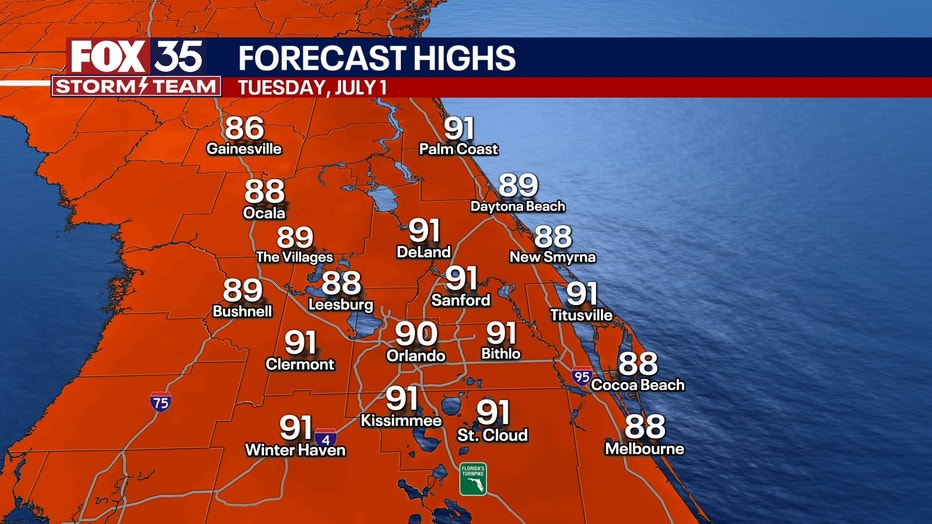
What will the weather look like on Tuesday?
What to Expect:
There will be a mix of clouds and sunshine with scattered showers and storms mainly in the afternoon and evening. Showers and storms gradually wind down after sunset.
Temperatures will be warm and muggy overnight as lows fall into the low and mid 70s.
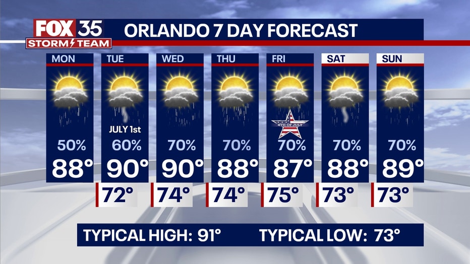
What will the weather look like the rest of the week?
What to Expect:
Daily rounds of afternoon showers and storms are on the way for this week and into the holiday weekend. An incoming front will gradually stall out over the region towards the end of the week.
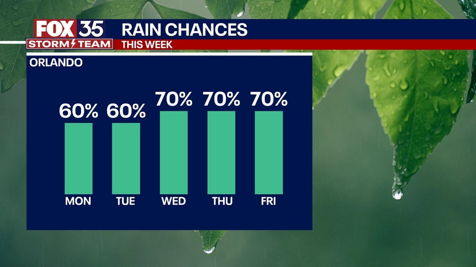
This, coupled with tropical moisture and Atlantic sea-breeze collision, will bring multiple rounds of showers and storms, many of which bring the chance of very heavy rainfall and the risk of flooding.
Stay close to the forecast for your Independence Day celebrations and plans! Temperatures this week will likely stay below normal, with afternoon highs only reaching the upper 80s and around 90 degrees at best into the weekend.
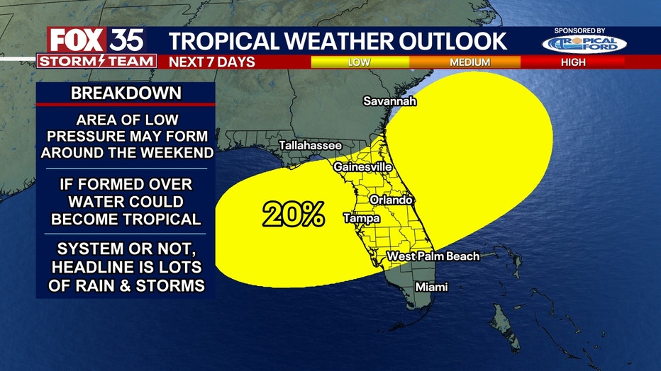
Tracking the Tropics
What to Expect:
There's an area of interest that's been outlined by the NHC for potential tropical development in the Gulf stretching across Central Florida and into the Atlantic. There is only a low 20% chance of development, as we are still several days out.
The fading cold front that's set to dip into the southeast will stall out across the Florida peninsula. As this takes shape, an area of low pressure may try to form along the remnants of this front. This could, at most, lead to a low chance of a tropical depression forming.
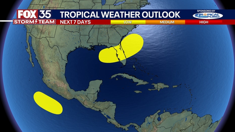
Regardless of whether a depression forms or not, heavy and potentially flooding rainfall will be the biggest impact felt during the holiday weekend.
Be sure to stay with the FOX 35 Storm Team for the latest on this system in the coming days.
FOX 35 Storm Tracker Radar and Live Weather Cameras
Track live when storms move across your area using the FOX 35 Storm Tracker Radar below. You can also watch as heavy rain moves across Central Florida on our Live Weather Cameras' page here.
More radar maps from FOX 35 Storm Tracker Radar
- Brevard County
- Flagler County
- Lake County
- Marion County
- Osceola County
- Orange County
- Polk County
- Seminole County
- Sumter County
- Volusia County
- U.S./National Radar
STAY CONNECTED WITH FOX 35 ORLANDO:
- Download the FOX 35 News app for breaking news alerts, the latest news headlines
- Download the FOX 35 Storm Team Weather app for weather alerts & radar
- Sign up for FOX 35's daily newsletter for the latest morning headlines
- FOX Local: Stream FOX 35 newscasts, FOX 35 News+, Central Florida Eats on your smart TV
The Source: This story was written based on information shared by the FOX 35 Storm Team on June 30, 2025.