

NHC: Tropical Storm Bonnie 'likely' to form, 2 other systems being monitored

Tracking the Tropics: June 29, 2022
FOX 35 Storm Team Meteorologist Brooks Garner has the latest tropical activity in the Atlantic Ocean and the Gulf of Mexico.
ORLANDO, Fla. - There are three systems in the tropics being watched by forecasters with the National Hurricane Center.
The first, Potential Tropical System #2, is expected to become a tropical depression within the next day or so. On Wednesday afternoon, the center of this system was located about 181 miles (285 km) east-southeast of Guajira Peninsula, Colombia with maximum sustained winds of 40 mph (65 kph). Tropical-storm-force winds extend outward up to 60 miles (95 km) from the center.
"Conditions appear conducive for development if the disturbance remains over water, and it will likely become a tropical storm near the southern Windward Islands or while moving westward across the southern Caribbean Sea," the National Hurricane Center said Tuesday. If it does become a tropical storm, it would be named Bonnie.
A Hurricane Watch is in effect for:
- Nicaragua/Costa Rica border to Laguna de Perlas Nicaragua
A Tropical Storm Warning is in effect for:
- Bonaire
- Curacao
- Aruba
- Coast of Venezuela from the Peninsula de Paraguana westward to the Colombia/Venezuela border including the Gulf of Venezuela
- Coast of Colombia from the Colombia/Venezuela border westward to Santa Marta
A Tropical Storm Watch is in effect for:
- Limon Costa Rica northward to the Nicaragua/Costa Rica border
- North of Laguna de Perlas to Sandy Bay Sirpi Nicaragua
The system is moving toward the west near 21 mph (33 km/h). On the forecast track, the system will pass near the southern Caribbean Sea and the northern coast of Venezuela tonight, near the Guajira Peninsula of Colombia early Thursday, and over the southwestern Caribbean Sea later on Thursday and on Friday. The system is expected to be near or over Nicaragua by late Friday.
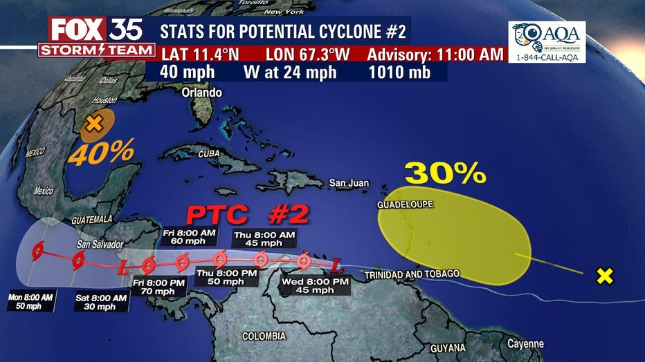
A second system being monitored is an area of disorganized showers and thunderstorms in the Gulf of Mexico. This area now has a 40% chance for further development. Showers and thunderstorms associated with this area of low pressure have increased. It is forecast to move slowly westward and approach the coast of southern Texas and northern Mexico by early Thursday.
DOWNLOAD: FOX 35 NEWS APP | FOX 35 STORM TEAM WEATHER APP
A third is a tropical wave with an area of disorganized showers and thunderstorms with a 30% formation chance within the next five days. Slow development of this system is possible while it moves west-northwestward for the next few days. The wave is forecast to move over the Windward Islands late Friday or early Saturday and then over the eastern Caribbean Sea by the weekend, where further development is unlikely due to unfavorable environmental conditions.
The National Oceanic and Atmospheric Administration (NOAA) predicts another above-average Atlantic hurricane season for the 2022 season, which runs June 1 - Nov. 30 – marking the seventh consecutive above-average hurricane season.
This season, NOAA anticipates between 14 and 21 named storms, and between 6-10 of those becoming hurricanes. Of those 10, NOAA said three to six could become major hurricanes (category 3, 4, or 5).
Stay with the FOX 35 Storm Team for the latest updates throughout hurricane season.