

Hurricane Ian: Timeline for storm's impact in Central Florida counties
As Hurricane Ian nears Central Florida, the FOX 35 Storm Team continues to track when the local area could see potential impacts.
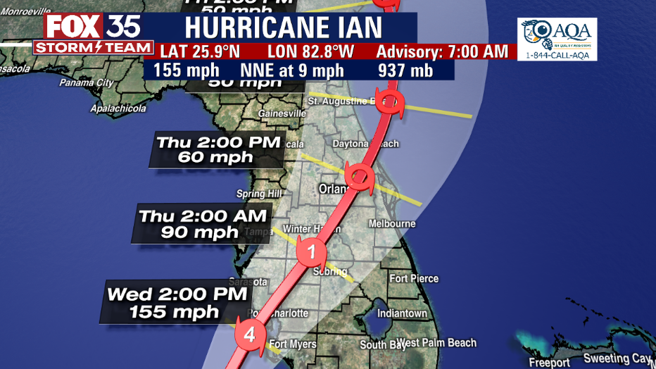
On Wednesday, Ian strengthened into a major Category 4 hurricane and is forecast to make landfall in Florida later in the day.
Overall, severe weather is likely across the Orlando metropolitan area up to North Central Florida, with local impacts including heavy rain, lightning, damaging winds, and the chance for isolated tornadoes.
Check to see the impacts your area could experience in the coming days below:
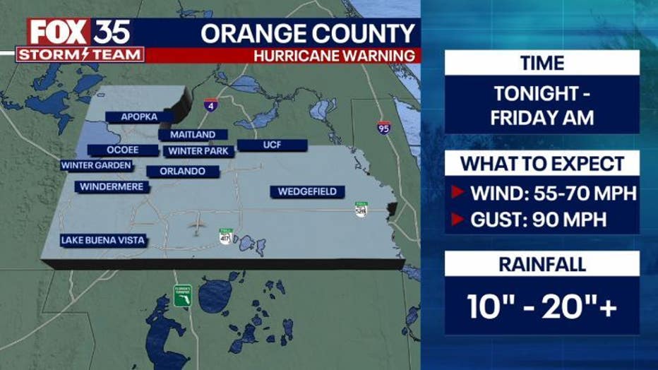
ORANGE COUNTY
Orange County residents can expect impacts Wednesday evening/night through Friday. Those impacts include 80 mph gusts and wind speeds of 55 to 70 mph. The area could see up to 10 to 20 inches of rainfall.
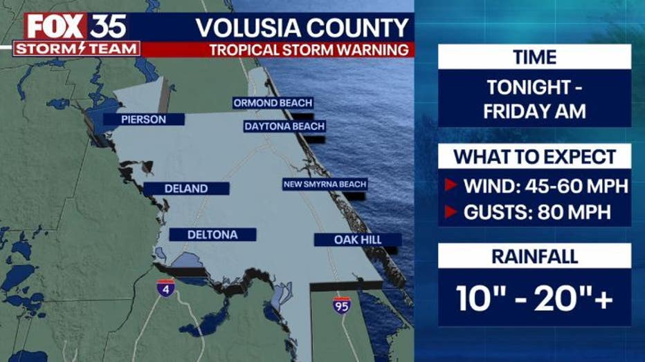
VOLUSIA COUNTY
Volusia County residents can expect impacts from Ian Wednesday evening/night through Friday. Those impacts include 80 mph gusts and wind speeds of 45 to 60 mph. The area could see up to 10 to 20 inches of rainfall.
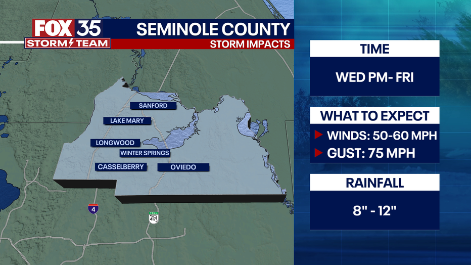
SEMINOLE COUNTY
The Seminole County area can expect to see 50 to 60 mph winds and 75 mph gusts Wednesday evening/night through Friday. Rainfall is forecast to be 8 to 12 inches.
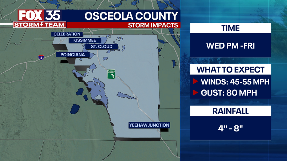
OSCEOLA COUNTY
Osceola County will see impacts Wednesday evening/night through Friday. Those impacts include 80 mph gusts and 45 to 55 mph winds. The county can expect to see 4 to 8 inches of rainfall.
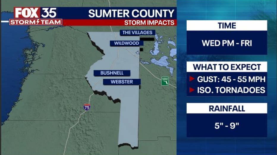
SUMTER COUNTY
Sumter County will see impacts Wednesday evening/night through Friday. Those impacts will include 45 to 55 mph gusts and the potential for isolated tornadoes. The county can expect to see 5 to 9 inches of rainfall.
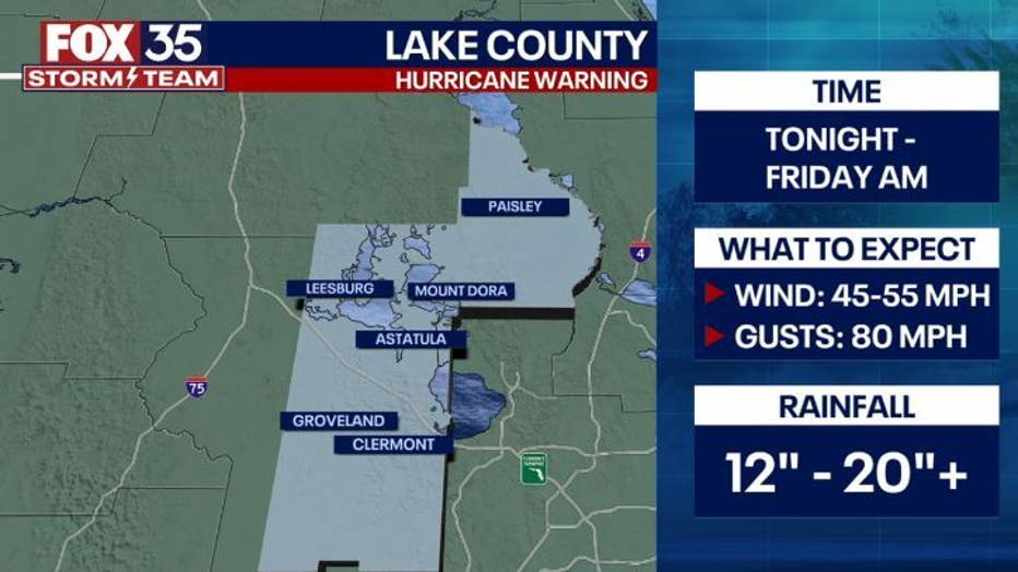
LAKE COUNTY
Lake County residents can expect 80 mph gusts, and 45 to 55 mph winds Wednesday evening/night through Friday. The area could see up to 12 to 20 inches of rainfall.
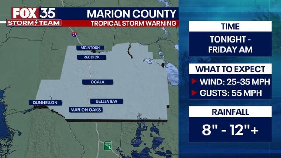
MARION COUNTY
Marion County can expect to see storm impacts Wednesday evening/night through Friday morning. Wind speeds between 25 and 35 mph are expected, as well as 55 mph gusts. Rainfall will be between 8 and 12+ inches.
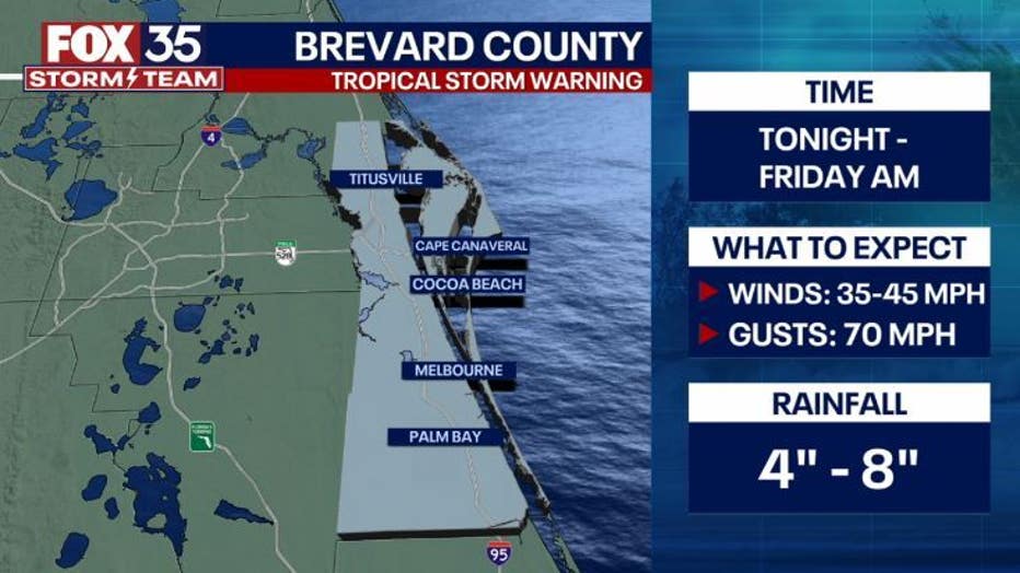
BREVARD COUNTY
The Brevard County area can expect to see 70 mph gusts and 35 to 45 mph winds Wednesday evening/night through Friday. Rainfall is forecast to be 4 to 8 inches.
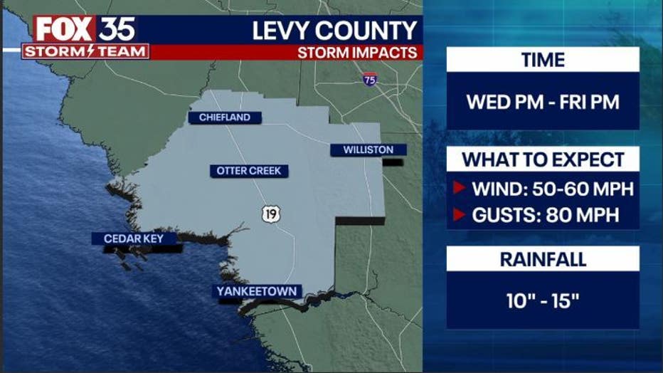
LEVY COUNTY
Between Wednesday evening/night through Friday evening/night, Levy County can expect 80 mph gusts and 50 to 60 mph winds. The area will see more than 10 to 15 inches of rainfall.
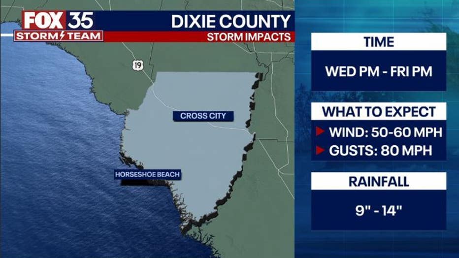
DIXIE COUNTY
Dixie County can expect to see storm impacts Wednesday evening/night through Friday night/evening. Gusts of 80 mph and wind speeds of 50 to 60 mph are expected. The area will seebetween 9 and 14 inches of rainfall.
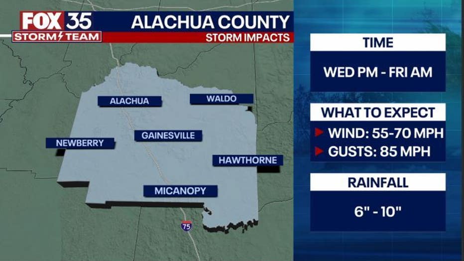
ALACHUA COUNTY
Alachua County can expect to see storm impacts Wednesday evening/night through Friday morning. Wind speeds between 55 and 70 mph are expected, as well as 85 mph. Rainfall will be between 6 and 10 inches.
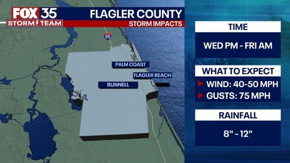
FLAGLER COUNTY
The Flagler County area can expect to see 40 to 50 mph winds and 75 mph gusts Wednesday evening/night through Friday morning. Rainfall is forecast to be 8 to 12 inches.
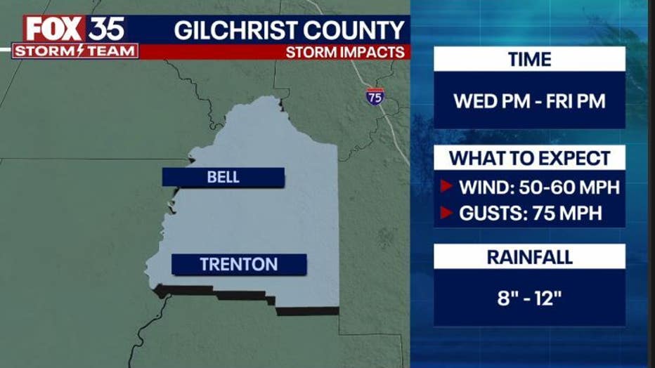
GILCHRIST COUNTY
Gilchrist County residents can expect to see winds between 50 and 60 mph and 75 mph gusts. Rainfall will be between 8 and 12 inches.
As new information is made available regarding the storm's track, we will update this story.