

Temperatures fall into the low 80's, below average for this time of year

Weather Report: September 21st
FOX 35 meteorologist Jayme King gives the latest on the weather in Central Florida.
ORLANDO, Fla. - Conditions are improving along the coast in Central Florida after a weekend of heavy rain and coastal flooding. Temperatures are now cooling down and the air is breezy.
The Central Florida coast saw flooding on Sunday due to a disturbance that moved inland, causing strong winds, heavy rain, and rough surf.

Heavy flooding in Volusia County during weekend storms
Roads and backyards in Volusia County flooded due to heavy rainfall over the weekend.
This disturbance has since gone out in the open Gulf of Mexico. It is located near South Florida and remains an area of low pressure. It has just a 20 percent chance of developing over the next five days. It will be a rainmaker for the southern portion of the peninsula.
With that, rain chances are much lower on Monday. Gusty winds remain but moisture levels have eased after Sunday's flood of rainfall.
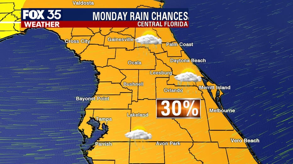
In addition, temperatures for this time of year are usually around 89 but with the gusty winds, temperatures are in the low 80s. This is below average for this time of year.
WEATHER ALERTS: Download the FOX 35 Weather App to track the tropics on your phone, receive severe weather alerts, and get the latest daily forecasts
Meanwhile, in the tropics, FOX 35 meteorologist Jayme King is tracking several systems.

Tracking the Tropics: September 21st
FOX 35 meteorologist Jayme King gives the latest in the tropics.
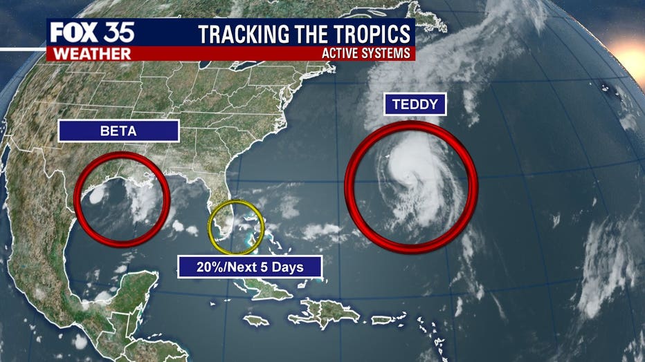
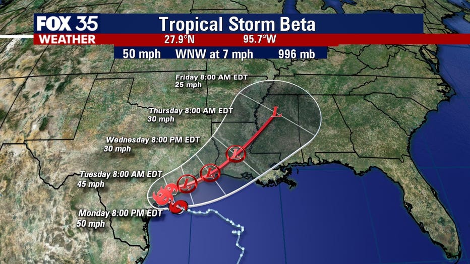
TROPICAL STORM BETA
Tropical Storm Beta is expected to produce tropical storm conditions over portions of the Texas coast on Monday night, the National Hurricane Center (NHC) said.
The storm is currently located about 55 miles east-southeast of Port O'Connor, Texas. It is moving west at 7 mph with maximum sustained winds of 50 mph.
Beta is forecasted to make landfall on the Texas Coast on Monday night. Once it begins to move inland, the NHC expects the storm to weaken.
HURRICANE TEDDY
Teddy is a large hurricane and is moving north, bringing along dangerous rip currents.
The Category 1 hurricane is currently about 150 miles east-southeast of Bermuda, moving north at 90 mph. It is said to have maximum sustained winds of 90 mph.
The NHC forecasts that Teddy will pass east of Bermuda on Monday and then go on to approach Nova Scotia on Wednesday. The hurricane has weakened into a Category 1 but is expected to pick strength back up overnight. However, by Wednesday, it should weaken more and become a post-tropical cyclone.

OTHER DISTURBANCES
This disturbance that brought flooding and strong winds to the Central Florida coast on Sunday has since gone further out in the Gulf of Mexico, located near South Florida. It is still an area of low pressure and has just a 20 percent chance of developing over the next five days. It will be a rainmaker for the southern portion of the peninsula.
The NHC is also monitoring a small area of showers and thunderstorms in the open Atlantic. The system could develop further, becoming a tropical or subtropical cyclone on Monday or Tuesday. It has a 60 percent chance of formation.
TRACK THE TROPICS: Visit the FOX 35 Orlando Hurricane Center for the latest in the tropics, including daily updates, live radar, and severe weather alerts
The 2020 Atlantic hurricane season has blown through the entire list of names for storms and has moved onto the Greek alphabet for any other storms that develop. The last time this backup list of names was used was in 2005. There were 28 named storms that year.

Forecasters have predicted that this season will have more activity than normal. For example, NOAA predicted an above-average season, with 13 to 19 named storms. Six to 10 of those would become hurricanes and three to six of those are forecasted to become major hurricanes (Category 3 or higher).
In comparison, the 2019 Atlantic Hurricane season had 18 named storms, matching 1969 for the fourth most-lively season in the past 150 years.
Hurricane season runs through November 30.
Tune in to FOX 35 Orlando for the latest weather updates.