

Orlando weather: Hot, dry Sunday across Central Florida with a chance of isolated storms

Orlando PM Weather Forecast: April 27, 2025
Meteorologist Laurel Blanchard lets us know when chances for rain increase and when high temperatures slide back into the 80s.
REST OF THE EVENING/TONIGHT:
What to Expect:
ORLANDO, Fla. - Keeping an eye on seabreeze storms through the rest of the evening. Scattered showers and a few thunderstorms will pop up through the rest of the evening, bringing some much-needed rain to a few spots.
The showers want to be widespread, so the majority of the region will stay dry. The concern is that if there is a lot of lightning with the possible thunderstorm that pops up from the seabreezes colliding, it could spark a new fire because it is so dry.
These storms should fade away Sunday night as we lose that daytime driven instability.
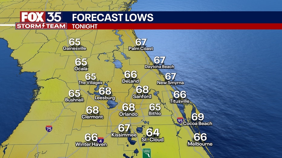
A lingering shower or two is possible though the overnight with some passing clouds. Lows will fall near 70.
WORK WEEK AHEAD:
What to Expect:
Sunday night and early Monday morning, a weak cold front starts to dip down into the peninsula and will bring some clouds and some cooler air into the region to start off the work week.
More scattered storms pop up on Monday afternoon with a 40% chance of showers and thunderstorms. The cold front that will slowly move through the region will allow for more widespread storms than what we saw on Sunday.
It wont be a washout of a day but storms are expected Monday afternoon and evening. Some storms could again pack a little bit of a punch and bring some HEAVY rain, gusty winds and small hail.
We DESPRATELY need rain, so as this rain is very much needed, just this one day of showers will not fix the current extreme drought conditions along the region. Burn bans are in place for nearly the entire region.
Middle of next week, we will see more of a pattern change. This means much higher chances of beneficial rain will be on the way, with multiple rounds possible.
Temps will be in the 80s through the start of the week.
The "cool down" does not last long. High pressure builds in once again with temps back on the rise into the middle and back half of the workweek. Highs are back in the lower 90s by Thursday and Friday.
FOX 35 Storm Tracker Radar and Live Weather Cameras
Track live when storms move across your area using the FOX 35 Storm Tracker Radar below. You can also watch as heavy rain moves across Central Florida on our Live Weather Cameras' page here.
More radar maps from FOX 35 Storm Tracker Radar
- Brevard County
- Flagler County
- Marion County
- Osceola County
- Orange County
- Polk County
- Seminole County
- Sumter County
- Volusia County
- U.S./National Radar
Stay connected with FOX 35
- Download the FOX 35 News app for latest news, weather, and traffic alerts
- Download the FOX 35 Storm Team Weather app for live, interactive radar
- Visit FOX35Orlando.com/weather for interactive radar, plus updated weather graphics, maps, and images
The Source: This story was written based on information shared by the FOX 35 Storm Team on April 27, 2025.