

Florida weather update: Windy Sunday as storm threat diminishes

Orlando Weather Forecast: December 17, 2023
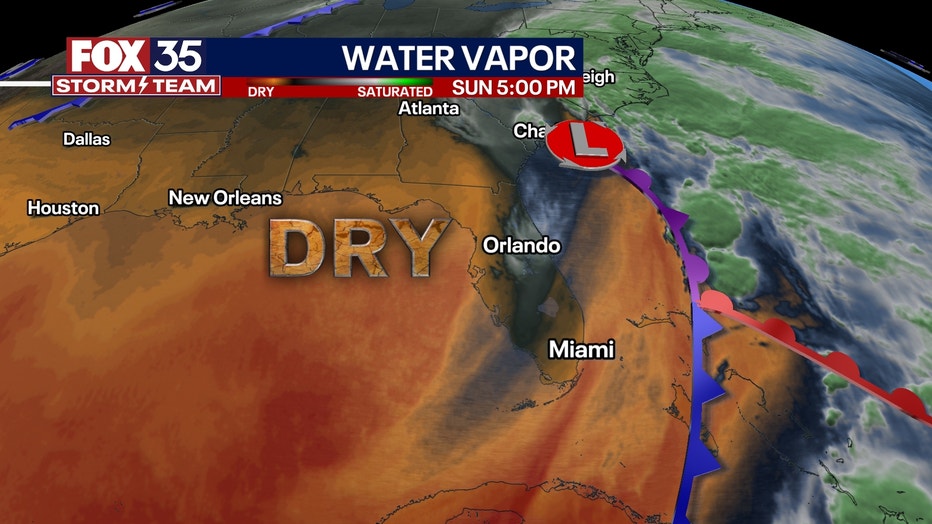
FOX 35 Chief Meteorologist Jayme King provides an update on the weather across Central Florida.
FLORIDA - Winds will continue to calm heading into tonight as our weekend system continues to move up the SE coastline. It will still remain breezy to begin the week with winds out of the west. Skies are expected to clear tonight as drier air moves in.
We'll see plenty of sunshine to begin the week. Cooler air is expected early this week with lows in the 50s tonight and highs in the mid 60s. Another front will usher in a reinforcing shot of drier, cooler air and bring lows into the 40s Tuesday and Wednesday morning.
ith a breezy wind, feels like temps will be chilly with wind chill values in the 30s north of I-4 to mid 40s elsewhere.
With drier air in place, we look to remain dry heading into the final weekend before Christmas. Long-term models do indicate some rainy weather could return in time for the holiday so keep an eye out for our latest forecasts.
Behind the departing storm, colder air will move in, putting Central Florida in the chill zone to kick off the new work and school week ahead. Sunshine will move back in during this time with pleasant weather expected!
Stay weather aware with FOX 35
- Download the FOX 35 News app for latest news, weather, and traffic alerts
- Download the FOX 35 Storm Team Weather app for live, interactive radar
- Visit FOX35Orlando.com/weather for interactive radar, plus updated weather graphics, maps, and images
- Radar Maps: Brevard County, Flagler County, Marion County, Osceola County, Orange County, Polk County, Seminole County, Sumter County, Volusia County
- FOX 35 Weather Cameras
- Current weather alerts
Live Weather Updates
5:17 a.m. | A Wind Advisory is in effect for all of east Central Florida. Officials are urging resident to stay out of the surf at area beaches due to the high rip current risk.
4 a.m. | FOX 35 Chief Meteorologist Jayme King provides an update on the weather system moving across Central Florida.

Orlando Weather Forecast - 4AM Update
FOX 35 Chief Meteorologist Jayme King provides an update on the weather system moving across Central Florida.
3 a.m. | FOX 35 Chief Meteorologist Jayme King provides an update on the weather system moving across Central Florida.

Orlando Weather Forecast - 3AM Update
FOX 35 Chief Meteorologist Jayme King provides an update on the weather system moving across Central Florida.

Florida weather update 1am: Here's the latest
FOX 35 meteorologist Ian Cassette provides an update on the weather forecast for Orlando and Central Florida.
10:41 p.m. | Flood Advisory for Lake, Orange, and Seminole counties until 1 a.m. More than 2" of rain has fallen and another 1"-2" of rain could fall as additional storms move through.
10:08 p.m. | No tornado watches or warnings issued for Florida. However, here is the area of concern that the NWS' Storm Prediction Center is monitoring.
FOX 35 meteorologist Ian Cassette hosted a Facebook Live where he went over the latest forecast, models, and talked about the potential weather threats we're anticipating late Saturday night and during the overnight hours. Watch below.
Resources:
- Download the FOX 35 News app for latest news, weather, and traffic alerts
- Download the FOX 35 Storm Team Weather app for live, interactive radar
- Visit FOX35Orlando.com/weather for interactive radar, plus updated weather graphics, maps, and images
8:21 p.m. | From FOX 35's Ian Cassette: "Our low pressure system is intensifying and with that, strong storms have developed near its center and attached cold front. This is what we will be watching closely overnight as it moves over Florida."
8:01 p.m. | So far, no tornado watches or warnings have been issued for Florida. However, the NWS Storm Prediction Center said it's possible watches or warnings could be issued for nearly all Central Florida and South Florida.
A tornado watch means weather conditions are right for the potential development of a tornado. A tornado warning means a tornado has formed and could be on the ground – either indicated by radar or a trained weather spotter. When a tornado warning is issued, seek shelter immediately.
7:41 p.m. | Flood Advisory issued for southeastern Brevard County, and northeastern Indian River County. More than 2" of rain has already fallen, per NWS, and another 1"-2" of rain could fall.
7:30 p.m. | Orlando and Kissimmee under flood advisories until 9:45 p.m. More than 2" of rain have fallen in this areas, NWS said.
What time is the rain going to start in Florida?
Rain looks to start somewhat light but slowly increases intensity as the day goes on. The heaviest rain arrives this afternoon, picking up overnight. Be mindful of localized flash flooding as the bulk of the rain arrives after the sun is set.
Along with the rain, gusty winds could become problematic with severe gusts above 45 mph expected. Combined with the heavy rain, the gusty winds will make driving conditions difficult and put quite a damper on any outdoor plans.
Stay weather aware with FOX 35
- Download the FOX 35 News app for latest news, weather, and traffic alerts
- Download the FOX 35 Storm Team Weather app for live, interactive radar
- Visit FOX35Orlando.com/weather for interactive radar, plus updated weather graphics, maps, and images
- Radar Maps: Brevard County, Flagler County, Marion County, Osceola County, Orange County, Polk County, Seminole County, Sumter County, Volusia County
- FOX 35 Weather Cameras

Is there a chance of a tornado?
Tornadoes can't be ruled out either as upper level wind shear keeps chances decent for a spin-up. There won't be much in terms of CAPE (convective available potential energy), or juice in the atmosphere, as the cloud cover looks to remain uniformly overcast as the nastiest weather arrives.
However, with winds out of the south and southeast, and an advancing system coming ashore from the west, southwest, this is the changing direction of winds with height, aka shear, to be mindful of which could help tornado development.
How bad are the severe storms going to be?
The Storm Prediction Center has issued a slight risk (2/5, yellow) for almost the entire state. This means scattered strong to possibly severe storms persisting this afternoon and into Sunday morning. The SPC is also highlighting damaging winds and tornadoes as the main threats (along with the heavy, flooding rain expected too).

Being weather aware today (and overnight) is of the utmost importance and be sure you have multiple ways to receive weather alerts if you need to act quickly in the event of a storm arriving where you live.
What will the weather be like on Monday, and next week?
Behind the departing system, get ready for a big-time drop in temperatures into the upcoming work week. Low pressure acts like a sink at the surface, so, cooler more dense air rushes toward the center of the low and spreads at the surface. This means cooler, drier air from the north will find a home in Florida, taking daytime highs back into the low 60s with overnight lows into the mid to low 40s. It might not be a bad idea to toss a jacket or your favorite "winter" layer into the car just in case you get chilly.