

Orlando weather: Hot, humid Sunday in Central Florida with potential for strong storms

Orlando Weather Forecast: April 16, 2023
FOX 35 Storm Team Meteorologist Ian Cassette has a look at Sunday evening's forecast.
ORLANDO, Fla - Today's high: 89 degrees | Tonight's low: 67 degrees
Main weather concerns:
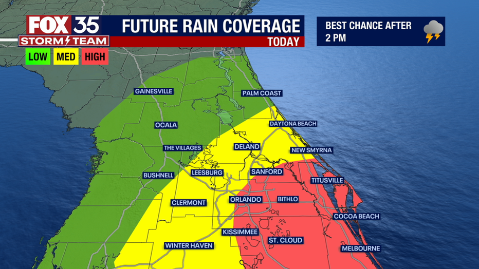
Hot and humid weather returns Sunday – and with the chance of storms. Scattered storms will become likely after 2 p.m. Sunday across Central Florida, though the highest chances for rain will be for those in the east. Strong storms are possible and some could become severe with potential for damaging winds, large hail, and frequent lightning. Timing is between 2 p.m. - 9 p.m.
BEACHES:
Conditions will be warm, but fair through early afternoon. We'll quickly turn stormy after that. Expect storms through sunset from Daytona Beach south through the Cape. A moderate rip current risk is expected with surf around 2 feet. Highs climb into the mid 80s ahead of the storms.

THEME PARKS:
It'll be a humid morning with temperatures climbing to near 90 today. Storms chances arrive in the early afternoon, and will continue through mid-afternoon. Storms likely won't clear out completely until 5 or 6 p.m. Download the FOX 35 News app and FOX 35 Storm Team app to receive notifications when storms and lightning are in your area.
OUTLOOK:
After a stormy and hot weekend, a cold front will move through Florida Sunday night. This will usher in a brief spell of cooler (and less humid) weather to begin the week. Highs return to the 70s to low 80s Monday and Tuesday with lows in the 50s Tuesday and Wednesday morning. Highs will gradually climb back to the upper 80s the rest of the week with likely dry weather.