

Orlando weather: Tropical Storm Chantal to bring heavy rain, thunderstorms, gusty winds

Orlando PM Weather Forecast: July 5, 2025
Meteorologist Laurel Blanchard breaks down the forecast for the rest of our holiday weekend and talks tropics.
ORLANDO, Fla. - Heavy rain and thunderstorms are expected this weekend across Central Florida as a result of Tropical Storm Chantal, according to the FOX 35 Storm Team and the National Hurricane Center (NHC).
Here's a look at what to expect from the weather today, tomorrow and heading into next week.
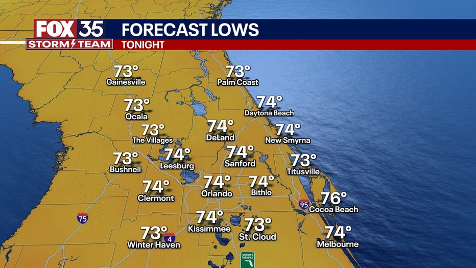
What will the weather look like tonight?
What To Expect:
Hit-and-miss showers and storms are expected for the rest of the evening with mostly cloudy skies.
The storms through the rest of the evening will not be as widespread as what we've seen in the past few days.
Partly to mostly cloudy skies will linger through the overnight, and temperatures will linger in the low-to-mid-70s.
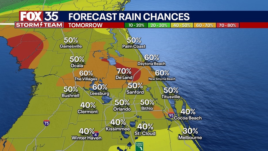
What will the weather look like tomorrow?
What's next:
Drier air will start to sink into Florida as a Northwest flow takes over due to Tropical Storm Chantal offshore. This will lower our chances of rain slightly on Sunday, making it a better day for outdoor activities.
SIGN-UP FOR FOX 35'S BREAKING NEWS, DAILY NEWS NEWSLETTERS
However, we will still see pop-up storms in the afternoon. So, if you are outside and hear thunder, get inside immediately. Chances are around 50% as our holiday weekend winds down.
Highs on Sunday will be around 90 degrees.
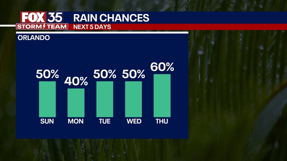
What will the weather look like next week?
Looking Ahead:
We kick off the workweek with drier conditions from the dry air being pulled in by Chantal.
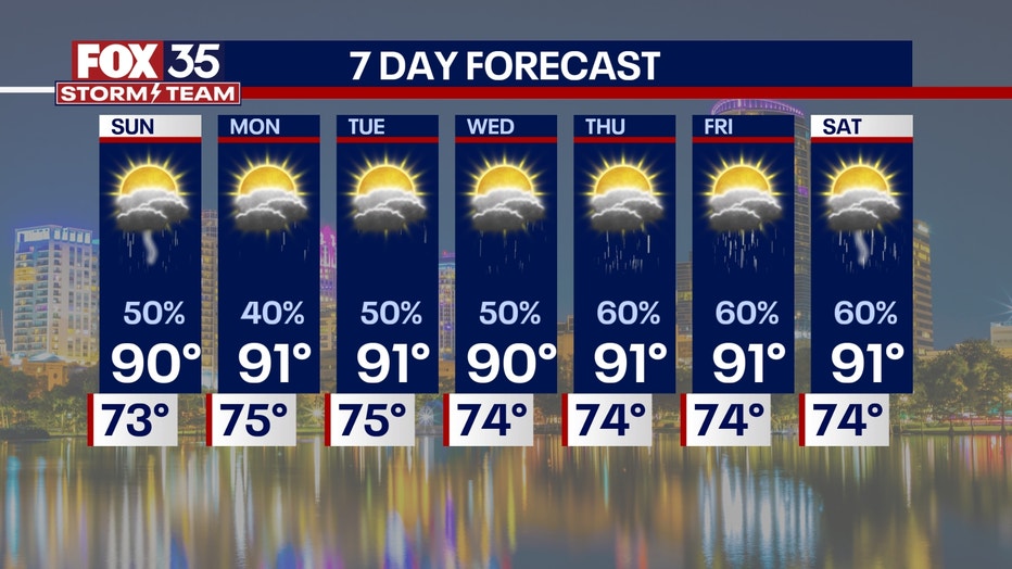
Highs start to rebound back into the low-90s as we dry out and get in on more sunshine early next week.
We will start to see the seabreeze storms start to take shape next week, and lows will linger in the low-and-mid-70s.
Tropical Storm Chantal
Big picture view:
The NHC says Tropical Depression 3, previously known as Invest 92L, has been upgraded to Tropical Storm Chantal.
The storm is expected to make landfall on the coast of South Carolina on Sunday morning, prompting Tropical Storm Warnings across parts of the state's beaches and promising a stormy end to the holiday weekend.
CLICK TO DOWNLOAD THE FOX LOCAL APP
The tropical storm is currently over warmer waters in the Gulf Stream, which has aided in the strengthening, evident with some stronger storms that have fired up.
Tropical storm-force winds are expected in the warning areas starting Saturday evening and lasting into Sunday morning. Gusts between 40-50 mph are possible.
The storm will likely strengthen more as we progress into Sunday morning. This could mean wind gusts getting at least up close to hurricane strength and bringing up to eight inches of rain to central North Carolina.
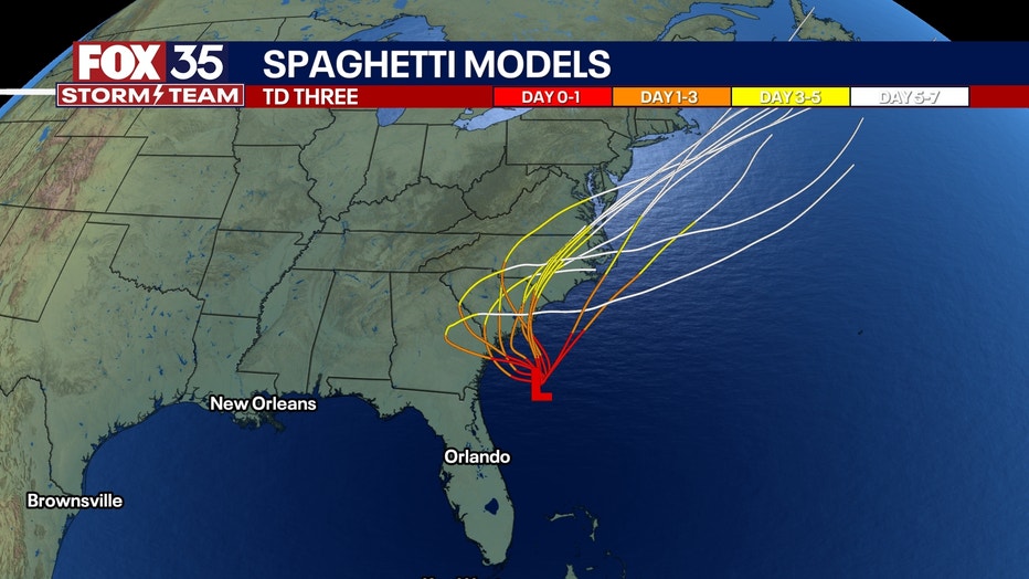
The tropical storm will then weaken as it moves inland but could still bring blustery conditions up toward the Mid-Atlantic heading into early next week.
The tropical storm could possibly reemerge in the Atlantic and reorganize next week, which is something we'll continue to monitor.
NHC officials say the system is expected to bring rough surf and rip currents to much of the Southeastern United States north of Northeastern Florida during the next couple of days.
The Source: This story was written based on information shared by the FOX 35 Storm Team, FOX Weather and the National Hurricane Center (NHC).