Orlando weather: Tuesday will be a touch cooler after record temps on Memorial Day

Orlando Weather Forecast: May 27, 2024
Showers and general thunderstorms will move southward across Central Florida on Tuesday. The activity will start mid-morning around Gainesville and continue until mid-evening around Brevard County.
ORLANDO, Fla. - Showers and general thunderstorms will move southward across Central Florida on Tuesday. The activity will start mid-morning around Gainesville and continue until mid-evening around Brevard County.
While severe weather is not anticipated, expect occasional downpours, lightning, and gusty winds.
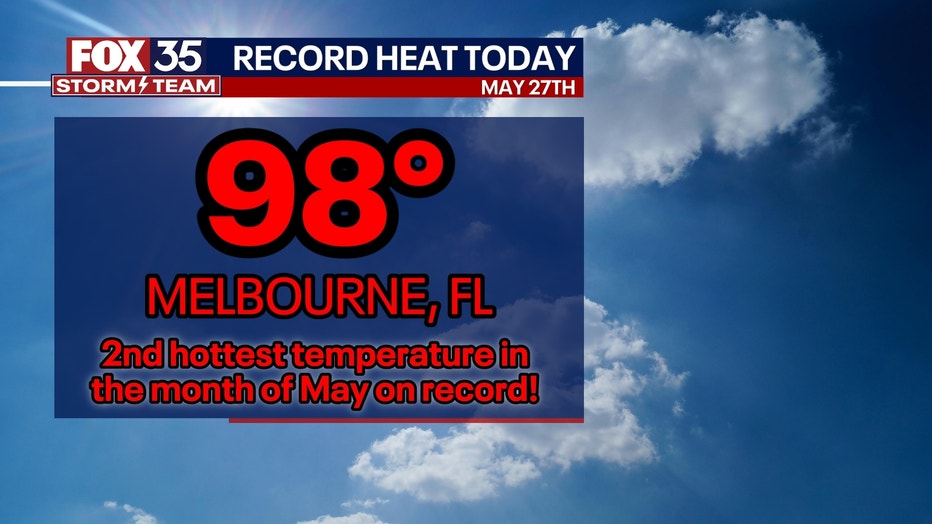
Memorial Day was a scorcher across much of the region, with some places setting new records. Melbourne, Florida, saw the second-hottest temperature ever recorded in the month of May on Monday at 98 degrees.
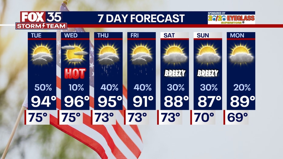
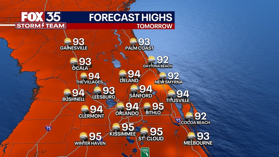
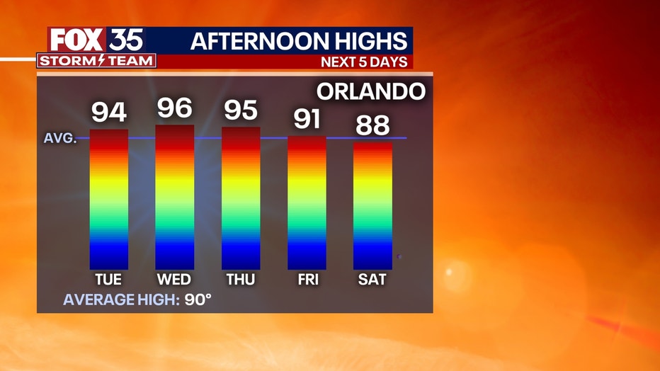
Tuesday will be a touch cooler, with temperatures in the low to mid-90s.
This weather pattern will reduce humidity on Wednesday, causing temperatures to rise into the upper 90s. The combination of low humidity and high temperatures will significantly increase the risk of brush and wildfires across central Florida.
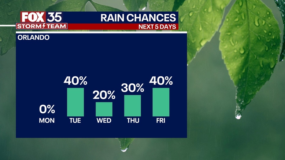
There's a 40% chance of sea breeze showers and storms on Thursday and Friday. Over the weekend, temperatures will cool, with afternoon highs reaching the upper 80s inland and the lower to mid-80s at the beaches.
No tropical development is expected over the next seven days. While there are indications that a weak system could potentially develop in the Caribbean in early June, it remains a distant possibility with a low chance of formation.
Central Florida Beach Weather Forecast
The beaches will be warm but not as hot as inland areas of Central Florida. Thanks to the seabreeze, afternoon high temperatures will climb into the upper 80s to near 90 degrees on the beaches. Just west of the Intracoastal, temperatures will quickly work into the 90s. Surf will be 1–2 feet with a moderate risk of rip currents, so keep a close eye on the little ones.
Florida Theme Park Weather Forecast
If you're from out of town or just not used to the Florida heat, pace yourself in the parks with lots of breaks in the AC and, of course, water. Drinking too much alcohol reduces heat tolerance and can make you sick, as it dehydrates the body, so be aware of that and play it safely.
Looking ahead:
A weak cold front will move our way tomorrow with a few afternoon storms, especially north of Interstate 4.
A few communities will get a quick downpour, while others remain dry. While it'll be hot for most of this short week, there are signs of some cooler air heading our way for the weekend as winds shift from the northeast off of the Atlantic Ocean. That means instead of highs near 100, they'll be closer to 90.