

Grace producing tropical storm force winds; portions of Central Florida in path
ORLANDO, Fla. - Tropical Storm Grace is producing tropical force winds as it moves over the Atlantic.
In a Saturday afternoon update, the National Hurricane Center says Grace is not very well organized. Hurricane hunters are investigating the storm.
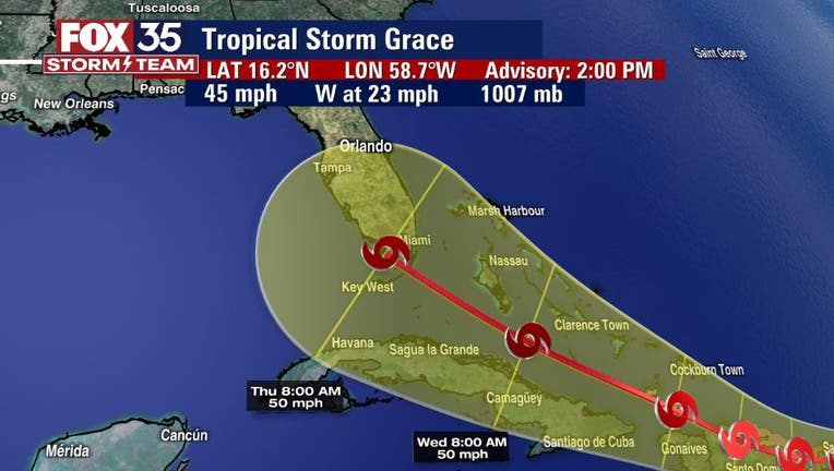
Grace formed overnight with parts of Central Florida now in its forecasted path. It's currently located east southeast of the Leeward Islands moving toward the west near 23 mph.
| WATCH LIVE TRACKING ON THE FOX 35 YOUTUBE CHANNEL |
"On the forecast track, the center of Grace is expected to move over the Leeward Islands tonight, over the Virgin Islands and Puerto Rico on Sunday, over the Dominican Republic on Monday, and then between the southeastern Bahamas and Cuba on Tuesday. Maximum sustained winds are near 45 mph with higher gusts," the NHC said.
Tropical-storm-force winds extend outward up to 35 miles from the center.
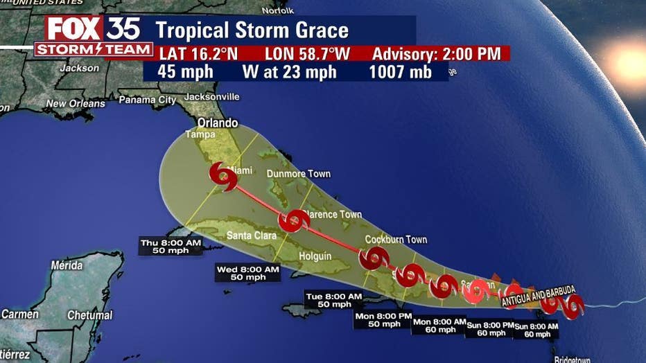
Some strengthening is forecast during the next day or so. Grace is likely to weaken while it moves near and across the Greater Antilles Sunday night through Monday night.
"The forecast track shows Grace impacting South Florida by the end of next week," said FOX 35 Storm Team Meteorologist Allison Gargaro. "There is a chance that central Florida will see more rain and storms, from this system, by the end of the work week and into the weekend."
Meanwhile, Fred has weakened into a tropical wave.
As of Saturday, Fred was located less than 200 miles south of Key West, Florida.
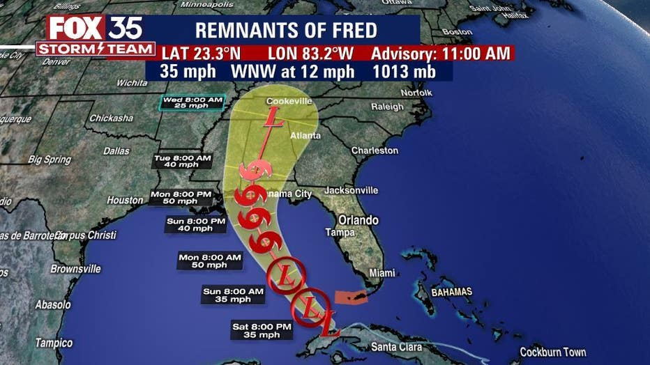
"The remnants are moving toward the west-northwest near 12 mph and this motion is expected to continue today. A turn toward the northwest is expected by tonight, followed by a northward motion by Sunday night," the NHC said.
On the forecast track, Fred or its remnants are expected to pass west of the lower Florida Keys this afternoon, move across the eastern Gulf of Mexico tonight through Monday, and move inland over the northern Gulf coast Monday night.
Maximum sustained winds are near 35 mph with higher gusts. Fred is expected to re-develop into a tropical depression on Sunday, with gradual strengthening to a tropical storm expected after the system re-develops.
A Tropical Storm Warning for the Florida Keys has been discontinued.
"Even though we won't see a direct impact from Fred, east central Florida will see bands of heavy rain and isolated storms through at least Monday," Gargaro said. "On Sunday, there is a marginal risk for some strong to severe storms, meaning there is a chance for an isolated tornado or two. We will be watching and tracking central Florida skies for you."
WEATHER ALERTS: Download the FOX 35 Storm Team Weather app for live radar, severe weather alerts, and daily forecast reports on your phone
| SUBSCRIBE TO FOX 35 ON YOUTUBE |
The FOX 35 Storm Team is tracking both systems every step of the way. Make sure you and your family have a plan in place as we get closer and closer to the peak of hurricane season.
Watch FOX 35 News for the latest updates throughout hurricane season.