

Tropical wave forms ahead of upcoming Atlantic hurricane season's official start

Tracking the Tropics: Disturbance over Hispaniola
We are monitoring the tropics before the official start of the hurricane season, which begins on June 1.
ORLANDO, Fla. - The National Hurricane Center has analyzed the first tropical wave of the upcoming hurricane season.
Satellite imagery captured late Wednesday morning showed a disturbance moving at 11 to 17 mph in the Central Atlantic southwest of the Cape Verde islands.

The wind shift associated with this wave supports scattered moderate convection; however, the disturbance is very unorganized, the NHC said.
Meanwhile, a small area of disturbed weather leaving the Caribbean and moving into the Atlantic is not expected to develop this weekend, with only a 10% chance of formation. It will bring heavy rains from Puerto Rico and Haiti to Bermuda over the holiday weekend.

Central Florida will enjoy mostly sunny skies through the weekend, with temperatures reaching the mid to upper 90s in inland areas. There may be some chances for pop-up showers and storms toward the end of next week, but those chances remain low.

Overall, Central Florida can expect a hot, dry, and mostly sunny pattern for the next week. Combining this trough with abundant tropical moisture will result in widespread rain across eastern Cuba, Jamaica, Hispaniola, and Puerto Rico through Friday.
In the meantime, all is quiet in the tropical activity zones that we usually watch for any development during the first month of the Atlantic hurricane season.

The 2024 Atlantic hurricane season begins on June 1, and pre-season forecasts indicate it could be another memorable year. The first named system in the Atlantic basin typically forms around mid-to-late June, with meteorologists tracking the first hurricane by August.

Noah Previews 2024 NOAA Hurricane Forecast
FOX 35's Storm Team Meteorologist Noah Bergren joins FOX 35's Garrett Wymer to preview the 2024 NOAA (National Oceanic and Atmospheric Administration) Hurricane forecast and what you could see this storm season.
In 2023, the U.S. mainland only experienced the direct impact of one hurricane, causing the quietest season for the Lower 48 in over a decade.
Despite a lack of U.S. impacts, 20 named storms formed, which included seven hurricanes.
The 2023 season occurred during an El Niño cycle, which is known to suppress tropical activity in the Caribbean, Gulf of Mexico, and Atlantic Ocean due to vertical wind shear and cooler water temperatures.
The opposite global weather pattern is expected to be in control in 2024, leading to more favorable atmospheric conditions across the Atlantic basin.
2024 Atlantic hurricane storm names
Twenty-one names make up the list for the Atlantic Ocean.
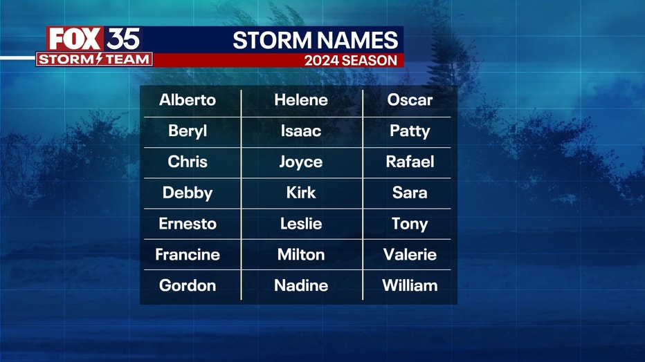
Here are the 2024 hurricane names with pronunciations:
- Alberto (al-BAIR-toe)
- Beryl (BEHR-ril)
- Chris (kris)
- Debby (DEH-bee)
- Ernesto (er-NES-toh)
- Francine (fran-SEEN)
- Gordon (GOR-duhn)
- Helene (heh-LEEN)
- Isaac (EYE-zik)
- Joyce (joys)
- Kirk (kurk)
- Leslie (LEHZ-lee)
- Milton (MIL-ton)
- Nadine (nay-DEEN)
- Oscar (AHS-kur)
- Patty (PAT-ee)
- Rafael (rah-fah-ELL)
- Sara (SAIR-uh)
- Tony (TOH-nee)
- Valerie (VAH-lur-ee)
- William (WILL-yum)
Hurricane prep: Start now
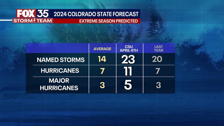
Colorado State University's prediction is significant because it's the most extreme season they've ever forecast since releasing their predictions publicly in the 1990s, FOX 35 Meteorologist Brooks Garner said.
This doesn't mean 23 tropical storms or 11 hurricanes will reach the United States or make landfall in Florida, as they can — and often do — curve away. But more storms do increase the chance of them possibly making landfall.
So, what should you do?
Think about preparing for hurricane season now.
- Do you have an emergency kit or an emergency plan ready? Have you double-checked supplies, batteries, or anything you'd need should the power go out for a couple of days or if you need to evacuate?
- Do you know your evacuation zone? Do you know the flood risk for where you live?
- Have you talked with your insurance company to make sure you're protected? Ask the professional about wind coverage and flood coverage.
There are several resources for emergency hurricane tips:
Some information taken from FOXWeather.com.