

7 facts to know about hurricanes
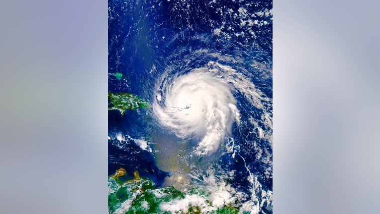
On Sept. 6th 2017, the Moderate Resolution Imaging Spectroradiometer or MODIS instrument aboard NASA's Aqua satellite captured a visible-light image of Hurricane Irma over the Leeward Islands and Puerto Rico. The image revealed a clear eye with power
ORLANDO, Fla. - Every summer and fall, masses of thunderstorms emerge off the coast of Africa, but when the conditions are just right, what started out as being a few thunderstorms can turn into some of the most destructive forces of Mother Nature - hurricanes.
Each year only around 14 of these low-pressure systems go on to gain sustained winds above 39 mph and earn a name.
Once winds reach the 74 mph threshold, the National Hurricane Center will declare the system a hurricane.
On average, the Atlantic basin only produces seven of these powerful storms each year.
Here are seven things to know about hurricanes.
HOW TO WATCH FOX WEATHER ON TV
A tropical storm becomes a hurricane once winds reach 74 mph
Since the 1970s, the National Hurricane Center has used a scale developed by Herbert Saffir, an engineer, and Robert Simpson, a meteorologist, to rate hurricanes.
The Saffir-Simpson Hurricane Scale has five categories that increase in intensity from 1 to 5.
Each category is defined by a sustained wind speed, which increases as a storm strengthens up the scale.
Meteorologists upgrade a tropical storm to a hurricane when sustained winds speeds reach at least 74 mph.
When winds are sustained anywhere from 74 mph to 95 mph, the cyclone is rated a Category 1 hurricane.
A Category 5 is the highest level a hurricane can achieve on the Saffir-Simpson Hurricane Scale.
HOW ARE HURRICANES RATED? THE SAFFIR-SIMPSON HURRICANE WIND SCALE EXPLAINED
Watches and warnings issued ahead of storm
Before a tropical cyclone bears down on an area, meteorologists at the National Oceanic and Atmospheric Administration have the responsibility of issuing Hurricane Watches and Hurricane Warnings ahead of potential impacts.
A Hurricane Watch means winds of 74 mph or greater are possible in the alerted area. A watch is usually issued 48 hours before the onset of tropical storm-force winds.
Emergency management officials warn that once winds reach around 40 mph, it becomes dangerous to continue to prepare for the storm.
A Hurricane Warning means winds of 74 mph or greater are expected in the alerted area. Hurricane warnings are typically hoisted 36 hours before the advance of life-threatening weather.
WATCH VS. WARNING: HERE ARE THE DIFFERENCES BETWEEN THESE WEATHER TERMS THAT COULD SAVE YOUR LIFE
Where the word hurricane comes from
Historians believe the word hurricane originated from the language of indigenous people of the Caribbean.
According to the Library of Congress, the Taíno people inhabited present-day Cuba, Jamaica, Haiti, the Dominican Republic, Puerto Rico, Bahamas and the Virgin Islands and are said to have used the word "hurucane."
Experts say "hurucane" represented the evil spirit of the wind to the Taíno.
Even though it is thought that the indigenous people faced extinction by diseases brought by Spanish explorers, their languages, beliefs and cultures continued to live on.
Tropical systems are the only weather phenomena given names
Tropcial cyclones are the only weather systems that are given names when they transverse the world’s oceans.
The National Hurricane Center says naming hurricanes helps the communication process for identifying and relaying information about these dangerous storms.
Experts believe islanders in the Caribbean started naming cyclones during the 1800s, but it wasn’t until 1950 that the U.S. Weather Bureau began the naming process.
The current naming scheme wasn’t developed until 1979, when both male and female names were added to lists that are recycled every six years.
Inland flooding considered a hidden danger of tropical cyclones
NOAA says flooding accounts for more than 50 percent of hurricane-related deaths each year, and many happen inland.
From 1963-2012, the agency reports 25 percent U.S. deaths happened in inland counties.
NOAA says it has increased education and its collaboration to address issues related to inland complacency during storms.
But the agency notes, rainfall predictions are challenging because a slight shift in a hurricane’s path can mean large differences in which areas will flood and which will escape the potentially deadly effect.
It is not unheard of for areas to see feet of rain from a hurricane.
Hurricane Harvey dumped more than 60 inches of rain in southeast Texas in 2017.
First reconnaissance flight into a hurricane was in 1943
The National Weather Service says the first record it has of a flight purposefully flying into a hurricane dates back to 1943 off the coast of Texas.
British and American pilots were said to be training for World War II in the Lone Star State, when the storm approached, and a crew purposefully flew into the storm.
The squadron we know today as the "Hurricane Hunters" didn’t start surveying cyclones until 1946.
Today, there are dozens of planes from both the Air Force and NOAA devoted to monitoring and researching these massive storms.
HURRICANE HUNTING EVOLVES WITH NEW TECHNOLOGY
Hurricane season runs from June 1 through November 30
The Atlantic basin hurricane season officially runs from the start of meteorological summer through November.
NOAA’s Hurricane Research Division reports that 97% of all tropical cyclones happen during this time period.
Meteorologists say it is during these months that breaks in upper-level winds patterns happen, which allows tropical cyclones to develop.
Hurricanes favor warm, deep water with at least a temperature of 78 degrees in order to grow.
These environmental conditions can become widespread during the latter half of August through September, making this time period the peak of the season.
HERE ARE THE NAMES YOU’LL SEE DURING THE 2022 ATLANTIC HURRICANE SEASON