

Tropical Storm Sally expected to become a hurricane on Monday; 5 other systems being tracked

ORLANDO, Fla. - Central Florida will have a rainy Sunday as strengthening Tropical Storm Sally pushes heavy rains and gusty winds into the region.
FOX 35 is tracking six systems in the tropics: Hurricane Paulette, Tropical Storm Sally, Tropical Depression Rene, Tropical Depression 20 and two more disturbances on the outskirts that have the potential for formation.
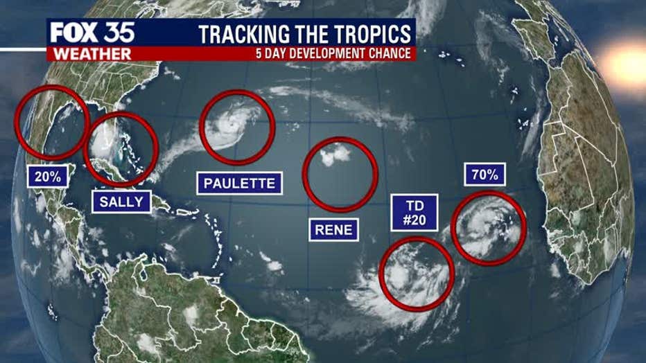
TROPICAL STORM SALLY
As things currently stand, Tropical Storm Sally will have the greatest effect on Central Florida. It is currently located about 140 miles south-southwest of Apalachicola, Florida. It is moving west-northwest at 12 mph, the National Hurricane Center (NHC) says.
Sally's rainbands are already impacting east-Central Florida. They will continue to push north, increasing showers throughout mid-morning and the early afternoon. In addition, the region will see gusty winds and heavy rain.
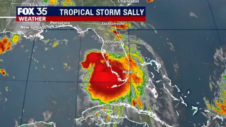
The tropical storm will push off into the Gulf of Mexico as it moves west-northwest, moving into very warm water. This will strengthen it rapidly. Sally currently has maximum sustained winds of 60 mph but those are expected to increase to 70 mph by Monday morning. Then, by Monday night, Sally could become a Category 1 hurricane with 80 mph winds. It has the potential to become a Category 2 but it will die down quickly once it moves inland.
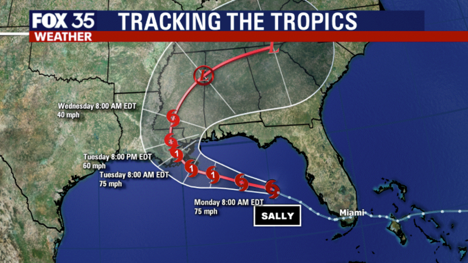
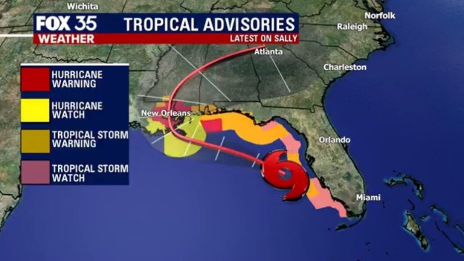
The NHC says that Sally is expected to impact the north-central Gulf Coast on late Monday and Tuesday. As a result, the following watches and warnings are in effect:
Hurricane Warning:
- Morgan City Louisiana to Ocean Springs Mississippi
- Lake Pontchartrain and Lake Maurepas including metropolitan New Orleans
Hurricane Watch:
- East of Ocean Springs to the Alabama/Florida Border
Tropical Storm Warning:
- East of Ocean Springs to Indian Pass
- Intracoastal City Louisiana to west of Morgan City
Tropical Storm Watch:
- Indian Pass to Ochlockonee River, Florida
Storm Surge Warning:
- Port Fourchon, Louisiana to the Mississippi/Alabama Border
- Lake Pontchartrain, Lake Maurepas, and Lake Borgne
Storm Surge Watch:
- Mississippi/Alabama Border to the Alabama/Florida Border
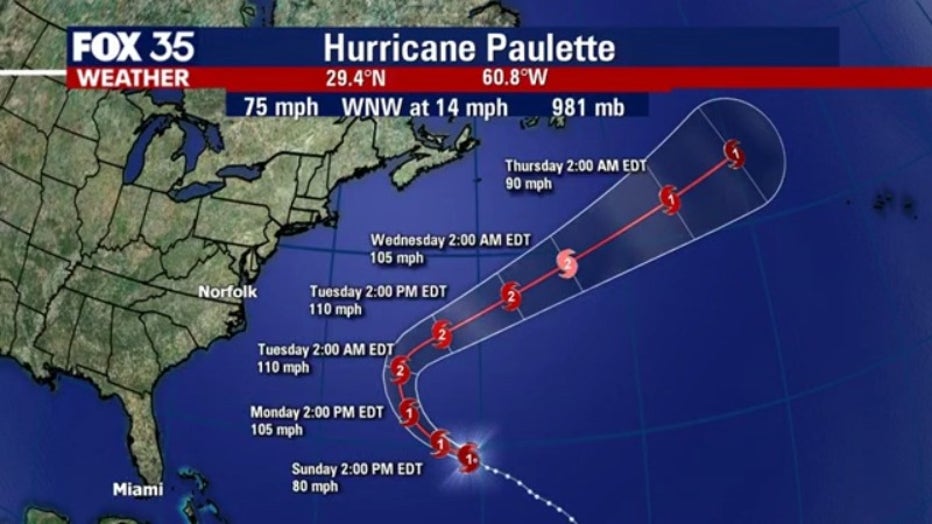
HURRICANE PAULETTE
The NHC says that Hurricane Paulette is located about 195 miles southeast of Bermuda, moving northwest at 14 mph. They expect it to move near or over Bermuda on Monday.
It reportedly has maximum sustained winds of 85 mph and additional strengthening is forecasted. It is expected to be a dangerous hurricane when it approaches Bermuda. A Hurricane Warning is currently in effect for Bermuda.
FOX 35 meteorologist Allison Gargaro says that it will not impact Florida but will bring an increase in swell heights to the state's coast.
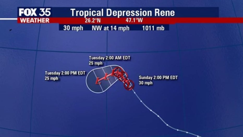
TROPICAL DEPRESSION RENE
Meanwhile, Tropical Depression Rene is said to be swirling in the Atlantic, away from land. It is moving northwest near 9 mph with maximum sustained winds of 30 mph.
Rene is expected to weaken, as Meteorologist Gargaro said that it is falling apart quickly and will be a remnant low within the next day or so.
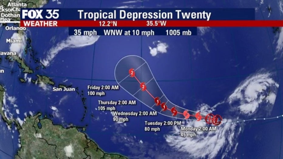
TROPICAL DEPRESSION 20
The NHC says that Tropical Depression 20 is currently located about 870 miles west-southwest of the Cabo Verde Islands. It is moving west-northwest at 10 mph.
The depression currently has maximum sustained winds of 35 mph and gradual strengthening is expected over the next few days. It is expected to become a tropical storm on Sunday. Then by Wednesday, it is expected to become a Category 1 hurricane. It is then forecasted to become a Category 2 by Friday.
As of now, there are no coastal watches or warnings in effect but FOX 35 will continue to track this depression for its possible impact on land.
OTHER SYSTEMS
There are two other disturbances moving in the tropics.
One of them is a surface trough moving through the Gulf of Mexico between 5 to 10 mph. The NHC says it is producing limited shower activity. Any development of the system is expected to be slow. Its chances of developing are between 10 and 20 percent.
The other disturbance is located a little over a hundred miles from the Cabo Verde Islands, the NHC says. It is moving north-northwest between 5 to 10 mph. Its shower and thunderstorm activity is reportedly showing some signs of organization. Environmental conditions are expected to be conducive for additional development. Its chances for development are 70 percent. It is likely to become a tropical depression by Tuesday.
TRACK THE TROPICS: Visit the FOX 35 Orlando Hurricane Center for the latest in the tropics, including daily updates, live radar, and severe weather alerts
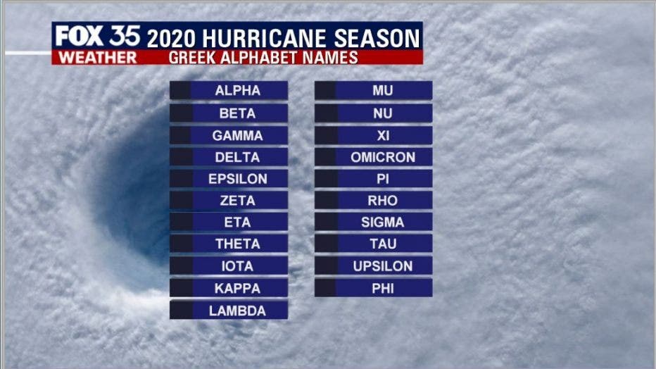
If any other storms develop, the remaining names are Teddy, Vicky, and Wilfred.
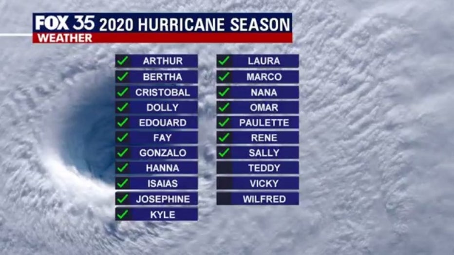
If we move through these last three names, we will begin to use a list of names based on the Greek alphabet for any other storms that develop.
Forecasters have predicted that this season will have more activity than normal. For example, NOAA predicted an above-average season, with 13 to 19 named storms. Six to 10 of those would become hurricanes and three to six of those are forecasted to become major hurricanes (Category 3 or higher).
In comparison, the 2019 Atlantic Hurricane season had 18 named storms, matching 1969 for the fourth most-lively season in the past 150 years.
Hurricane season runs through November 30.
Tune in to FOX 35 Orlando for the latest updates on the tropics.