

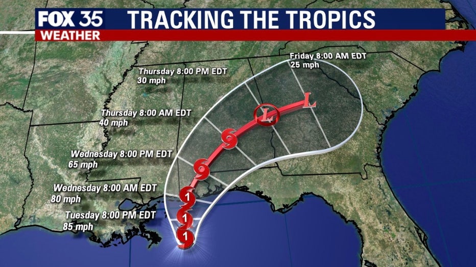
Hurricane Sally strengthens as it approaches Gulf Coast

Tracking the Tropics: September 15, 2020
Hurricane Sally is expected to strengthen during landfall, then the system will track to the north and east.
ORLANDO, Fla. - Forecasters say Hurricane Sally has become a little stronger as it crawls closer to the northern U.S. Gulf Coast.
The National Hurricane Center in Miami said on Tuesday evening that Sally's top sustained winds had risen from 80 mph (128 kph) to near 85 mph (140 kph) as it lumbered offshore.
Forecasters said Sally could strengthen some more before its center reaches the northern Gulf Coast on Wednesday.
The storm was last centered about 62 miles south of Mobile, Alabama, and virtually the same distance southwest of Pensacola, Florida. It's moving to the north toward the coast at 2 mph (4 kph).
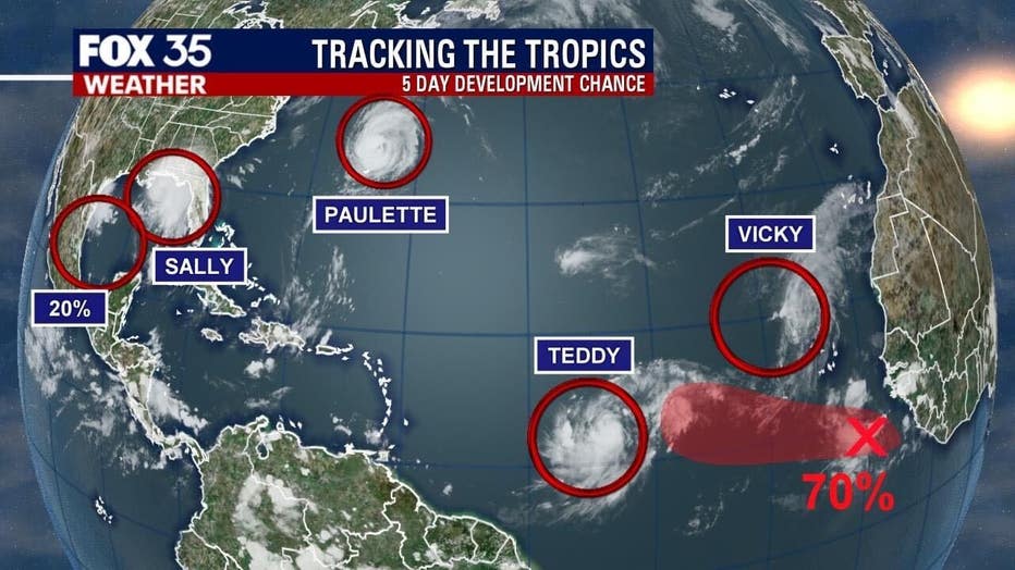
FOX 35 is monitoring several systems in the tropics: Hurricane Sally, Hurricane Paulette, Tropical Storm Teddy, Tropical Storm Vicky, a wave off the coast of the Cabo Verde Islands, a disturbance in the Gulf of Mexico, and a non-tropical area of low pressure several hundred miles northeast of the Azores.
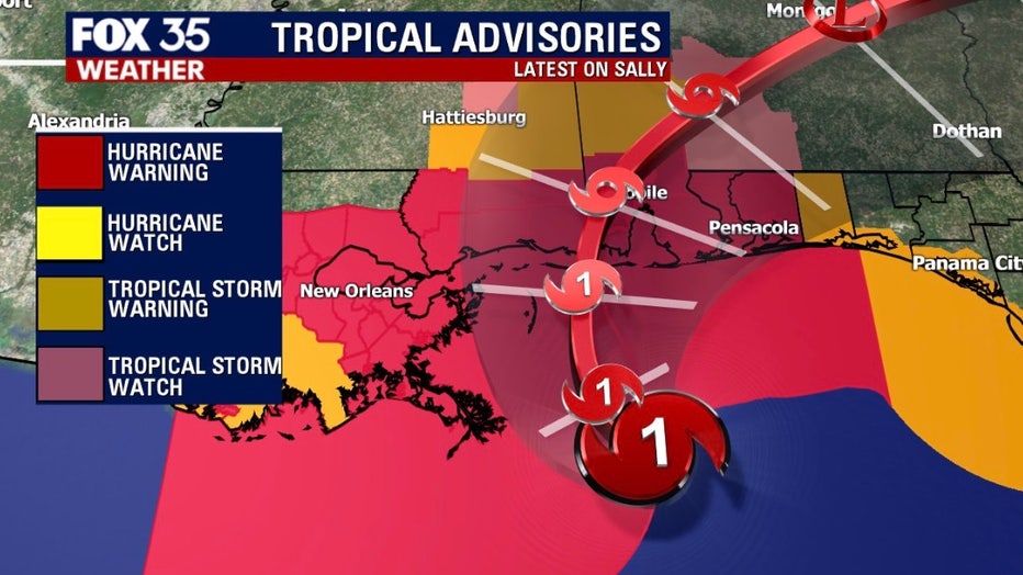
HURRICANE SALLY
Hurricane Sally is currently located about 60 miles east of the Mississippi River. It is inching closer to the northern Gulf Coast and is expected to make landfall late Tuesday or Wednesday.
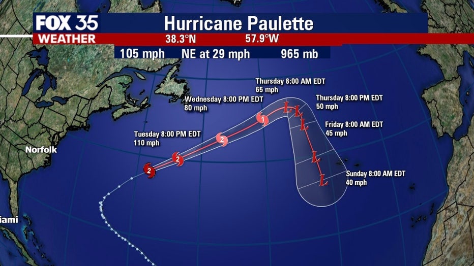
HURRICANE PAULETTE
Hurricane Paulette is moving northeast at 29 mph with maximum sustained winds of 105 mph. The NHC said that some strengthening is possible through Tuesday night, but rapid weakening is forecasted to begin on Wednesday.
TROPICAL STORM TEDDY
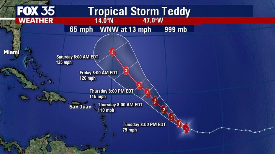
Tropical Storm Teddy is about 960 miles east of the Lesser Antilles and is moving towards the west-northwest at 13 mph. The storm is packing maximum sustained winds of 65 mph and is forecasted to become a 'large and powerful' hurricane on Tuesday or Wednesday. The NHC also expects that it will eventually become a major hurricane -- Category 3 or higher.
TROPICAL STORM VICKY
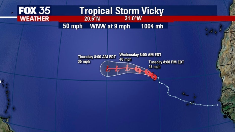
Tropical Storm Vicky is about 560 miles northwest of the Cabo Verde Islands and is moving west-northwest at 9 mph. The NHC said that it has maximum sustained winds of 50 mph. Weakening is expected over the next two days due to strong upper-level winds. It should degenerate into a remnant low by Wednesday night.
OTHER DEVELOPING SYSTEMS
On the coast of Africa is a tropical wave that is producing showers and thunderstorms. Environmental conditions are conducive for development and a tropical depression is likely to form over the next few days, the NHC said. It moving westward at about 10 to 15 mph and has a 70 percent of development.
There is also a weak area of low pressure over the west-central Gulf of Mexico that continues to produce limited shower activity. It is not expected to develop much further, with chances over the next five days at 20 percent.
A non-tropical area of low pressure is located over the far northeastern Atlantic Ocean several hundred miles northeast of the Azores. This system is forecasted to move south-southeastward during the next few days. Forecasters give it a 20 percent chance of developing over the next five days.
TRACK THE TROPICS: Visit the FOX 35 Orlando Hurricane Center for the latest in the tropics, including daily updates, live radar, and severe weather alerts
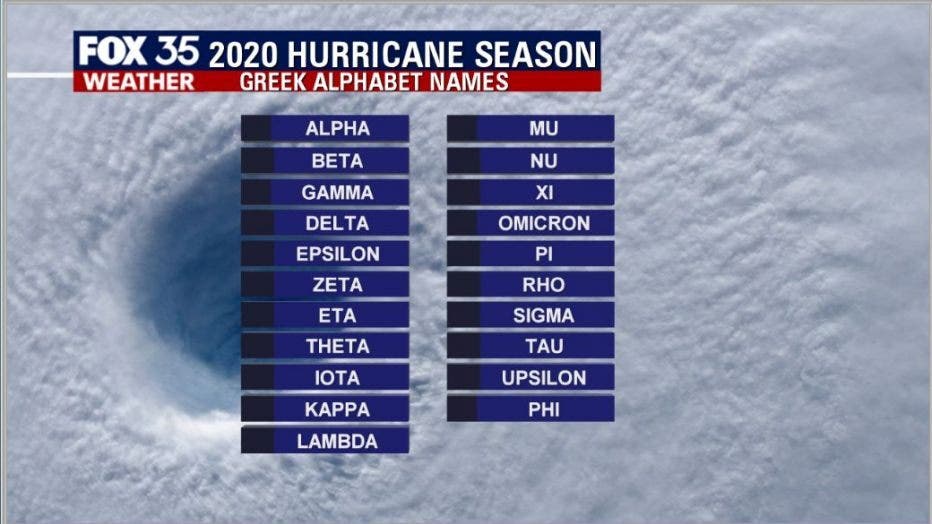
If any other storms develop, the last remaining name is Wilfred. Then, we will begin to use a list of names based on the Greek alphabet for any other storms that develop. The last time this backup list of names was used was in 2005. There were 28 named storms that year.
Forecasters have predicted that this season will have more activity than normal. For example, NOAA predicted an above-average season, with 13 to 19 named storms. Six to 10 of those would become hurricanes and three to six of those are forecasted to become major hurricanes (Category 3 or higher).
In comparison, the 2019 Atlantic Hurricane season had 18 named storms, matching 1969 for the fourth most-lively season in the past 150 years.
Hurricane season runs through November 30.
Tune in to FOX 35 Orlando for the latest updates on the tropics.