

Orlando weather: Temperatures plunge as cold front pushes through Central Florida

Orlando Weather Forecast: March 18, 2024
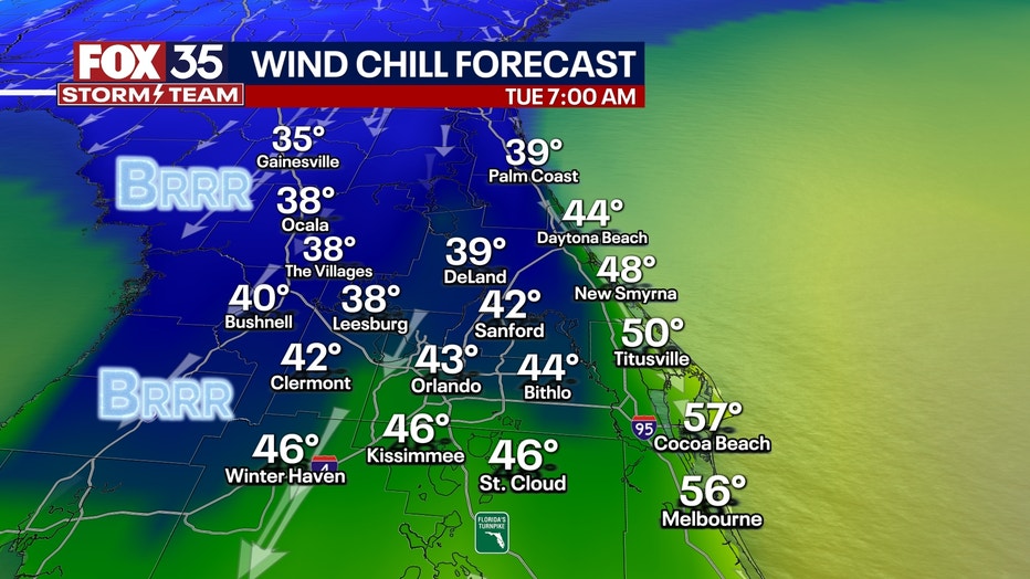
Temperatures will plunge after a beautiful Monday with highs breaking into the 80s. Highs on Tuesday will reach the 60s over many areas, with lows in the 40s.
ORLANDO, Fla. - There will be abundant sunshine on Tuesday, with gusty NW winds of 10-25 mph all day. It will be in the 40s and 50s on Tuesday morning, though with the wind, it will feel much colder than that. Highs barely get much past 61 in some spots on Tuesday afternoon.

BEACH FORECAST: For locals and spring breakers, these next few days will be bright but quite chilly. Bring a sweatshirt or long sleeves and a hat. This week, high tide will be in the mid-afternoon, with 3-6 foot surf on Tuesday and 2–4 feet on Wednesday, with a moderate to high rip current risk.
THEME PARK FORECAST: It will be bright but chilly the next few days. Friday will be a wet day in the parks.

Wednesday morning winds will be lighter, which will allow air temps to fall more.

Friday is a FOX 35 Weather Impact Day
Friday is a FOX 35 "Weather Impact Day" because of the chance for heavy rain and/or severe storms. The specific timing, amount, and severity of rain and storms is still TBD and based on the track of low pressure coming out of the Gulf, and across the state. Over 2" of rain may fall somewhere in central Florida.


Right now, we are optimistic much of this activity will clear by Saturday morning, yielding gusty winds with dry weather on Saturday and Sunday. Check back for updates as we get closer, especially regarding the risk of storms.
