

Hurricane forecasters track 2 disturbances in the Atlantic

Tracking the Tropics: June 24, 2021
FOX 35 Storm Team Meteorologist Brooks Garner gives the latest in the tropics.
ORLANDO, Fla. - The National Hurricane Center (NHC) is tracking two disturbances in the Atlantic.
They said the first disturbance, located about 100 miles east-southeast of Barbados, is made up of disorganized showers and thunderstorm activity. It is apparently decreasing into a small area of low pressure and upper-level winds are likely to prevent further development.
TRACK THE TROPICS: Visit the FOX 35 Storm Team Hurricane Center for the latest tropical weather outlook and more
Nonetheless, it is said to be moving west-northwest at 10 mph. It has just a 10 percent chance of formation over the next two to five days.
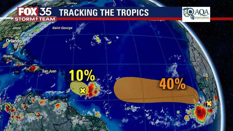
Meanwhile, the NHC said that a small tropical wave has emerged just off the coast of Africa.
WEATHER ALERTS: Download the FOX 35 Storm Team Weather app for live radar, severe weather alerts, and daily forecast reports on your phone
"Although ocean temperatures are still relatively cool over the tropical Atlantic Ocean and are only marginally conducive for development, a small tropical depression could form by early next week," NHC forecasters said.
The tropical wave is moving westward to west-northwestward at about 15 mph. It has a 20 percent chance of formation over the next two days and a 40 percent chance of formation over the next five days. If it becomes a named storm, it will be called ‘Danny.’
Watch FOX 35 Orlando for the latest tropical updates.