

FOX 35 Weather Impact Day: Triple digit heat index to conclude the weekend

Orlando PM Weather Forecast: July 20, 2025
Meteorologist Laurel Blanchard has the details on the heat wave and when we see the widespread rain back in the forecast.
What will the weather look like tonight?
What To Expect:
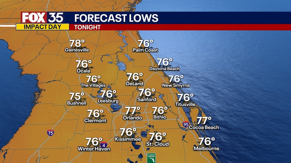
ORLANDO, Fla. - A couple of isolated storms will pop up this evening but fizzle in the early overnight. Temperatures will stay hot through the rest of the evening with mild temperatures through the overnight bottoming out in the mid and upper 70s. Mainly clear skies are on tap through the overnight hours.
What will the weather look like on Monday?
What To Expect:
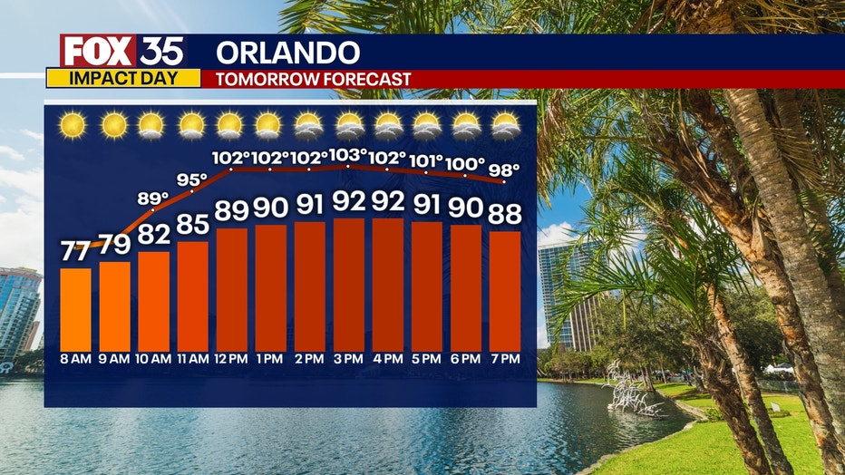
We are back in an unsettled pattern next week. Starting Monday the storms are back as the high pressure that gave us the heat and sun this weekend shifts to the west.
This will cool our temperatures down a little bit.
What will the weather look like the rest of the week?
Looking ahead:
Storms will become much more widespread on Tuesday, Wednesday and Thursday.
Although Invest-93L has fizzled, the moisture from the system is still in the atmosphere and will ride around the high pressure in the Gulf and really amp up our rain chances early and midweek.
Storms start off scattered on Monday and much more widespread rain really kicks back in from the moisture making its way back over the peninsula Tuesday through Friday.
With all the moisture in the air, flooding could be a concern, which is something we'll be watching closely.
Another thing we'll be monitoring is if this low could reorganize into a depression as it works closer to the Gulf.
Main threats: HEAVY tropical downpours, gusty winds, vivid lightning and small hail with stronger storms.
Tracking the Tropics: 2PM Sunday
Looking ahead:
Still the same% as the update from this morning. Still defined as a disturbance, which is a cluster of thunderstorms that has very little organization.
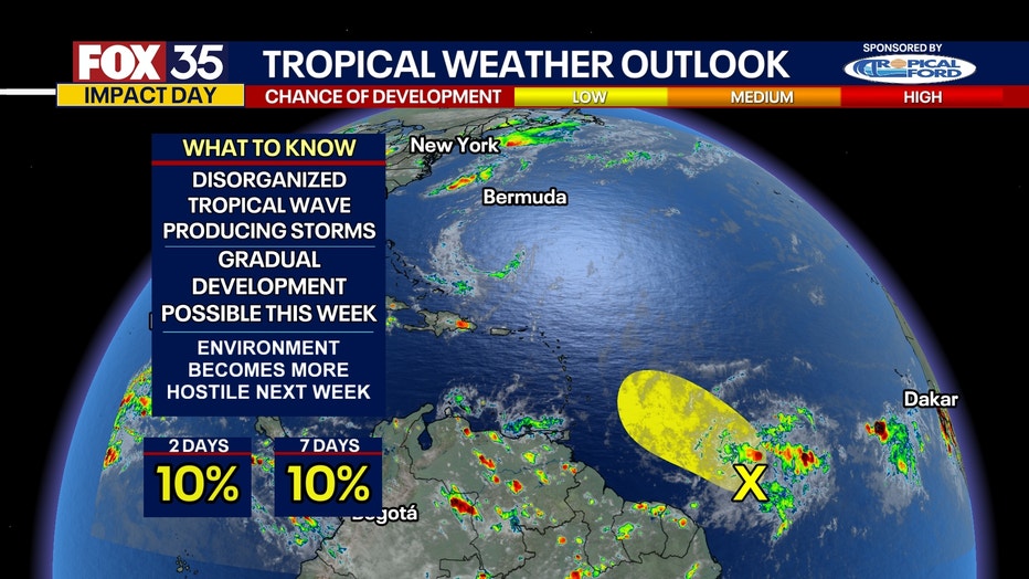
This disturbance has a 10% chance of development over the next 7 days. It looks to encounter a more hostile environment later next week that should limit any sort of major development.
FOX 35 Storm Tracker Radar and Live Weather Cameras
Track live when storms move across your area using the FOX 35 Storm Tracker Radar below. You can also watch as heavy rain moves across Central Florida on our Live Weather Cameras' page here.

More radar maps from FOX 35 Storm Tracker Radar
- Brevard County
- Flagler County
- Lake County
- Marion County
- Osceola County
- Orange County
- Polk County
- Seminole County
- Sumter County
- Volusia County
- U.S./National Radar
The Source: This story was written based off information shared by the FOX 35 Storm Team on July 20, 2025.