

Warning, Watch, Advisory: What's the difference?

NOAA releases 2025 Atlantic hurricane season outlook
The hurricane season outlook from NOAA was just released, and they are calling for an above-average number of tropical storms this year and a near normal or above-normal number of hurricanes.
HOUSTON - Throughout the 2025 hurricane season, you will hear meteorologists use terms like warning, watch and advisory, but what do they mean?
The local National Weather Service office knows the area and will issue Warnings, Watches or Advisories based on local criteria.
Hurricane and tropical storm watches and warnings for winds on land as well as storm surge watches and warnings can be issued for storms that the NWS believes will become tropical cyclones but have not yet attained all the characteristics of a tropical cyclone. In these cases, the forecast conditions on land warrant alerting the public. These storms are referred to as "potential tropical cyclones" by the NWS.
Hurricane, tropical storm, and storm surge watches and warnings can also be issued for storms that have lost some or all of their tropical cyclone characteristics, but continue to produce dangerous conditions. These storms are called "post-tropical cyclones" by the NWS.
Either way, when you see a Watch, Warning or Advisory, here is what you need to know.
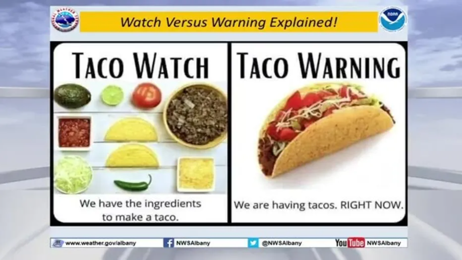
The easiest way to explain a Watch versus a Warning is with tacos. If you have the ingredients to make a taco, you have a watch. If the taco is made, you have a warning. An advisory would be if you knew Taco Tuesday was coming, so you should be preparing for it.
Warnings
- Storm Surge Warning: There is a danger of life-threatening inundation from rising water moving inland from the shoreline somewhere within the specified area, generally within 36 hours. If you are under a storm surge warning, check for evacuation orders from your local officials.
- Hurricane Warning: Hurricane conditions (sustained winds of 74 mph or greater) are expected somewhere within the specified area. NHC issues a hurricane warning 36 hours in advance of tropical storm-force winds to give you time to complete your preparations. All preparations should be complete. Evacuate immediately if so ordered.
- Tropical Storm Warning: Tropical storm conditions (sustained winds of 39 to 73 mph) are expected within your area within 36 hours.
- Extreme Wind Warning: Extreme sustained winds of a major hurricane (115 mph or greater), usually associated with the eyewall, are expected to begin within an hour. Take immediate shelter in the interior portion of a well-built structure.
Watches
- Storm Surge Watch: There is a possibility of life-threatening inundation from rising water moving inland from the shoreline somewhere within the specified area, generally within 48 hours.
- Hurricane Watch: Hurricane conditions (sustained winds of 74 mph or greater) are possible within your area. Because it may not be safe to prepare for a hurricane once winds reach tropical storm force, the NHC issues hurricane watches 48 hours before it anticipates tropical storm-force winds.
- Tropical Storm Watch: Tropical storm conditions (sustained winds of 39 to 73 mph) are possible within the specified area within 48 hours.
Advisories
- Tropical Cyclone Public Advisory: The Tropical Cyclone Public Advisory contains a list of all current coastal watches and warnings associated with an ongoing or potential tropical cyclone, a post-tropical cyclone, or a subtropical cyclone. It also provides the cyclone position, maximum sustained winds, current motion, and a description of the hazards associated with the storm.
- Tropical Cyclone Track Forecast Cone: This graphic shows areas under tropical storm and hurricane watches and warnings, the current position of the center of the storm, and its predicted track. Forecast uncertainty is conveyed on the graphic by a "cone" (white and stippled areas) drawn such that the center of the storm will remain within the cone about 60 to 70 percent of the time. Remember, the effects of a tropical cyclone can span hundreds of miles. Areas well outside the cone often experience hazards such as tornadoes or inland flooding from heavy rain.
2025 Hurricane Season
In Texas, the hurricane season officially runs from June 1 to November 30. The highest risk of storms, including hurricanes and tropical storms, is generally from August to October, particularly as the Gulf's sea surface temperatures are warmest during these months.
NOAA is predicting 13 to 19 named storms, 6 to 10 hurricanes and 3 to 5 major hurricanes. Now is the time to prepare.
The Source: Information in this article is from the National Oceanic and Atmospheric Administration.