

Tropical wave Invest-98L could have impact on Florida as named storm Hermine

Will a hurricane impact Florida next week? The latest on Invest-98L, Hurricane Fiona
FOX 35 Storm Team Chief Meteorologist Jayme King has the forecast.
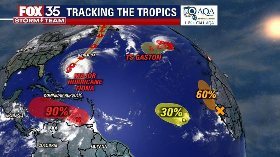
ORLANDO, Fla. - The FOX 35 Storm Team continues to track a lot of activity in the tropics – Hurricane Fiona and Tropical Storm Gaston – as well as tropical wave Invest-98L which could have an impact on Florida as our next named storm of the season, Hermine.
TROPICAL WAVE INVEST-98L
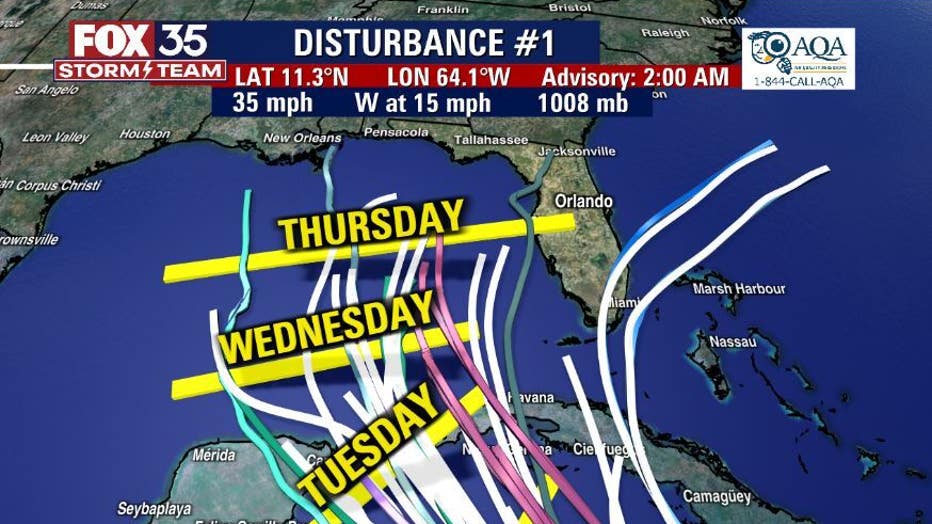
On Thursday, the tropical wave was located over the far southeastern Caribbean Sea near Trinidad and has a 90-percent chance of developing. The system is forecast to become a little more favorable in a couple of days, and a tropical depression is likely to form at that time.
"Disturbance 1 will be named Hermine once intensity reaches tropical storm status," said FOX 35 Storm Team Chief Meteorologist Jayme King said. "Long range models bring this system closer to the Northwest Caribbean or Southern Gulf of Mexico by early next week. Right now, there's much disagreement amongst many of the tropical models.
RELATED: Hurricane Hermine hit Florida in 2016: Will it happen for a second time?
King says the Euro model shows the system making an impact on the Florida peninsula on Thursday, Sept. 29 while the GFS model has a more westerly track and has it going toward the central Gulf of Mexico.
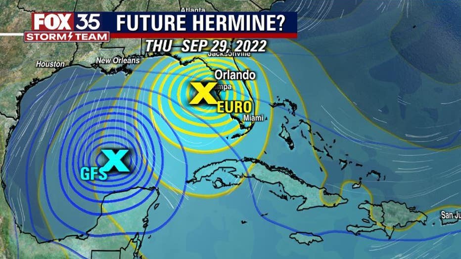
Remember, that things can change and the forecast track is uncertain at this time. Florida should be vigilant over the next several days.
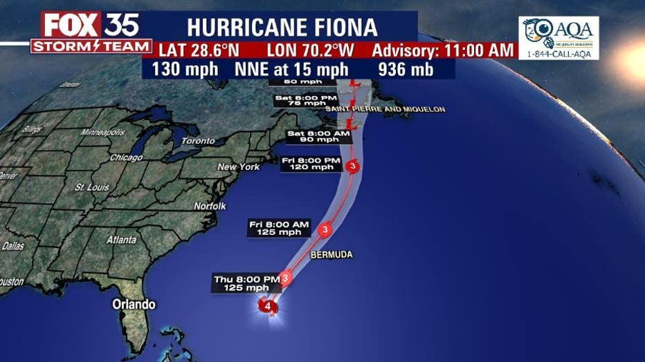
HURRICANE FIONA
On Thursday, Fiona was located south-southwest of Halifax Nova Scotia with maximum sustained winds of 130 mph, which makes it a powerful Category 4 hurricane. In the 2 p.m. update, the National Hurricane Center said the outer bands of Fiona are reaching Bermuda and there is a risk of significant impacts from wind, storm surge, and heavy rainfall increasing for Atlantic Canada.
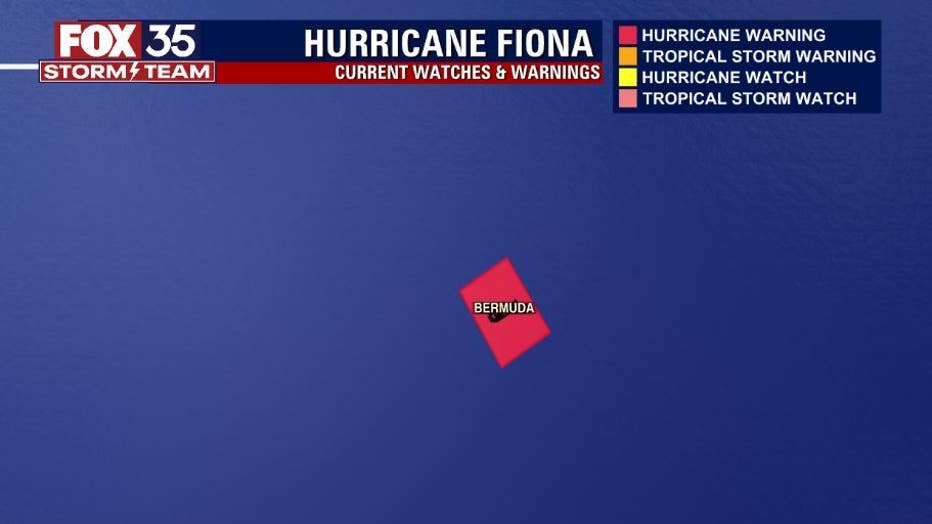
A Hurricane Warning is in effect for:
- Bermuda
A Hurricane Watch is in effect for:
- Nova Scotia from Hubbards to Brule
- Prince Edward Island
- Isle-de-la-Madeleine
- Newfoundland from Parson’s Pond to Port-Aux-Basques
A Tropical Storm Watch is in effect for:
- St. Andrews New Brunswick to west of Hubbards Nova Scotia
- West of Brule Nova Scotia to Cap Madeleine Quebec
- Anticosti Island
- Johan Beetz Bay Quebec to north of Parson's Pond Newfoundland
- West Bay Labrador to Hare Bay Newfoundland
- St. Lawrence to east of Port-Aux-Basques Newfoundland
The National Hurricane Center says Fiona will pass just to the west of Bermuda tonight, approach Nova Scotia on Friday, and move across Nova Scotia and into the Gulf of St. Lawrence on Saturday.
"Little change in strength is expected through tonight. Some weakening is expected to begin on Friday, but Fiona is forecast be a large and powerful post-tropical cyclone with hurricane-force winds when it moves over Nova Scotia Friday night and Saturday."
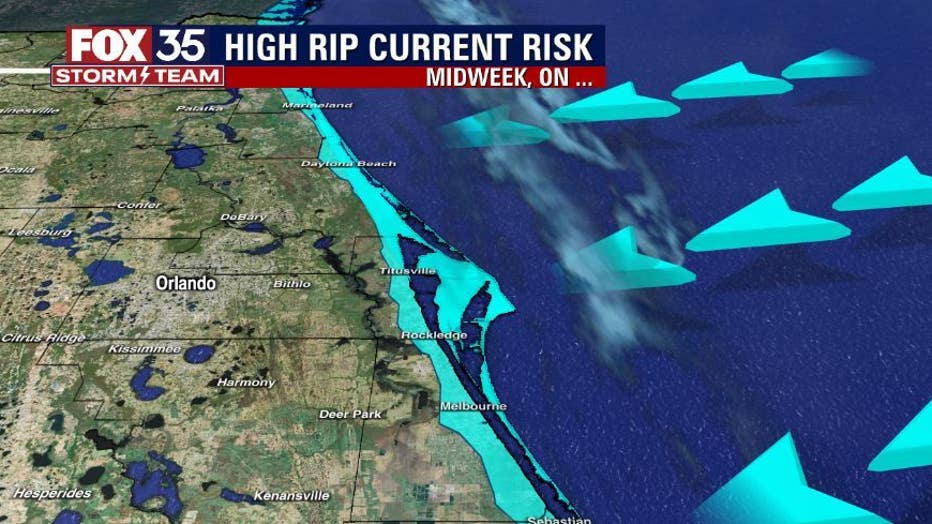
While Fiona won't have a direct impact on Florida, the system will bring rough surf to Florida beaches with waves expected to be 4 to 6 feet high. Surfers and swimmers should be cautious.
TROPICAL STORM GASTON
Gaston is located west-northwest of Faial Island in the Central Azores with maximum sustained winds of 65 mph.
"A turn to the east is expected by tonight, and a slower southeastern or southward motion is forecast by early Saturday," the NHC said. "On the forecast track, the center of Gaston will move near or over portions of the Azores on Friday. Gradual weakening is expected over the next few days."
Gaston is not expected to be any threat to Florida.
Stay with the FOX 35 Storm Team for updates throughout hurricane season, which ends Nov. 30.