

Orlando weather: Afternoon storms, cold front
Orlando PM Weather Forecast: Clear, dry, prescribed burns
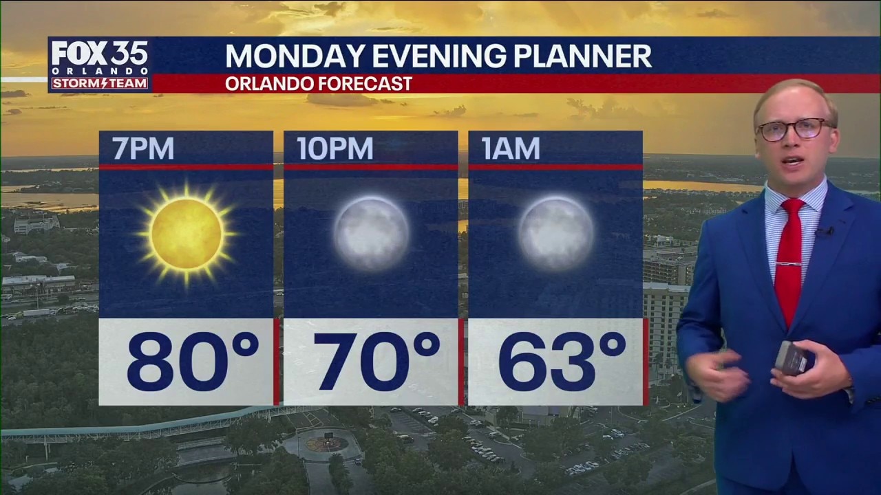
A clear dry night is expected for the evening of March 23. Multiple prescribed burns were seen on the radar -- which is spreading smoke through Central Florida. Brevard County remains under a burn ban.
ORLANDO, Fla. - Residents across Central Florida are seeing a hazy start to the week as prescribed burns send plumes of smoke and ash across several counties. While the evening promises comfortable conditions, a shift in the weather pattern is expected to bring a round of strong storms to the region on Tuesday.
Tonight: Smoke, Ash, and Cooling Temps
Heavy smoke and falling ash were reported throughout Seminole, Osceola, and Brevard counties this evening. These conditions are the result of several large-scale prescribed burns designed to manage fuel loads amid the state's ongoing drought.
Read: What's on fire? Smoke, ash over Seminole County due to prescribed burn in Lake County, officials say
Despite the haze, the overnight weather will remain pleasant. Temperatures are expected to fall to near 60 degrees under mostly clear skies, providing a brief window of calm before the next system arrives.
Forecast: Thunderstorms possible Tuesday afternoon. Here's where, when
FOX 35 meteorologist Noah Bergren said thunderstorms are possible Tuesday afternoon in Central Florida and along the Atlantic Coast. Here's the latest forecast and potential timing.
Moderate rip current risk
By Tuesday night, a moderate rip current risk stretched along the Florida coastline. This could create difficult swimming conditions for beach-goers this week, but FOX 35's Noah Bergren anticipated the dangerous tides will lessen throughout the week.
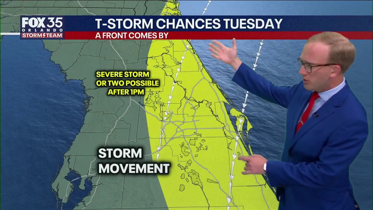
Tuesday: Afternoon storms and severe risk
Starting with pleasant morning hours on Tuesday will soon turn to increasing cloud cover by the afternoon. Meteorologists are tracking a cold front dropping south from Georgia, which is set to trigger widespread showers and thunderstorms across Central Florida in the afternoon and evening.
Key Hazards to Watch:
Storm Movement: Most activity will move toward the South or Southwest.
Severe Potential: While a low chance, one or two storms could turn severe or briefly rotate. We will monitor close in case anything gets perky on the radar Tuesday afternoon and update as needed.
Storms and showers: Storms and showers will move to the S or SW, and it's possible one or two are strong-severe. If any storms "train" and track slowly repeatedly over the same areas, locally heavy rain totals are possible.
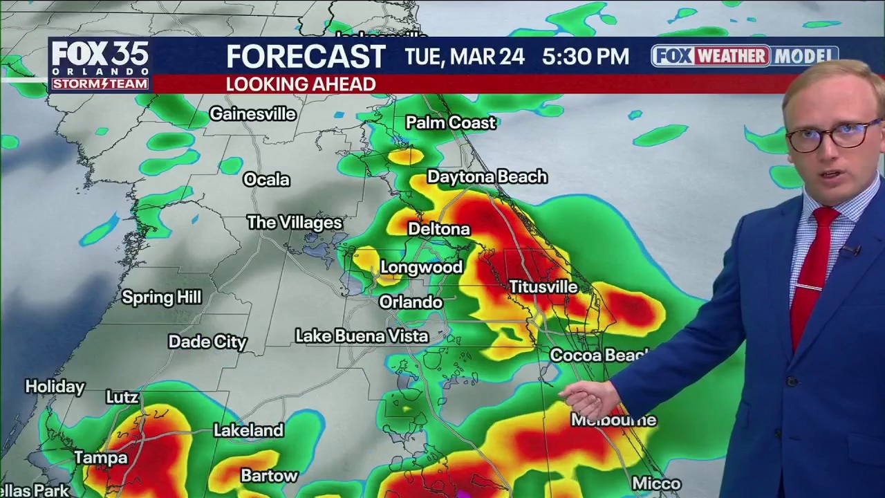
Orlando Weather Forecast: Tracking Tuesday storms
Warm and dry weather giving way to PM storms Tuesday, a few could be on the strong side in central Florida. When and where the storms track, and more with FOX 35 Storm Team Senior Meteorologist Noah Bergren.
Looking Ahead: A warm weekend
Wednesday: Expect the weather to be partly to mostly cloudy with some showers possible coming in from the Atlantic Ocean, and moving west. It does not look like a major number of showers, but sporadic showers from time to time.
Thursday & Friday: Brighter, nicer weather returns. Highs will climb back into the 80s with a good deal of sunshine.
The weekend: Another front will impact Florida this weekend with gusty winds (20+ MPH) and a few showers.

By early next week, a noticeable cooldown will follow the weekend front, with afternoon highs struggling to reach the mid-70s.
The Source: Information in this story was gathered from FOX 35's Noah Bergren.