

Orlando Weather: Severe storm threat to bring heavy rain, lightning, gusty winds and hail

Orlando PM Weather Forecast: May 10, 2025
Watching some storms flare up this evening. Another round of storms is on tap tomorrow for Mother's Day. FOX 35 Meteorologist Laurel Blanchard times out the storms and when rain could move in on Mother's Day.
ORLANDO, Fla. - The FOX 35 Storm Team has issued a series of Impact Days as a strong storm system aims to bring heavy rain, lightning, gusty winds and hail throughout Central Florida for Mother's Day weekend.
Currently, a ground stop has been issued at the Orlando International Aiprort (MCO) due to the thunderstorms. The ground stop is expected to remain in place through 7 p.m.
Here's what you need to know about the weather and how you can prepare.
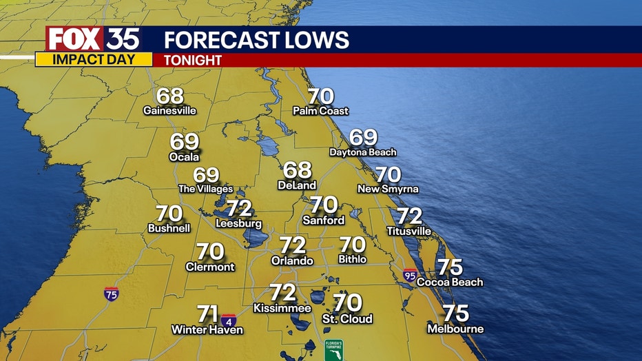
What will the weather look like tonight?
What To Expect:
The unsettled pattern across the region continues today. It's the first of a series of Impact Days as a storm system to our west continues to inch closer to us. The entire region is under a marginal risk level 1/5 chance of severe weather.
Today's threat of showers and storms really comes from the sea breeze though, just like what we've seen much of this week.

FOX 35 Weather Extra May 10, 2025: 4 p.m. update
The FOX 35 Storm Team has issued a series of Impact Days as a strong storm system aims to bring heavy rain, lightning, gusty winds and hail throughout Central Florida for Mother's Day weekend. FOX 35 Storm Team Meteorologist Laurel Blanchard brings us the latest updates at 4 p.m.
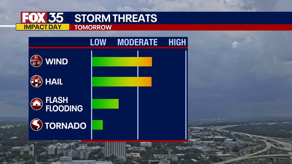
The main threats are gusty winds reaching 50 mph, as well as the possibility of some large hail. Heavy downpours across the region could lead to limited road visibility.
A severe thunderstorm warning has been issued for Marion and Alachua counties around 4:55 p.m., with the main threats being gusty winds at about 45 mph and small hail.
However, showers and storms should taper off later tonight. Lows will bottom out in the upper 60s and lower 70s with muggy conditions through the overnight.
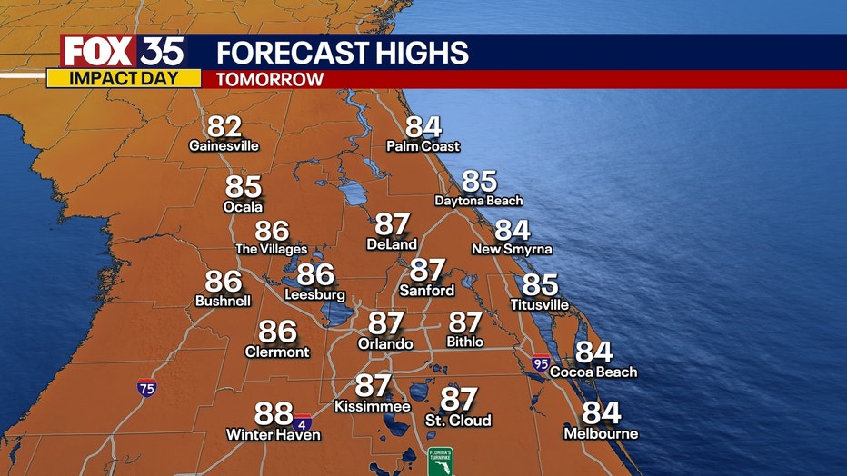
What will the weather look like for Mother's Day?
What's next:
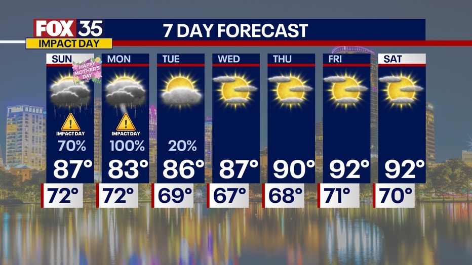
Sunday will essentially be a rise and repeat of Saturday's forecast with more widespread showers and storms through the afternoon.
The morning looks dry in most areas, so breakfast with mom or any mother figures tomorrow looks good.

It's once the sea breezes get going in the afternoon that storms will start to fire up.
The rest of the day will be soggy and stormy, so if you have any dinner plans with mom, make sure they are inside.
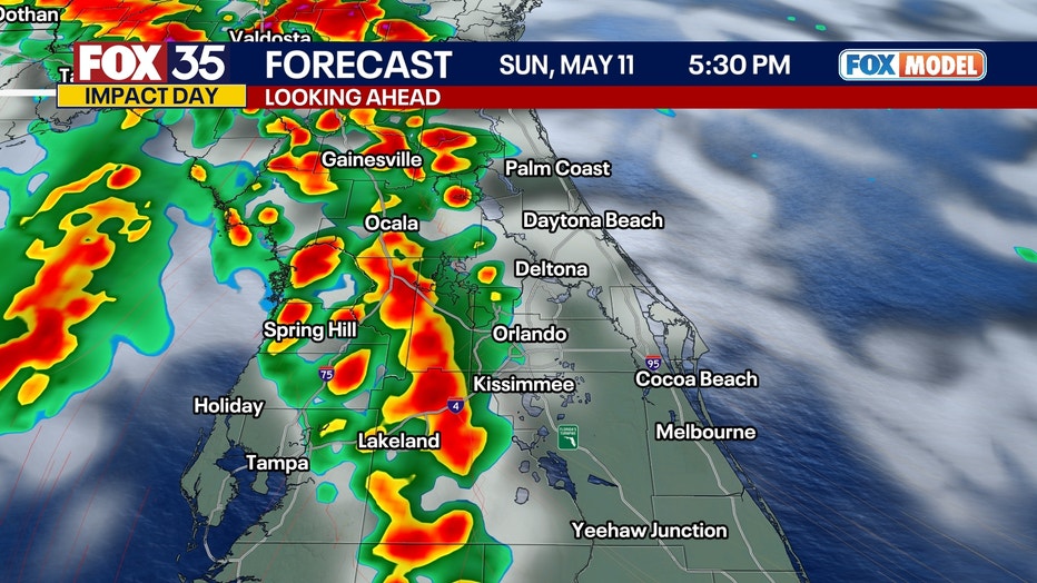
We will see storms pop up in the central part of the peninsula as the sea breezes collide.
Once again, the entire region is under a marginal risk level 1/5 chance of severe weather.
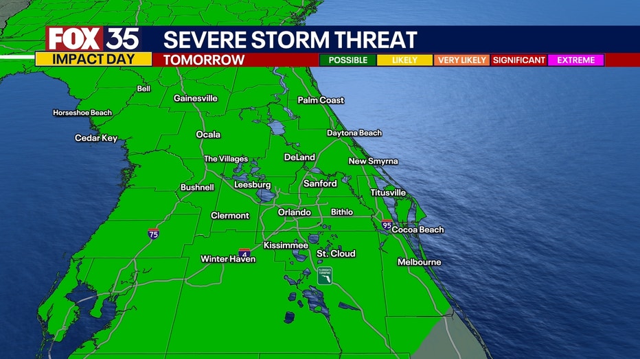
This means there could be an isolated severe storm or multiple stronger thunderstorms for the rest of the afternoon.
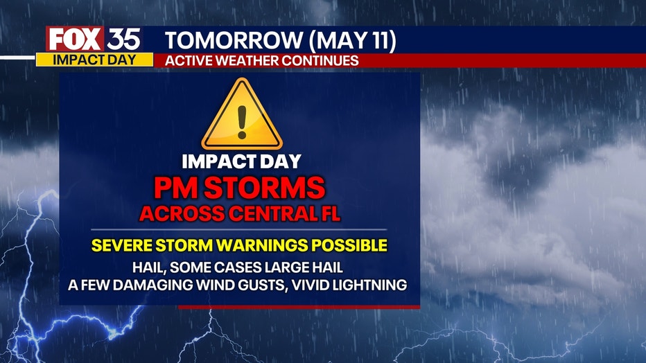
The main threats are gusty winds reaching 50 mph, as well as the possibility of some large hail. Heavy downpours across the region could lead to limited road visibility.
This is why we are calling for another FOX 35 Impact Day.
Highs rise back into the middle and upper 80s.
Showers and storms will linger through Sunday night but will quiet down as this area of low pressure across the gulf shifts east.
What will the weather look like next week?
Dig deeper:
This storm system will essentially be overhead on Monday, making it our third Impact Day of the week.
Because of the wind shear in the atmosphere, all forms of severe weather will be on the table. This includes hail and gusty winds, as well as a brief tornado or two.
This will also be an all-day event impacting the morning and evening commuters and limiting visibility due to the rain.
Highs will be closer to 80 degrees with the rain and clouds.
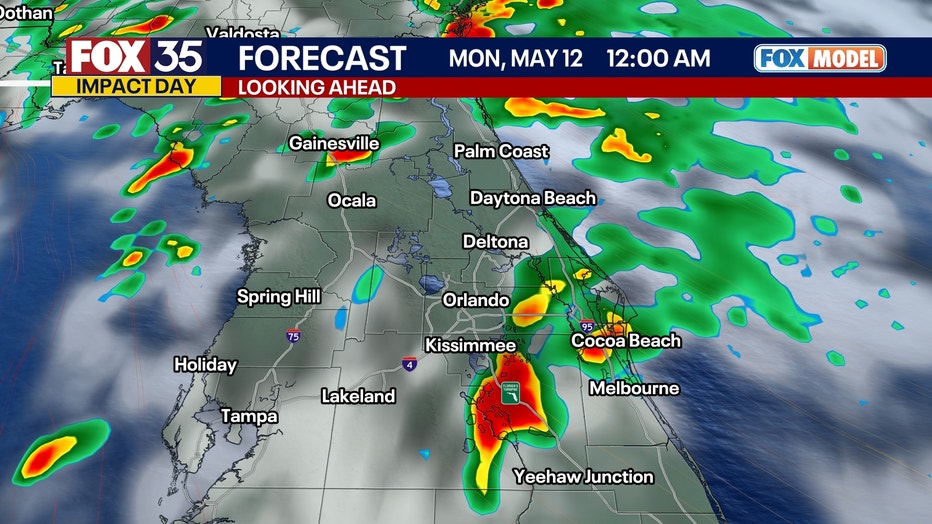
This system starts to move out on Tuesday, but there may still be a lingering shower or two.
After this, our weather gets much better and calmer with sunshine and warm temperatures back in the forecast for the rest of the week.
We are looking at highs in the 90s and lots of sunshine!
Orlando 7-Day Weather Forecast

FOX 35 Storm Tracker Radar and Live Weather Cameras
Track live when storms move across your area using the FOX 35 Storm Tracker Radar below. You can also watch as heavy rain moves across Central Florida on our Live Weather Cameras' page here.
More radar maps from FOX 35 Storm Tracker Radar
- Brevard County
- Flagler County
- Marion County
- Osceola County
- Orange County
- Polk County
- Seminole County
- Sumter County
- Volusia County
- U.S./National Radar
STAY CONNECTED WITH FOX 35 ORLANDO:
- Download the FOX Local app for breaking news alerts, the latest news headlines
- Download the FOX 35 Storm Team Weather app for weather alerts & radar
- Sign up for FOX 35's daily newsletter for the latest morning headlines
- FOX Local: Stream FOX 35 newscasts, FOX 35 News+, Central Florida Eats on your smart TV
The Source: This story was written based on information shared by the FOX 35 Storm Team on May 10, 2025.