

Live Radar: Severe storm forecast, timeline, main impacts
ORLANDO, Fla. - Wednesday is a FOX 35 Weather Impact Day as there is a decent chance for thunderstorms and showers across parts of Central Florida. Before the storms arrive, a big takeaway will be the warm and windy conditions as you get out the door.
Here is what to know about the latest weather forecast, timeline, and potential impacts.
Severe Weather Alert
A Severe Thunderstorm Warning has been issued for Volusia County until 1:45p.m.
FOX 35 Storm Tracker Radar
Track live when storms move across your area using the FOX 35 Storm Tracker Radar below.

Wednesday forecast: Strong winds and chance of storms
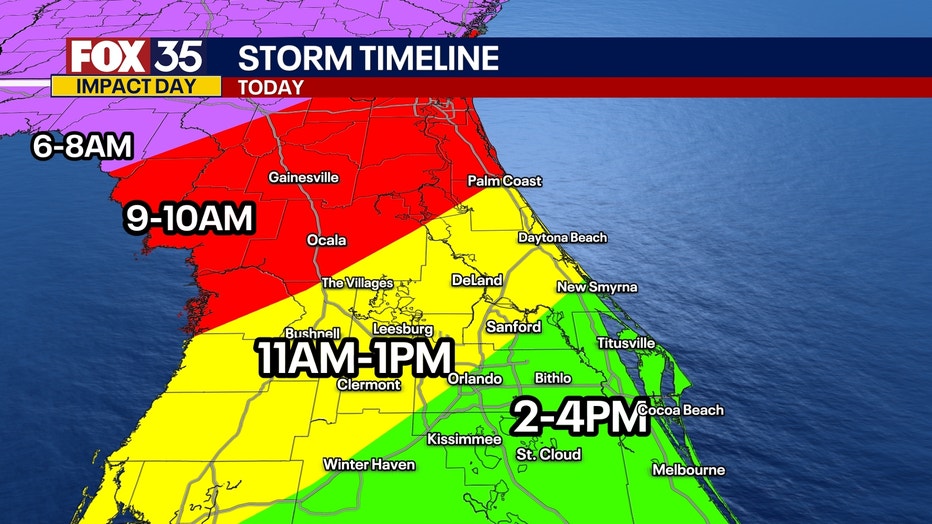
Timeline:
It is looking to be a windy and potentially rainy day in Central Florida on Wednesday. There is a chance some of the showers and storms could become severe.
A Wind Advisory is in effect for all of Central Florida from 9 a.m. to 5 p.m., with wind gusts reaching up to 40 mph or higher. Be sure to secure any outdoor furniture or loose items!
These warm southerly winds will help give a big boost to our temperatures, with highs reaching the upper 70s and low 80s.
When will the rain most likely arrive?
The best rain and storms chances are between 11 a.m. and 5 p.m. for most of Brevard, Lake, Orange, Osceola, Seminole and Volusia counties.
- North Florida/Panhandle: 6 a.m. - 8 a.m.
- Gainesville/Ocala: 9 a.m. - 10 a.m.
- Leesburg, DeLand, The Villages: 11 a.m. - 1 p.m.
- Orlando, Kissimmee, Winter Haven: 2 p.m. - 4 p.m.
Main weather threats:
The main impacts of any strong storms will be damaging wind gusts (45-55 mph), heavy rain and ponding on roads, small hail, and the low risk of a tornado or two.
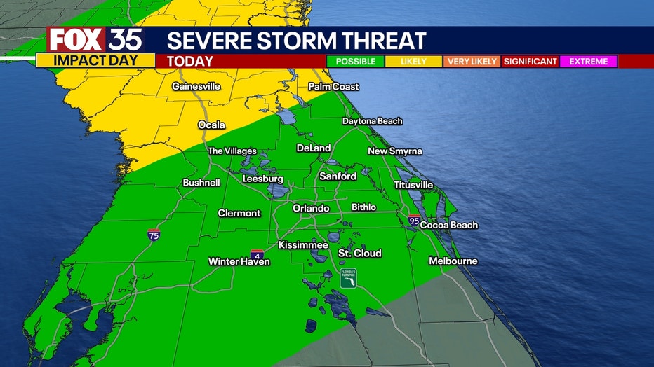
Severe weather forecast: How likely?
Areas to the northwest of I-4 will have the best chances of seeing a narrow band of any robust storms, as the system looks to fall apart rather quickly almost as soon as it reaches the Orlando Metro and the I-4 corridor.
What is causing the stormy weather?
A strong cold front moving in from the northwest will help to bring showers and storms to Central Florida as early as 10 a.m. - 11 a.m. Our ingredients won't be quite as favorable or ripe for widespread severe weather like areas further to the north. We'll be on the tail end of this system as a whole, so only a brief window of a few isolated strong to severe storms exists.
When will the stormy weather leave Central Florida?
The system looks to move in and out rather quickly, with most of Central Florida drying out before sunset.
More radar maps from FOX 35 Storm Tracker Radar
- Brevard County
- Flagler County
- Lake County
- Marion County
- Osceola County
- Orange County
- Polk County
- Seminole County
- Sumter County
- Volusia County
- U.S./National Radar
Stay connected with FOX 35
- Download the FOX 35 News app for latest news, weather, and traffic alerts
- Download the FOX 35 Storm Team Weather app for live, interactive radar
- Visit FOX35Orlando.com/weather for interactive radar, plus updated weather graphics, maps, and images
The Source: This story was written based on information shared by the FOX 35 Storm Team on March 5, 2025.