Orlando weather forecast: High humidity Tuesday with increased showers along coast

Weather Forecast: August 15, 2022
Orlando and Central Florida will see higher humidity levels over the next few days. Rain chances are low on Tuesday except along the Atlantic Coast. By mid-week, a larger part of the FOX 35 viewing area could see rain chances increase.
ORLANDO, Fla. - WHAT IS THE WEATHER FORECAST FOR TODAY AROUND ORLANDO?
Tonight’s low: 77 degrees
Tomorrow's high: 95 degrees
MAIN WEATHER CONCERNS:
Storms will pop up after lunch on Tuesday with frequent lightning and gusty winds over 50 mph. These storms will track eastward and have no trouble reaching the beaches. Otherwise, the westerly flow means big humidity, ("swamp flow"), making a return Tuesday and lasting all week long.
WHAT IS THE WEATHER FORECAST FOR WALT DISNEY WORLD, UNIVERSAL, AND SEAWORLD?
Another muggy day with scattered storms through the afternoon hours. Rain could be very heavy at times so watch that radar! Highs will climb to the low-90s so make sure you stay hydrated. When thunder roars, go indoors.
WHAT IS THE WEATHER FORECAST FOR THE BEACHES IN CENTRAL FLORIDA?
Temperatures will reach the upper 80s to low 90s with strong sun. There will be a 30% chance of afternoon storms at the beaches. Waves 1-2 feet, Winds westerly in the morning, shifting to a sea breeze southeast, onshore wind at 15mph. Moderate risk for rip currents.
LOOKING AHEAD:
It'll remain quite humid and become increasingly stormier each afternoon this work week. We may catch a break in the action this weekend as far as daily widespread storms. Depend on the FOX 35 Storm Team and download the FOX 35 Storm Team App!
TROPICS:
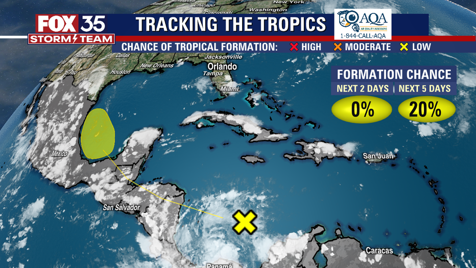
A tropical wave in the southern Caribbean Sea is expected to drift northwest, toward the Bay of Campeche and could become a tropical depression or tropical storm in that region of the southwest Gulf of Mexico. No threats to Florida anticipiated as the circulation would likely drift into Mexico or Texas
A friendly reminder, the peak of hurricane season is on September 10th, so stay alert and depend on the FOX 35 Storm Team.