

Orlando weather: Chilly weather overnight under clear skies
Orlando PM Weather Forecast: November 3, 2025
Another chilly night is on the docket across Central Florida. Meteorologist T.J. Springer tells us how long the cooler air sticks around before temperatures rebound. Tune in for that and when we could see a little more rain.
ORLANDO, Fla. - It's been a beautiful day in Central Florida in the wake of a cold frontal passage this morning.
Now that it's through, the chill is setting in once again.
Tonight's forecast
What To Expect:
Overnight lows for our NW locales look to slide back into the middle to upper 40s! Be sure to grab an extra layer if you're heading out early on. Closer to the metro, temperatures will still be cool, falling back into the middle to upper 50s.

The starry sky and light wind will help our temperatures tumble.
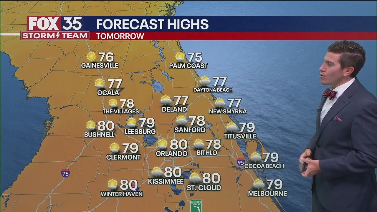
What will the weather be like on Tuesday?
What To Expect:
High pressure keeps its hold over the region on Tuesday. That means more sunshine with just a few clouds from time to time. Highs will start to rebound little by little, with afternoon readings topping out close to normal for this time of year, which is around 81 degrees.

Most of us will top out near 80 with some of our northern neighborhoods still stuck in the upper 70s. As high pressure shifts east, that'll give us more of an onshore wind.
That helps bring us a little more cloud cover into Tuesday night. Temperatures won't be as chilly with lows in the lower 60s.
Scattered showers possible later in the week
Looking Ahead:
A weak disturbance looks to move up from the south midweek and that helps bring us the slim chance of a few showers.
Chances are only around 20%. Highs warm up just a touch more, topping out in the lower 80s. A spotty sprinkle is still possible on Thursday with a bit of "energy" still upstairs in the atmosphere. This stalled front to our south continues to lift northward on Friday as a warm front and that also brings the chance for a shower or two.
Temperatures continue to rise as a result, topping out just a bit above average (lower 80s).

Temperatures continue to rise as a result, topping out just a bit above average (lower 80s). We're expecting readings in the middle 80s Friday and Saturday ahead of our next storm system, which is slated to arrive on Sunday. It looks to bring a few showers for the latter half of our weekend.

Behind this system, we'll feel another punch of cooler air as we progress into early next week.
A note for beachgoers
The Beaver Moon is our next full moon and our next Supermoon. It'll shine bright in the sky on November 5th.

This will bring more king tides. This episode of high tides will be the highest of 2025. On Nov. 6 (Thursday) the tides will be about 7 ft high, causing rough surf, beach erosion and a high risk of life-threatening rip currents.


The Source: This story was written based off of information from the FOX 35 Storm Team.