

Tropical Depression 3 expected to strengthen into Hurricane Bret, NHC says

Hurricane Bret expected to form this week
The National Hurricane Center is monitoring a tropical wave and a tropical depression in the Atlantic Ocean. The latter is expected to reach hurricane status by Wednesday. Here's what we know about both storms.
The National Hurricane Center is monitoring a tropical wave and a tropical depression in the Atlantic Ocean. The latter is expected to reach hurricane status by Wednesday. Here's what we know about both storms:
Tropical Depression 3
Tropical Depression 3, formerly known as Invest 92-L, formed in the central Tropical Atlantic on Monday morning, according to the NHC. It's expected to strengthen into a Category 1 storm by Wednesday night, the latest forecast track shows. The next storm name on the board is Bret.
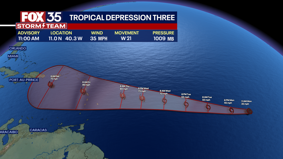
"The depression is forecast to strengthen and move across the Lesser Antilles as a hurricane on Thursday and Friday, bringing a risk of flooding from heavy rainfall, hurricane-force winds, and dangerous storm surge and waves," the NHC said in an advisory Monday morning.
See spaghetti models for Tropical Depression 3 below:
Where is Tropical Depression 3?
The system is located about 1,425 miles east of the southern windward islands and is moving toward the west at 21 mph. That motion is expected to continue over the next several days.
It currently has maximum sustained winds of 35 mph and a minimum central pressure of 1009 mb.

RELATED: Here are the 2023 Atlantic hurricane season names
Invest 93-L
A tropical wave, known as Invest 93-L, is producing showers and thunderstorms several hundred miles south of the Cabo Verde Islands.
Forecasters said it could develop into a tropical depression over the next few days as the system moves westward at 10 to 15 mph across the eastern and central tropical Atlantic.

We will keep monitoring trends so keep with us! Depend on the FOX 35 Storm Team for your tropical updates.