

Hurricane Ian downgrades to tropical storm as it batters Florida with storm surge, flooding
TAMPA, Fla. - FOX 13's newscast is being simulcast on the following radio stations: Hot 101.5, 97x (101.5 HD2), and 102.5 The Bone with occasional coverage.
Hurricane Ian continues to weaken and is now a tropical storm as it continues to move across the Florida peninsula, bringing storm surge, winds and flooding.
The storm made landfall Wednesday afternoon on an already soaked Sanibel Island and Captiva Island in Southwest Florida.
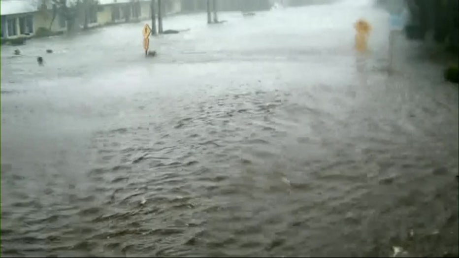
Flooding on Sanibel Island (City of Sanibel)
Heavy flooding occurred hours before the center of Ian's eye arrived on the small islands, which are popular beach destinations.
A view from the city's live cameras shows water levels reached the windows of a building and the bottom of street signs.

Watch storm chasers try to stand in 150mph winds in Southwest Florida
Video from Joel Franco shows storm chasers and weather reporters on the street in Punta Gorda as the storm blew through. At one point, a quick-moving tree branch trips up meteorologist Jim Cantore. Courtesy Storyful
MORE: Tree branch hits Jim Cantore during Hurricane Ian report: 'Just give me a minute'
As Ian moves across the Florida peninsula, coastal areas were still being inundated with storm surge, winds and flooding, according to the National Hurricane Center.
Inland residents living in DeSoto, Hardee, Highlands, and Polk counties were in for a long night as the storm moved over Central Florida.
Hurricane Ian is expected to move into the Atlantic on Thursday, but not before dumping upwards of 20" of rain across the I-4 corridor.

Polk County braces for long night as Ian moves inland
Some of Hurricane Ian's worst inland impacts will be felt after nightfall in Polk County.
Governor Ron DeSantis said during a 5:30 p.m. Wednesday update on Hurricane Ian that while they have received reports of structural damage, the major issue has been the storm surge and flooding.
The storm is expected to continue moving through the state, causing damage along the way.
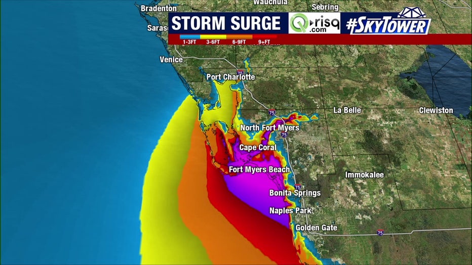
Hurricane Ian storm surge projections
Evacuation orders, school closures, and incredibly last-minute preparations began Tuesday after Ian’s track continued shifting east, signaling a landfall in southwest Florida.
Those living in Sarasota and Charlotte counties were caught off-guard. Storm surge predictions nearly doubled, swapping forecasts with Tampa Bay.
For days, the National Hurricane Center had emphasized the high uncertainty when it came to Ian’s forecast as it approached the west coast of Florida.
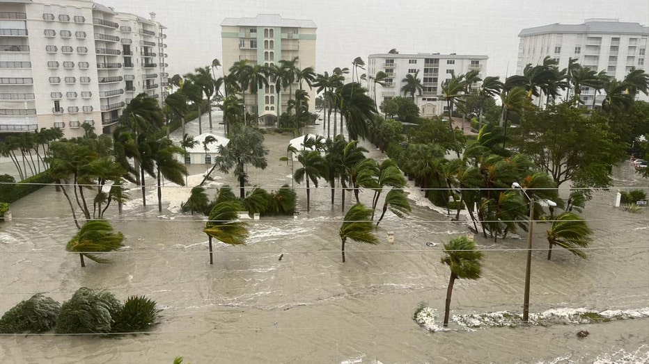
Flooding in Naples (Credit: City of Naples)
Tracking Hurricane Ian
Tuesday, Ian underwent an eyewall replacement cycle. It's a weakening process that usually takes about 24 hours, but it appeared to be completed sooner than that. Wednesday morning, it showed signs of intensifying, and it has time to strengthen before making landfall. Its eye is about 30 miles wide.

Timelapse: Water pulled out of Tampa Bay at Bayshore Boulevard
This timelapse video shows Tampa Bay draining as Hurricane Ian marched up the west coast of Florida.
READ: Why is the right side of a hurricane more dangerous?
A few days ago, forecasters said it could stall out, but on its current projected path, Ian will continue moving forward over central Florida between Wednesday night and Thursday morning before emerging over the western Atlantic by late Thursday.
As the major hurricane closed in, winds began picking up after midnight in the Tampa Bay region with wind speeds reaching 25 mph. Tropical-storm-force winds will continue to be around for more of Wednesday.
MORE: Here's how the 'Waffle House Index' measures a hurricane's potential impact
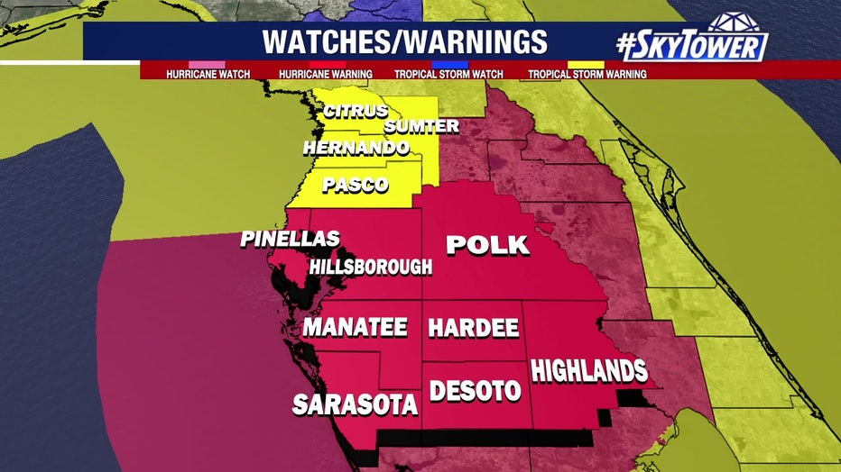
Hurricane Ian watches and warnings on September 28, 2022.
Long-time Floridians have been comparing Charley’s path to Ian’s forecast. But both storms are, otherwise, different. Ian’s eye is about 30 miles wide following a replacement cycle. Hurricane-force winds extend 45 miles outside the center of Ian. Tropical-storm-force winds extend 170 miles out.
In comparison, Charley’s eye was about 5 miles wide at the time of its landfall in 2004.

Ian's eyewall compared to Hurricane Charley's eyewall
This comparison of the size of Ian's eyewall to the size of Charley's when it made landfall in the same area back in 2004 shows how dangerous this storm is.
"This is why we don't compare storm to storm because this one is a much bigger, much stronger impact in southwest Florida," Osterberg said. "This is the problem too, anytime a storm enters the Gulf, it has to go somewhere. Unfortunately, that somewhere is probably going to be, say, the Fort Myers area with this particular storm. Thirty-six hours ago, the models were saying this was coming straight through Tampa Bay and, again, it has shifted a little bit east and to the south, which does spare us some."

Lightning flashes around eye of Hurricane Ian during landfall
Satellite video shows lightning around the eye of Hurricane Ian as it made landfall near Fort Myers as a Category 4 storm, with 157 mile-per-hour winds.
Roughly two million power outages have been reported. You can monitor outages on each power company's website:
- Duke Energy - https://outagemap.duke-energy.com/#/current-outages/fl
- Florida Power & Light - https://www.fplmaps.com/
- Peace River Electric - https://www.preco.coop/services/outage-center/
- TECO - https://account.tecoenergy.com/outage/outagemap
- Lakeland Electric - https://lakelandelectric.com/storms-and-outages
- Withlacoochee River Electric - https://staticmap.wrec.net/