

Orlando weather: Tornado watch expires, severe thunderstorm warnings issued
Orlando PM Weather: Storms moving out, Cooler on Sunday
Meteorologist Laurel Blanchard breaks down the latest storms and when they will calm down and when the cooler air moves in. Will there be any more rain to wrap up the weekend? Tune in to find out!
ORLANDO, Fla. - Saturday was declared Saturday a FOX 35 Storm Alert Day because of the potential for strong or severe thunderstorms, as well as a slight tornado threat, in Orlando and Central Florida.
Click here for latest weather alerts
MAP: Tornado watch issued; county-by-county
A tornado watch had been issued for all of Central Florida, from 11 a.m. to 6 p.m. The following counties are under a tornado watch:

- Alachua
- Bradford
- Brevard
- Citrus
- Clay
- Flagler (Canceled)
- Hernando
- Hillsborough
- Lake
- Levy
- Marion (Canceled)
- Orange
- Osceola
- Pasco
- Pinellas
- Polk
- Putnam
- Seminole
- St. Johns
- Sumter (Canceled)
- Volusia
What are the biggest threats?

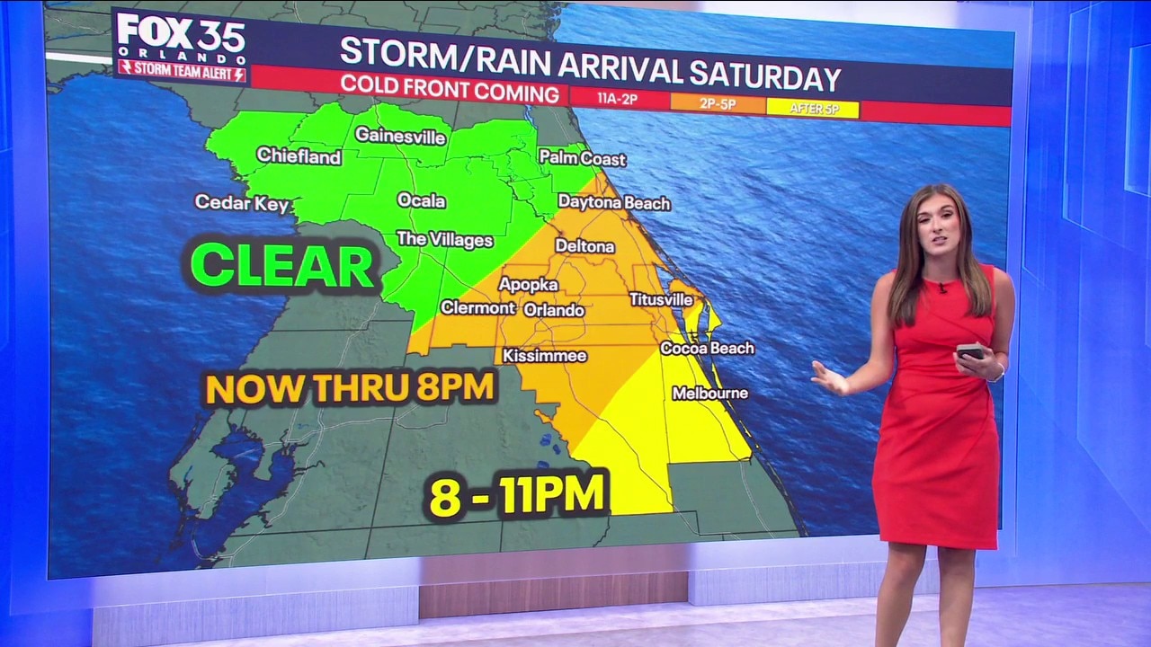
Timeline: When could the storms arrive in Orlando? When does the weather threat end?
- Gainesville/Ocala: 11 a.m. - 2 p.m.
- The Villages/Apopka/Daytona Beach: 2 p.m. - 5 p.m.
- Orlando, Kissimmee, Cocoa Beach: After 5 p.m.
These showers and storms should continue to lose their power as they shift to the southeast through sundown with just a few showers left overnight.
Highs today will be hot ahead of the front, with readings near 90. Tonight, we'll fall back into the middle to upper 60s.
What will the weather look like tomorrow?
What to Expect:
A couple of showers are still possible Sunday, mainly south of Orlando. This is thanks to the front still in the vicinity, just to our south. It'll be much cooler and less humid behind this system with temps only topping out in the upper 70s and lower 80s.
Clouds diminish from NW to SE with our northern communities seeing a bit more sun compared to our southern neighborhoods. Clearing continues Sunday night with lows dipping back into the upper 50s and lower 60s.
Looking ahead
What to Expect:
The workweek kicks off on a pleasant and comfy note with temperatures still a touch below normal. Afternoon readings look to stay in the lower 80s, combined with the still lower humidity.

It's short-lived though, as a ridge of high pressure starts to build back in. This means more heat and mainly dry conditions as we approach mid to late week.
Highs on Tuesday jump back into the middle to upper 80s with the 90s on the docket by Wednesday. The heat holds with temps parked in the lower to middle 90s Thursday and Friday ahead of yet another cold front. This one doesn't bring a great chance of rain, but we could see a few late-day downpours and storms on Friday.
The Source: The information is from the FOX 35 Storm Team and National Weather Service.