

Orlando weather: Chance of sea breeze showers, storms highlight Sunday's forecast

Orlando PM Weather Forecast: June 8, 202
More heat and humidity are on tap looking ahead to the start of the workweek. Meteorologist Laurel Blanchard lets us know how hot it'll feel and when we could see higher rain chances develop.
THIS EVENING/TONIGHT
ORLANDO, Fla. - A few splash and dash storms are on tap throughout the evening. Storms dissipate after 9pm with conditions being warm and muggy through the overnight.
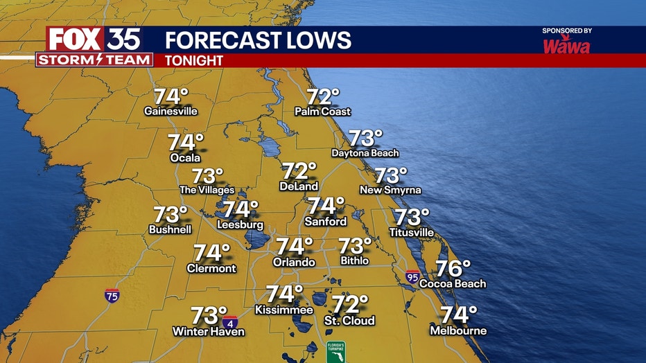
This evening we should be in for a STUNNING sunset with less clouds and the Saharan dust still lingering in the atmosphere. Temperatures for lows overnight in the low to mid 70s with mainly clear skies.
MONDAY
Take the forecast we had today and copy and paste!
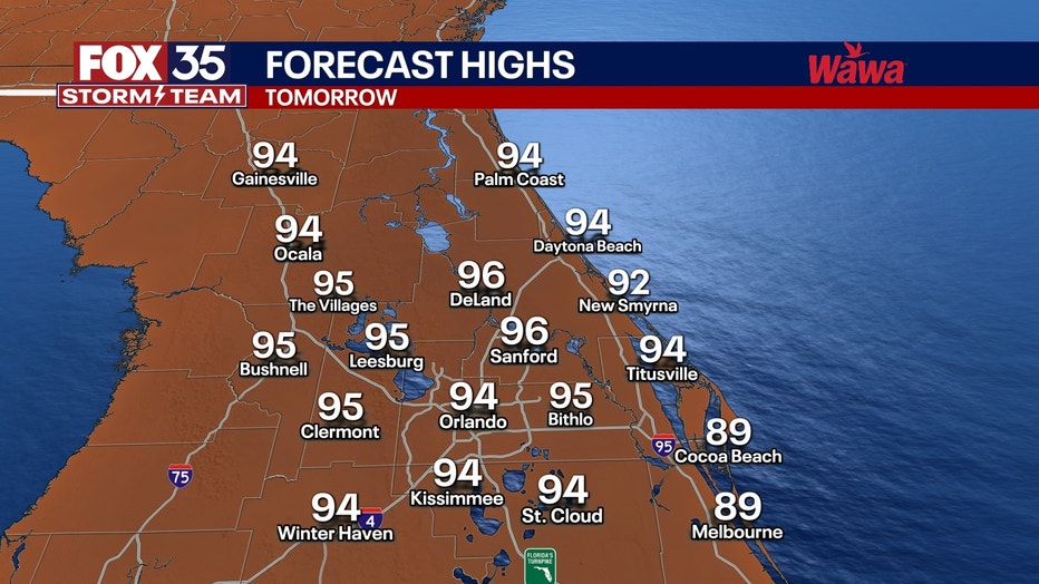
Out the door tomorrow, it will be mild and humid right off the bat with temperatures starting off in the upper 70s. Low to mid 90s on tap for your Monday with only 30% chances for a few PM thunderstorms scattered across the region. Make sure you get outside and enjoy!
Any clouds or pop-up showers that spark up in the afternoon will quickly fizzle out and clouds will clear out through the overnight. The humidity will start to kick back in tomorrow with dew points in the mid 70s. Heat indices will be in the triple digits. Mainly clear skies are forecast tomorrow night with lows falling in the low 70s.
LOOKING AHEAD
Next week, we fall right back into the daily widespread afternoon storms. It looks like the chances of rain are 60% or higher starting next Tuesday. Highs will be in the low and mid 90s most of next week.
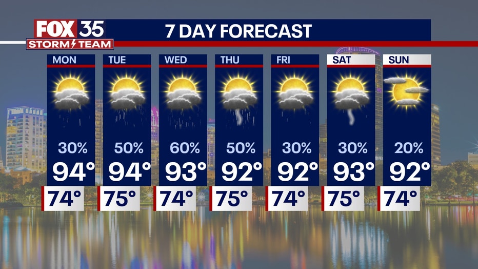
The humidity also jumps up making it feel like 100 degrees +. We keep this pattern through next weekend. The tropics remain quiet and should stay quiet for a while in the Atlantic basin due to the dust and high wind shear currently in the atmosphere.
More radar maps from FOX 35 Storm Tracker Radar
- Brevard County
- Flagler County
- Marion County
- Osceola County
- Orange County
- Polk County
- Seminole County
- Sumter County
- Volusia County
- U.S./National Radar
STAY CONNECTED WITH FOX 35 ORLANDO:
- Download the FOX Local app for breaking news alerts, the latest news headlines
- Download the FOX 35 Storm Team Weather app for weather alerts & radar
- Sign up for FOX 35's daily newsletter for the latest morning headlines
- FOX Local: Stream FOX 35 newscasts, FOX 35 News+, Central Florida Eats on your smart TV
The Source: This story was written based on information shared by the FOX 35 Storm Team on June 8, 2025.