

FOX 35 Severe Weather Alert Day Thursday: Strong thunderstorms, isolated tornado possible

Weather Forecast: March 4, 2020
FOX 35 meteorologist Jayme King gives you the latest on the weather in Central Florida.
ORLANDO, Fla. - A potent cold front will move into Florida Thursday afternoon and with it could come a round of severe weather.
A FOX 35 WEATHER ALERT DAY goes into effect Thursday afternoon with the potential for strong to severe thunderstorms across parts of the viewing area. As of right now, a SLIGHT RISK of severe storms (damaging winds and even an isolated tornado) can be found over North Central Florida. Alachua, Marion, Putnam and Flagler Counties. A MARGINAL RISK for severe stoms can be found to the South and includes nearly all of the East Central Peninsula. In this area, one can expect a chance of storms but, perhaps of less intensity and focus as areas in the SLIGHT RISK zone.


Lots of energy will be streaming in from the South all day Thursday. Temperatures will warm into the 80s and breezes increasing from the South. You can see in the forecast model graphic above, the yellow and green colors highligthing the available energy for developing storms to tap into. Much of it peaking during the warmest time of the day with all ingredients coming together for some rather strong storms.
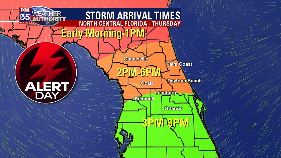
Looking at arrival times, which may need to be adjusted for a later storm arrival. As of right now, the window for strong/severe storm development appears to open around 2pm over far North Central Florida and remains open through about 6pm Thursday evening. Areas to the South can look for storm impacts between 3pm-9pm, again, updates on these arrivals will likely need to be adjusted as new data comes into the FOX 35 Weather Center.
Track the storms and stay up to date on the latest weather in Central Florida by downloading the FOX 35 Weather App.