

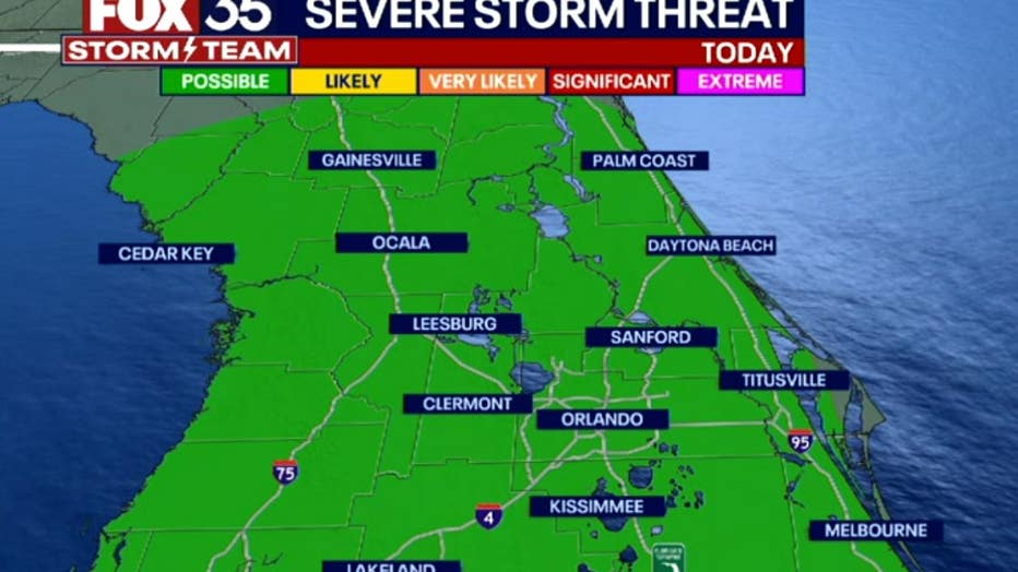
Severe thunderstorm watch issued for most of Central Florida
ORLANDO, Fla. - Strong storms started rolling into Central Florida on Saturday afternoon, prompting weather alerts for most counties.
A Severe Thunderstorm Watch is in effect for Seminole, Orange, Brevard, Sumter, Polk, and Lake counties until 8 p.m.
Saturday is a FOX 35 Weather Impact Day. FOX 35 Storm Team Meteorologist Brooks Garner says the primary threat today from thunderstorms is damaging wind gusts.
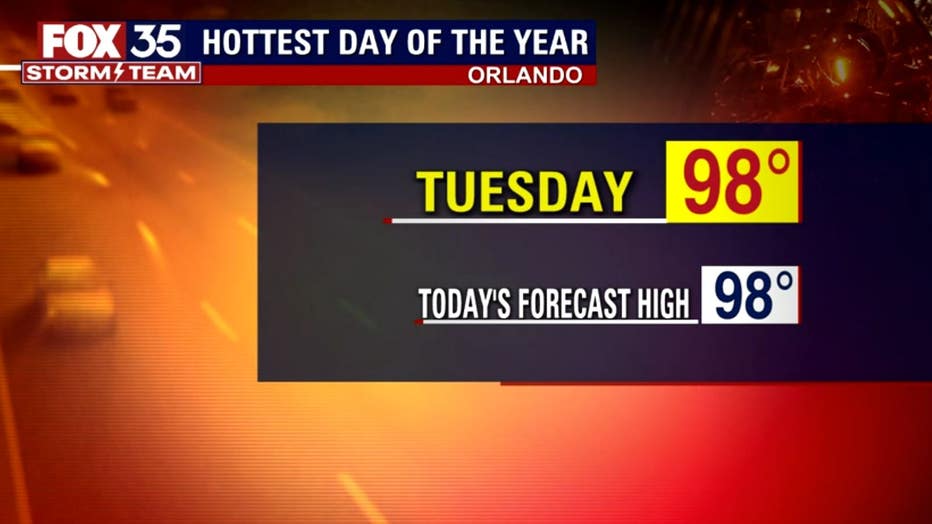
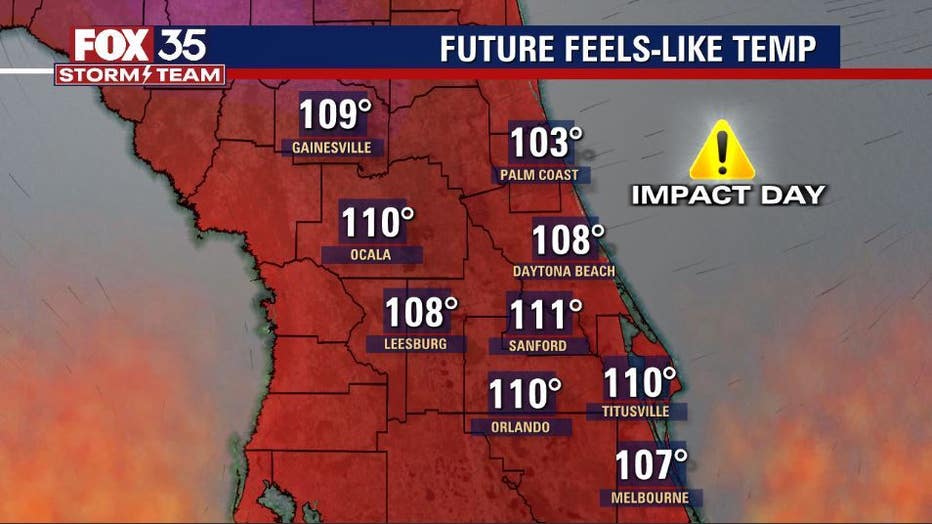
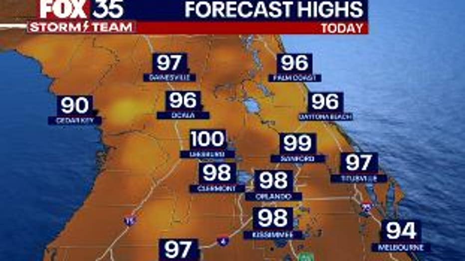
Central Florida is expected to see highs in upper 90s, but the ‘feels like’ temperatures will be between 107 - 112 degrees in some areas. Saturday is expected to tie Tuesday for the hottest day of the week with 98 as the high temperature in Orlando. Leesburg is expected to hit a high of 100-degrees even without the heat index.
If you're headed to a theme park, it will be a hot and humid day for the park goers. Temperatures will start off warm, reaching 90 by 12 p.m.
Head to the beaches early on Saturday. Mostly sunny skies along the Atlantic coastline until noon, then clouds will creep in. Rain chances will be high for the beaches with showers and thunderstorms in the afternoon. The surf will be around 2 ft and there will be a moderate risk for rip currents.
HEAT ADVISORY IN FLORIDA
A Heat Advisory is in effect for most of Central Florida from 2 - 8 p.m. Counties include Volusia, Lake, Sumter, Seminole, Orange, and Osceola.
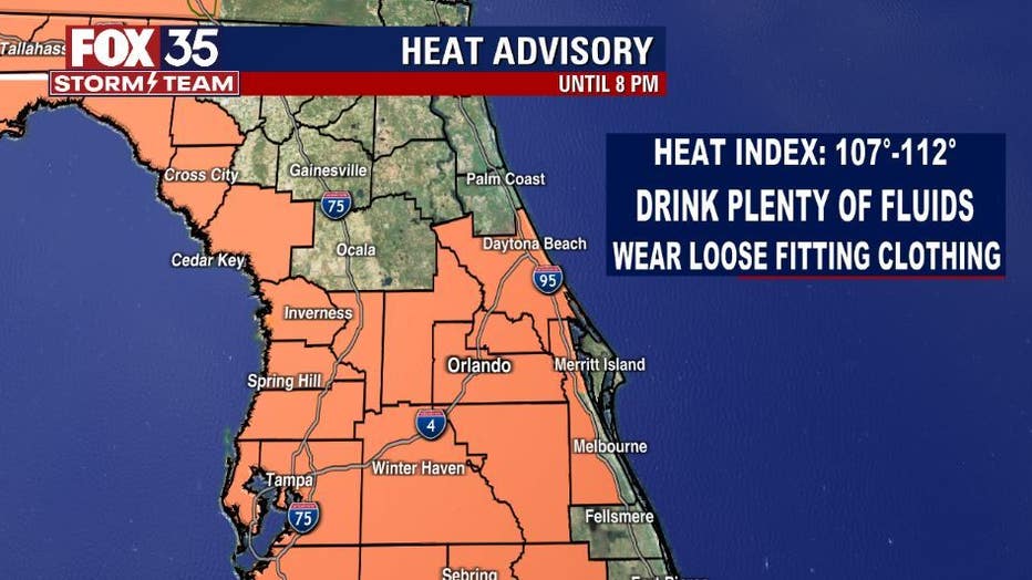
Make sure you take breaks inside the A/C, wear lightweight clothing and check on your elderly neighbors.
DOWNLOAD: FOX 35 NEWS APP | FOX 35 STORM TEAM WEATHER APP
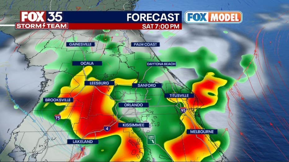
WILL IT RAIN THIS WEEKEND IN CENTRAL FLORIDA?
Storm chances are on the rise this weekend beginning around 5 p.m. on Saturday and into the evening. The rain should clear out around 10 - 11 p.m.
More rain and heat is expected on Sunday for Father's Day.
Because of the excessive heat, Seminole County officials have activated their "Extreme Weather Plan." The county's cooling centers will be at all parks and libraries throughout the county.
RELATED: Florida heat wave: These are the hours you should avoid being outdoors
HOW TO STAY COOL IN HOT WEATHER
Emergency managers say if you do plan on being outside, be sure to stay hydrated, stay in the shade as much as possible, and take breaks when you need. They've also put an emergency relief shelter on standby in case any local assisted living facilities or nursing homes lose power or air conditioning.
They say all cooling centers will have supplies and personnel who can help people looking to beat the heat. The county also has mobile conditioner units that they can bring to nursing homes that lose air conditioning and use on-site.
HOTTEST HOURS OF THE DAY
The hottest hours are between 11 a.m. and 4 p.m. so experts advise staying inside if you can and avoid taking your pets for long walks at that time, especially on asphalt or concrete.
Head to the beaches early on Saturday. Mostly sunny skies along the Atlantic coastline until noon, then clouds will creep in. Rain chances will be high for the beaches with showers and thunderstorms in the afternoon. The surf will be around 2 ft and there will be a moderate risk for rip currents.