

Severe thunderstorm warnings issued for parts of central Florida
ORLANDO, Fla. - The National Weather Service issued multiple Severe Thunderstorm Warnings Saturday afternoon for areas of east central Florida, warning of damaging winds and large hail as storms moved through the region.
4:30PM Update:
Earlier on this afternoon, storm started to fire up and become severe in Brevard county, Flagler County, and Osceola County. Reports include wind gusts up to 60 mph , reports of quarter (coin) sized hail, and extremely heavy rain.
So far this evening, eight severe thunderstorm warnings have been issued by the national weather service.
Currently, there are two severe thunderstorm warnings active:
- Eastern Osceola and south Brevard County : a severe thunderstorm warning is in effect until 5 PM. Wind gust could reach 60 mph and produce quarter size hail.
- Northeastern Lake County and central Volusia County: a severe thunderstorm warning is an effect until 5 PM. Main threats include winds up to 60 mph in quarter size hail.
Central Brevard, southeastern Orange, and northeastern Osceola counties
As of 4:03 p.m., a severe thunderstorm warning remains in effect until 4:30 p.m. for central Brevard, southeastern Orange, and northeastern Osceola counties.
A nearly stationary storm near Canaveral Groves is producing 60 mph wind gusts and quarter-size hail. Impacted locations include Rockledge, Cocoa, Cocoa Beach, Cape Canaveral, and Merritt Island.
Southeastern Orange and northeastern Osceola
At 3:45 p.m., a severe thunderstorm was reported near Canaveral Groves in central Brevard County, nearly stationary, and producing wind gusts up to 60 mph and quarter-size hail.
This warning extends to southeastern Orange and northeastern Osceola counties until 4:30 p.m. Affected areas include Titusville, Rockledge, Cocoa, Cocoa Beach, and Cape Canaveral.
Southeastern Seminole, east central Orange, and northwestern Brevard counties
What we know:
As of 3:08 p.m., a severe thunderstorm was located near Mims in northwestern Brevard County, moving southeast at 20 mph. The storm is capable of producing ping-pong ball-sized hail and wind gusts of up to 60 mph, with radar indicating the potential for significant damage to roofs, siding, trees, and vehicles.
This warning covers southeastern Seminole, east central Orange, and northwestern Brevard counties and remains in effect until 4 p.m. EDT.
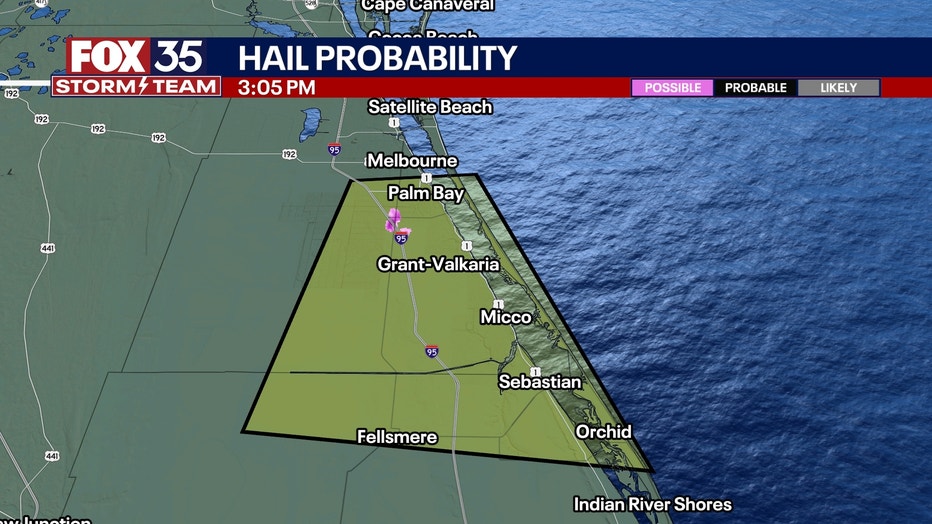
Southeastern Brevard and northeastern Indian River counties
What we know:
A second warning was issued at 3:02 p.m. for southeastern Brevard and northeastern Indian River counties, where a storm over Palm Bay was moving south at 25 mph. Radar indicated the potential for quarter-sized hail and 60 mph winds. Impacted areas include Palm Bay, Melbourne, Sebastian, Fellsmere, and Indian River Shores. That warning is in effect until 3:45 p.m. EDT.
Residents are urged to take shelter in interior rooms on the lowest floor of their homes and avoid windows during the storms.
Hail in Palm Bay
Video of hail in Palm Bay was captured around 3 p.m. by viewer Autumn Michelle and sent to FOX 35 News.

Viewer captures hailstorm in Palm Bay
Video of hail in Palm Bay was captured around 3 p.m. on May 24, 2025 by viewer Autumn Michelle and sent to FOX 35 News.
FOX 35 Storm Tracker Radar and Live Weather Cameras
Track live when storms move across your area using the FOX 35 Storm Tracker Radar below. You can also watch as heavy rain moves across Central Florida on our Live Weather Cameras' page here.
More radar maps from FOX 35 Storm Tracker Radar
- Brevard County
- Flagler County
- Marion County
- Osceola County
- Orange County
- Polk County
- Seminole County
- Sumter County
- Volusia County
- U.S./National Radar
STAY CONNECTED WITH FOX 35 ORLANDO:
- Download the FOX Local app for breaking news alerts, the latest news headlines
- Download the FOX 35 Storm Team Weather app for weather alerts & radar
- Sign up for FOX 35's daily newsletter for the latest morning headlines
- FOX Local: Stream FOX 35 newscasts, FOX 35 News+, Central Florida Eats on your smart TV
The Source: The information in this article comes from the National Weather Center and the FOX 35 Storm Team meteorologists on May 24, 2025.