

Orlando weather: Scattered storms, gusty 40MPH winds expected
Orlando PM Weather Forecast: Spotty showers, warm weekend expected
While the region saw some spotty showers – including a downpour around 5:30 p.m. in Seminole County, calm winds and clear skies are on the horizon for the weekend. Our next cold front rolls into Central Florida this weekend, sparking showers and storms later on Saturday into your Sunday morning.
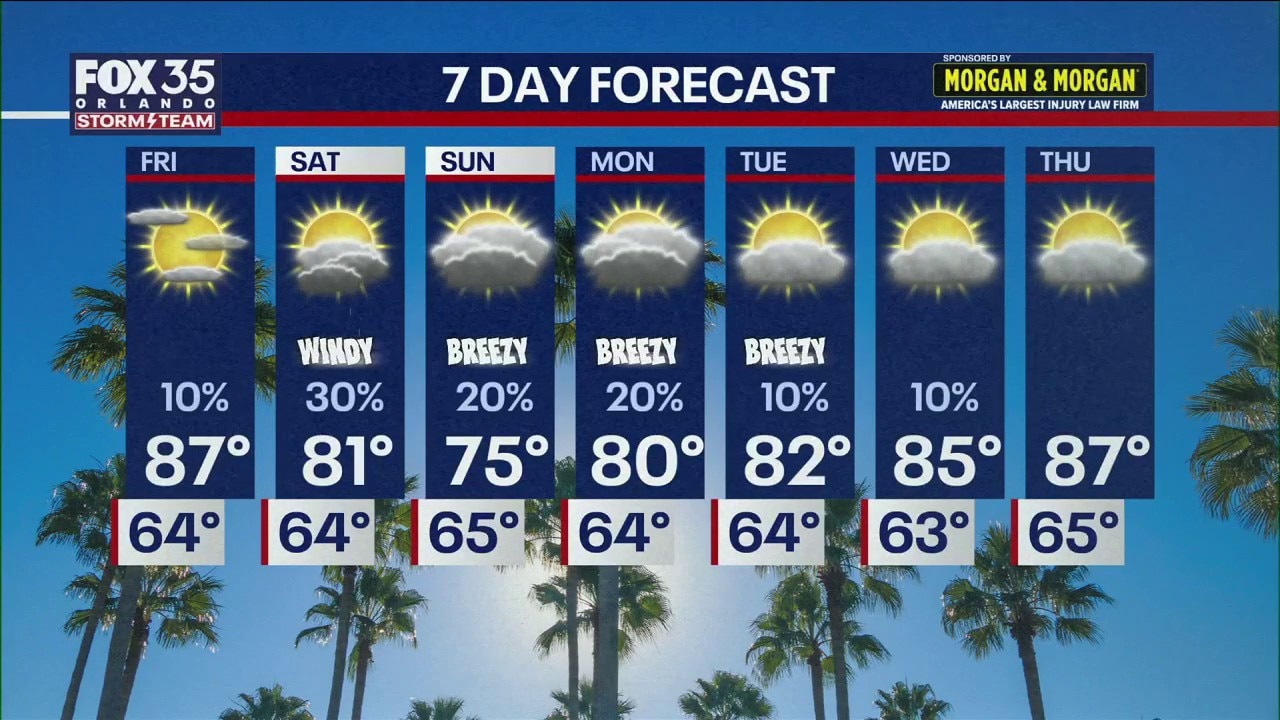
ORLANDO, Fla. - Central Florida is bracing for another oncoming cold front as temperatures this weekend swing from a summer-like heatwave on Friday to gusty thunderstorms and a localized cooldown by Sunday.
While the region saw some spotty showers – including a downpour around 5:30 p.m. in Seminole County, calm winds and clear skies are on the horizon for the weekend.
Tonight: Fog alert for the morning drive
As showers fade west of Orlando this evening, calm winds and clearing skies will create the perfect recipe for dense patchy fog, which will impact Saturday morning commutes.

Lows: Temperatures will settle comfortably in the low-to-mid 60s.
Travel Impact: Visibility may be significantly reduced late tonight and early Friday morning. Drivers on I-4 and the Florida Turnpike should allow for extra travel time.

Friday: Lots of sunshine
The Highs: Friday will be the warmest day of the stretch, with temperatures making a run at 90°F.
Conditions: Expect wall-to-wall sunshine and climbing humidity levels. If you have outdoor chores or want a beach day, Friday is the definitive "pick of the week."
Evening: Lows will stay in the 60s under mostly clear skies.

The Weekend: Storms, wind conditions
The pleasant conditions won't last long as a new weather front rolls into Central Florida starting Saturday afternoon.
Saturday: Showers
The front will spark scattered showers and thunderstorms. While it won't be a total washout, the atmosphere will turn more volatile after sunset. Those with outdoor plans are encouraged to have an umbrella and raincoat handy.
Hazard: Storms moving through Saturday night could pack gusty winds up to 40 mph.

Sunday: Breezy and Cooler
As the front pushes through, it will drag in a much cooler air mass.
Temperature Drop: Showers linger into Sunday with the cooler air moving in, dropping our temperatures from well above average on Friday to back to average temperatures for this time of year, back into the upper 70s to round out the weekend and start off next week. Conditions will still be breezy on Sunday as the cooler air moves in.
The Source: Information in this story was gathered from FOX 35's Noah Bergren and Laurel Blanchard.