

Orlando weather: Downpour of showers, storms, lightning, small hail predicted
Orlando PM Weather Forcast: Rain, storms move through Central Florida
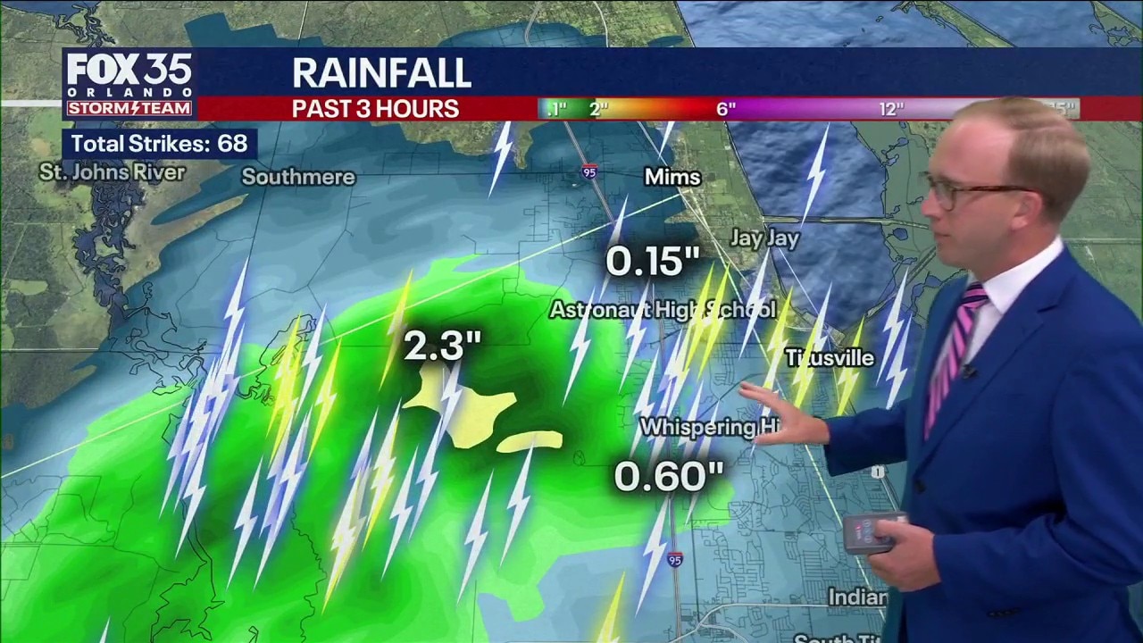
Big downpours are expected from Palm Coast to Southern Florida this evening, March 24. A rain rate is predicted to have four to five inches per hour. West Titusville had 2.3 inches of rain by 5:15 p.m.
ORLANDO, Fla. - A downpour of rain with active storms is spreading across Central Florida on Tuesday night. The "big stuff" is expected to taper off tonight, in which residents should prepare for a noticeable shift in the weather heading into Wednesday.
Tonight: Tracking gusty winds and small hail
The National Weather Service and local radar are tracking a cluster of storms producing gusty winds, frequent lightning and small hail. The primary concern this evening remains high wind gusts: a 50 mph gust was recorded near St. Cloud at approximately 5:47 p.m. EDT.

Timeline: Expect the most intense activity to conclude by 9:00 p.m.
Overnight: While the main front moves through, a few stray showers may redevelop in the early morning hours of Wednesday.

Wednesday: A cooler, breezy day
Following the passage of a cold front overnight, Wednesday will feel significantly different.
Those in Central Florida can expect a cooler and breezy day with mostly cloudy conditions and a northeast wind at 10 to15 mph.

Possible showers?
A few passing showers are possible at any point of the day.
According to radar projections, storms and showers will move to the west. It's possible one or two storms will produce lightning.

Looking ahead: A great deal of sunshine
Thursday & Friday: Temperatures will get back into the 80s with a good deal of sunshine. Friday, in particular, may make it into the upper 80s with lots of sunshine!
The weekend: The pleasant break will be short-lived. Another weather front is timed to impact Florida this weekend.
Saturday/Sunday: Expect afternoon and evening rounds of rain and storms starting Saturday and lasting into early Sunday morning.
Early next week: Starting Sunday, it will turn gusty and cooler. Brisk easterly winds, between 15 to 30 mph, will settle in, lasting through the start of next week.
The Source: Information in this story was gathered by FOX 35's Noah Bergren.