

Orlando weather: Freeze warnings in effect before major warming trend
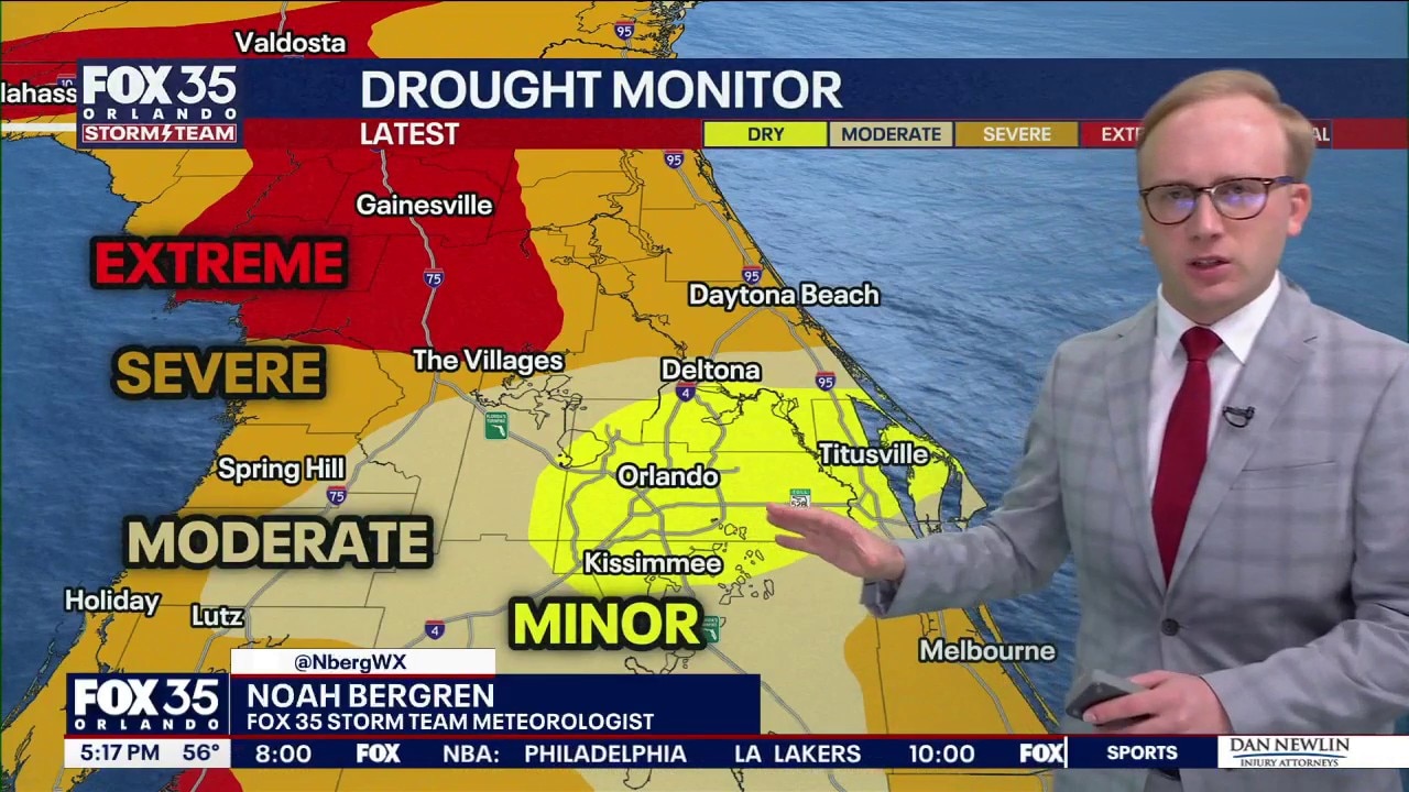
Orlando Weather Forecast: Extreme drought developing across Florida
FOX 35 Storm Team Senior Meteorologist Noah Bergren is tracking the worst drought in Florida since 2012 -- and colder air coming in tonight.
ORLANDO, Fla. - North Central Florida residents should prepare for one final blast of arctic air tonight before a massive shift in the weather pattern brings spring-like temperatures just in time for the Super Bowl and Valentine's Day.

The Immediate Forecast: A Brutal Morning Commute
After a gloomy Thursday, the clouds are clearing. While recent rains provided a small reprieve, they weren't enough to offset the drought conditions in the area.
The primary concern for Friday morning is the combination of freezing temperatures and gusty winds.
Freeze Warnings (3 a.m. to 9 a.m. Friday)
Areas: Alachua, Marion, and Gilchrist Counties
Temperatures: Expected to hit or dip below the 32°F mark.
Wind Chill: Northerly gusts up to 20 mph will make it feel like the mid-20s.
Cold Weather Advisories (1 a.m. to 9 a.m. Friday)
Areas: Remainder of the viewing area
Temperatures: Hovering near freezing in the mid-to-upper 30s.
Wind Chill: Lows will feel like the low 30s throughout the early morning.
The Weekend Outlook: The Warming Trend Begins
The good news is that Friday marks the beginning of a warming trend. Once the sun comes up, we can expect gorgeous sunny skies and high temperatures climbing back into the low 60s.
By Friday night, the extreme cold will have vanished, with overnight lows only bottoming out in the upper 40s—a nearly 20-degree improvement from the previous night.
Looking Ahead: A "Big Game" Heat Wave
If you’re tired of shivering, you're in luck. A giant ridge of high pressure is moving over the center of the country, triggering a huge pattern change.
Super Bowl Sunday (Feb 8): Perfect party weather is on tap with highs in the low 70s and abundant sunshine.
Valentine’s Day & Daytona 500 (Feb 14-15): The warming trend continues, with temperatures potentially flirting with 80°F.

An Eye on the Track
While the forecast remains dry for the next week, race organizers for the Daytona 500 are closely monitoring the potential for a cold front to bring rain just after the event. We will have a better idea of any potential race-day impacts as we head into this weekend.
The Source: This story was written with information from the FOX 35 Storm Team.