

Orlando weather: Dangerous heat, flooding risk return to Central Florida
ORLANDO, Fla. - On Wednesday, we now expect a brief lull in the afternoon rain and storm coverage as some drier air arrives up in the cloud level of the atmosphere.
High daily rain and storm chances return Thursday to the weekend across all of Central Florida.
Heat ratchets up
How hot will it get?:
There will be one of the higher heat index values of the summer on Wednesday across Central Florida, with 100–110°F heat index around Orlando and down to the Space Coast, and 110–120°F in areas like Flagler, Alachua, and Marion counties.

Know the symptoms of heat exhaustion and take care if spending prolonged periods of time outdoors. Stay hydrated and take plenty of breaks if you plan on spending a lot of time outdoors. The heat index will taper down some Thursday into the weekend.
Daily downpours and storms this week
Rounds of scattered to widespread showers and storms will continue for most of the work week.
An active setup will bring rounds of heavy rain, mainly after lunchtime this week. It won't be an all-day washout and not everyone will see the rain each day, but where it rains it will really pour.
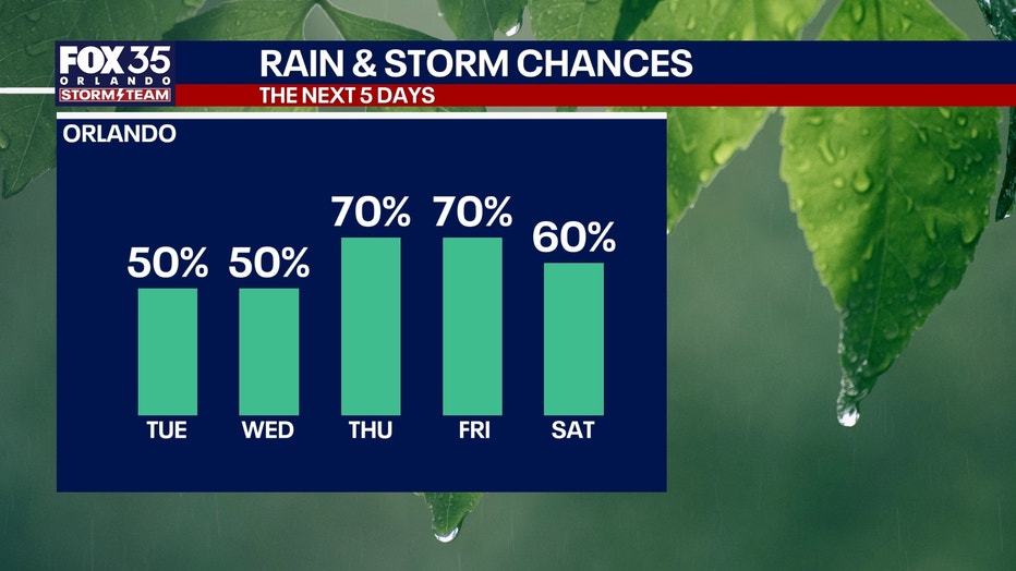
There will be some big downpours, which could produce localized flash flooding Thursday–Saturday — and because of this, the National Weather Service has outlined Central Florida as a risk for flooding as well.

Some places could get 5 or more inches of rain just between those three days this week.

Quiet in the Tropics
No tropical activity is expected over the next seven days.
But just because it's quiet doesn't mean we let our guard down.
It's important to stay prepared through the entire hurricane season and to check in with the FOX 35 Storm Team for the latest.
The Source: The information in this story was provided by the FOX 35 Storm Team.