

Orlando weather: Temps into the 90s, possible showers this weekend
Orlando PM Weather Forecast: 90 degree heat, rain incoming
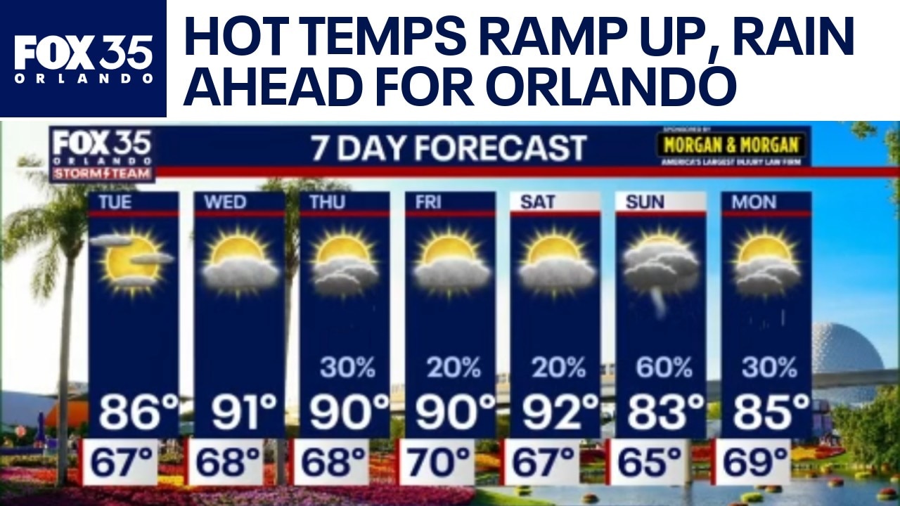
As temperature highs rise into the high 80s to low 90s this week, isolated showers hit parts of Osceola, Orange and Volusia counties.
ORLANDO, Fla. - As a cold front sweeps in to areas in the Midwest – Chicago, St. Louis – bringing a severe storm threat, areas in Central Florida were affected by isolated showers. Hitting areas in Orange, Osceola and Volusia counties, winds are bringing a strong breeze and increasing rip current risks in Daytona Beach.
Monday night: Clearing and milder
Any remaining shower activity is expected to fade throughout the evening as clouds clear into the overnight hours. This clearing trend will allow temperatures to vary across the region:

April 17, 2026 Weather
Northwest: Temperatures will dip into the upper 50s and lower 60s.
Orlando & Metro Areas: Expect starry conditions with milder temperatures in the middle to upper 60s.
Conditions: It will feel a bit muggier tonight, and residents in northwestern spots should look out for patchy fog.

April 17, 2026 Weather
Temperatures by city:
- Palm Coast: 64 degrees
- Daytona Beach: 67 degrees
- New Smyrna: 67 degrees
- Titusville: 67 degrees
- Clermont: 64 degrees
- Kissimmee: 66 degrees
- Winter Haven: 64 degrees
- St. Cloud: 65 degrees
- Sanford: 66 degrees
- Orlando: 67 degrees

April 17, 2026 Weather
Tuesday: The heat returns
A ridge of high pressure will quickly build back in on Tuesday, April 28, setting the stage for a drier and hotter midweek.
Highs: Most areas will top out in the middle to upper 80s, though far western neighborhoods could sneak up toward the low 90s.
Coastal Conditions: An onshore wind may trigger a rogue coastal shower or two, but most areas will remain dry.
Tuesday Night: Expect another warm, muggy night with lows in the middle to upper 60s.

April 17, 2026 Weather
Looking Ahead: 90s and Fire Concerns
The heat intensifies Wednesday through the latter half of the week, with highs jumping into the upper 80s and lower 90s. As dry air reaches the area and a heat dome builds mid-week, temperatures will approach the 90 degree mark quickly, FOX 35's TJ Springer reported.

April 17, 2026 Weather
A cold front may bring a few scattered showers on Thursday and Friday, though highs will remain above average in the lower 90s. As we head into next weekend, the front is expected to push back north as a warm front, potentially increasing chances for showers and storms.
The most significant weather shift arrives Sunday, as a stronger cold front moves in. This system brings a 60% chance of rain and storms—the best chance for moisture the region will see all week. Some lingering showers and storms may persist into early next week.
The Source: Information in this story was gathered from FOX 35's TJ Springer.