

Orlando Weather Alert: 3-day heat wave could bring record-breaking temperatures
Orlando weather: Excessive heat, storms ahead
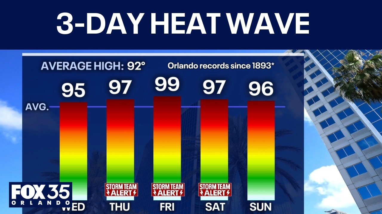
A three-day heat wave is ahead for Central Florida, with temperatures in the high 90s. Additionally, storms move toward Volusia County, focusing over Ponce Inlet, bringing an inch of rain over the past three hours.
ORLANDO, Fla. - Showers and storms are expected to linger through mid-evening, Tuesday, moving east toward I-95 along the Atlantic coast.
By Wednesday, storm chances will decrease slightly, but scattered activity is still expected by the afternoon.
A handful of storms should impact the area between 4 p.m. and 9 p.m. – which is occurring later in the day than previous trends seen this week. One or two of these storms may turn severe with potential high winds or hail.
FOX 35 Storm Team Alert: Thursday to Saturday
A large "heat dome" in the upper atmosphere will slide over Florida, acting to compress the atmosphere and heat things up a lot further than they are now. This will also help to dramatically lower afternoon/evening rain and storm chances for a few days.
However, due to this, temperatures will jump significantly starting Thursday to Saturday. Afternoon highs each day will be in the upper 90s inland and in the mid-90s on the beaches.
Record-breaking heat?
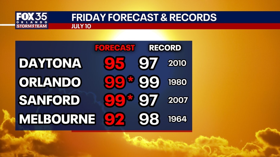
FOX 35 will be keeping an eye on potential record-breaking heat this week.
Many cities will either tie or break records inland with high temps between 96 and 99 degrees. The heat index will range between 105 and 112 degrees, depending on location during the afternoons.
This is excessive heat that can have a big impact on you if outdoors for a significant or prolonged period of time.
Records in Orlando:
Thursday, July 9: 98° (1931, 1932)
Friday, July 10: 99° (1980)
Saturday, July 11: 98° (1892, 1989)
Saharan dust to pass over Central Florida Wednesday into Thursday
The sky will look muted and filtered at times as a plume of Saharan Dust passes over the state. Saharan Dust blows off the coast of Africa every summer, and travels between 5,000 and 15,000 feet up in the atmosphere across the Atlantic Ocean. Some years the plume of dust makes it all the way to the southeast United States, other years it does not.
Read more: Massive Saharan dust cloud headed towards Florida this week
Saharan Dust acts to reduce tropical activity, heat the atmosphere up more, and provide abnormally vibrant sunrises and sunsets. That's because the dust suspended high up in the atmosphere can help to spread the light out making it more vibrant.
Occasionally, dust can reduce air quality for those in sensitive groups, but only sometimes.
Quietest start to Atlantic Hurricane season in 12+ years
With just Arthur in the Gulf so far, this is the calmest start to the Atlantic hurricane season since 2014.
- The average historical second named storm of the Atlantic hurricane season is July 17.
- The average first hurricane of the year is generally August 11.
- The average first major (Cat. 3+) hurricane is September 1.
The Source: Information in this story was gathered from FOX 35's Noah Bergren.