Orlando weather: Evening storms bring torrential rain, gusty winds and vivid lightning

Orlando PM Weather Forecast: Sept. 6, 2025
FOX 35 Storm Team Meteorologist Laurel Blanchard has our latest forecast. Showers and storms linger through the rest of the evening and ignite once again for our Sunday as our weather pattern remains unsettled. Tune in for the timeline so you can plan out the rest of your weekend.
ORLANDO, Fla. - What started off as a beautiful weather day across Central Florida has now turned into scattered showers and thunderstorms expected through the evening.
Here's a look at the main weather impacts, as well as when the rain is expected to arrive and how long it'll last.
What will the weather look like tonight?
What To Expect:
A boundary draped across Central Florida will sit over the region through the rest of the weekend, and a low pressure system will continue to linger.
This will bring scattered showers and thunderstorms through the rest of Saturday.
CLICK TO DOWNLOAD THE FOX LOCAL APP
With this boundary and the sea breezes colliding, the worst of the rain will linger through the evening and taper off through the overnight.
Torrential rain is the main threat from the storms, followed by gusty winds and vivid lightning.

The skies will clear with a few lingering clouds tonight, and temperatures will bottom out in the mid-70s.
What will the weather look like tomorrow?
What's next:
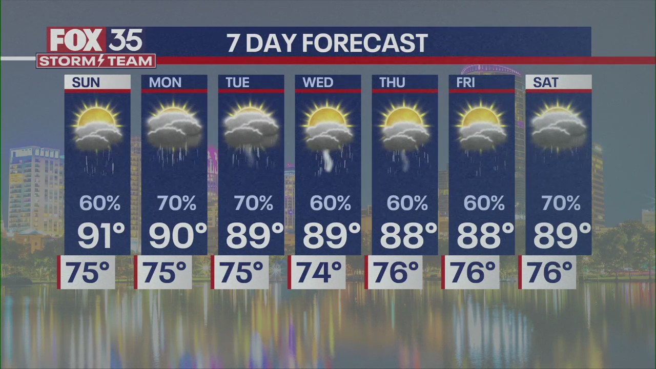
As the low pressure and boundary linger over Central Florida, conditions will stay unsettled through the rest of the weekend, but it won't be a total washout.
Sunday morning looks good, but as the day heats up we will be seeing more storms on Sunday afternoon and through the evening.

Torrential rain is the main threat, followed by gusty winds and vivid lightning.
Temperatures tomorrow morning will heat up quickly before the clouds and the storms pick up in the afternoon. So, if you are coming out to Icon Park tomorrow for Ultimate Tailgate, tomorrow morning looks to be the best time to come visit and hang out with the whole FOX 35 News crew!

What will the weather look like next week?
Looking ahead:
Another disturbance will push an additional wave of moisture into the region Monday into Tuesday, keeping our rain chances on the higher end to start off the work week.
With another boundary looking to stall over Florida, the more widespread storms will continue through the middle of the workweek.

The days won't be total washouts, but there will be storms that most likely everyone will see at some point during the day until about mid-week.
SIGN-UP FOR FOX 35'S BREAKING NEWS, DAILY NEWS NEWSLETTERS
We will see some cooler air tap into the region though, dropping highs into the upper-80s by the end of the workweek.

FOX 35 Storm Tracker Radar and Live Weather Cameras
Track live when storms move across your area using the FOX 35 Storm Tracker Radar below. You can also watch as heavy rain moves across Central Florida on our Live Weather Cameras' page here.
The Source: This story was written based on information shared by the FOX 35 Storm Team on Sept. 6, 2025.


