

Orlando weather: Wednesday brings another chance of afternoon, evening storms

Orlando Weather Forecast PM: May 27, 2025
FOX 35 meteorologist Noah Bergren has a look at the evening weather forecast for May 27, 2025.
ORLANDO, Fla. - Scattered thunderstorms that blew up along the Interstate 4 corridor on Tuesday evening will taper off.
What will the weather look like tonight?
What to expect:
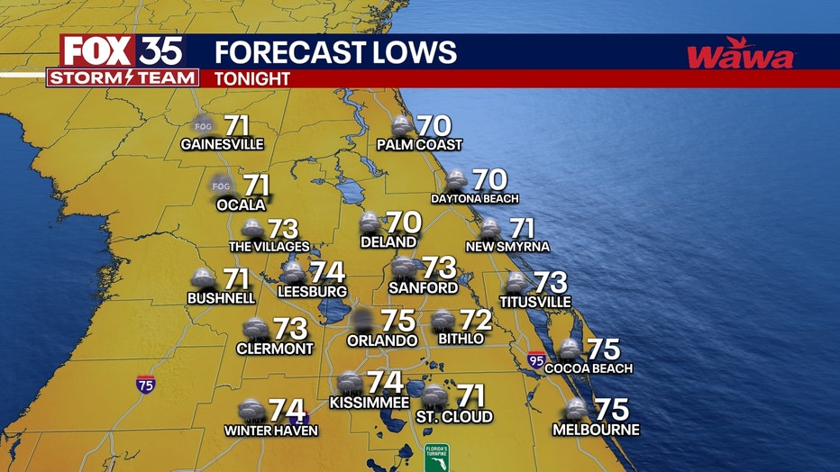
Overnight temperatures will fall into the mid-70s.
What will the weather look like on Wednesday?
What to Expected:
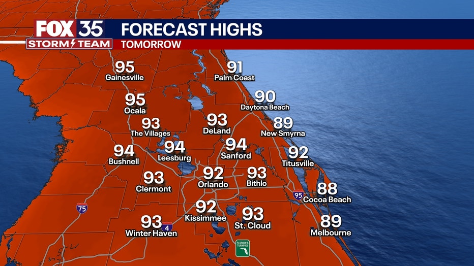
A mix of clouds and sunshine will dominate the day, with inland highs ranging from 90 to 95 degrees. Heat index values may climb near 100. Storms are likely to develop during the afternoon and evening hours, pushing east toward the Interstate 95 corridor. A few storms could be strong.
What will the weather look like for the remainder of the week?
Looking ahead:
Rain and storm chances remain high Thursday and Friday, with widespread scattered showers and thunderstorms expected. A rare late-May cold front is forecast to move through Florida and the southeastern United States Friday night into Saturday morning.
Behind the front, humidity and cloud cover will quickly drop by Saturday morning. The afternoon will be bright and sunny, with conditions more typical of October or November.
Sunday is expected to remain dry for much of the state, with rain chances limited to South Florida and the Florida Keys.
Heat, humidity and storm chances will return early next week.
Hurricane season officially begins Sunday, June 1.
Orlando 7-Day Weather Forecast

FOX 35 Storm Tracker Radar
Track live when storms move across your area using the FOX 35 Storm Tracker Radar below.

More radar maps from FOX 35 Storm Tracker Radar
- Brevard County
- Flagler County
- Lake County
- Marion County
- Osceola County
- Orange County
- Polk County
- Seminole County
- Sumter County
- Volusia County
- U.S./National Radar
STAY CONNECTED WITH FOX 35 ORLANDO:
- Download the FOX Local app for breaking news alerts, the latest news headlines
- Download the FOX 35 Storm Team Weather app for weather alerts & radar
- Sign up for FOX 35's daily newsletter for the latest morning headlines
- FOX Local: Stream FOX 35 newscasts, FOX 35 News+, Central Florida Eats on your smart TV
The Source: This story was written based on information shared by the FOX 35 Storm Team on May 27, 2025.