

Orlando weather: Hazy evening with a few splash-and-dash storms

Orlando PM Weather Forecast: June 7, 2025.
It was a great start of the weekend and we will see a sunny rest of the weekend. Seeing less humidity and mostly sunny skies on tap for your Sunday. FOX 35 Meteorologist Laurel Blanchard has a look at the rest of your weekend and when the rain makes its way back into the forecast.
ORLANDO, Fla. - Although Saturday's weather has so far brought mostly clear skies, we are in store for a hazy evening with a few splash-and-dash storms across Central Florida.
What will the weather look like tonight?
What To Expect:
Saturday's weather brought mostly clear skies across Central Florida.
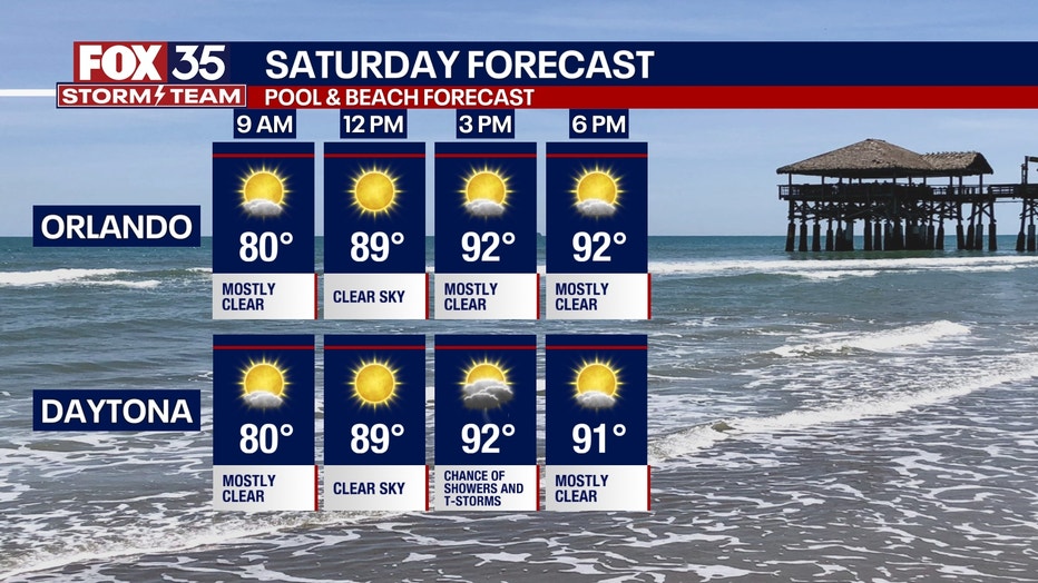
We are in store for a hazy evening with a few splash-and-dash storms. However, the storms will dissipate after 9 p.m. with conditions staying warm and muggy through the overnight.
This evening we should be in for a STUNNING sunset with fewer clouds and the Saharan dust still lingering in the atmosphere.
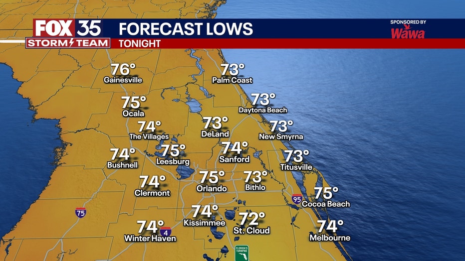
Temperature lows for overnight will be in the low-to-mid-70s with mainly clear skies.
What will the weather look like tomorrow?
What's next:
Take the forecast we had today, and copy and paste for Sunday.
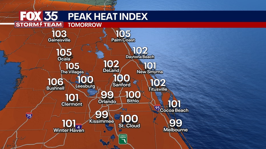
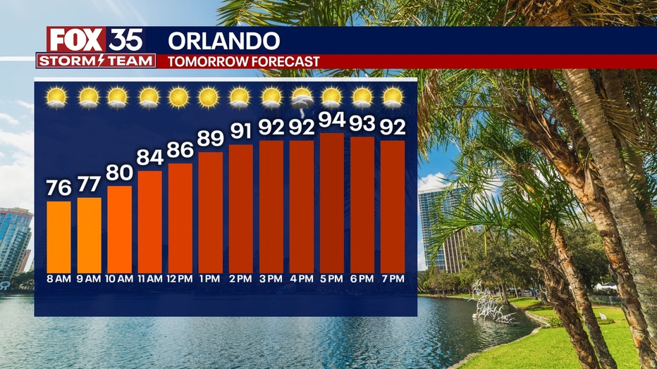
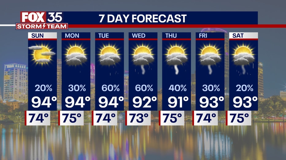
Temperatures in the low-to-mid-90s are on tap for your Sunday with only a 20% chance of a few evening thunderstorms scattered across the region.
It will be a great weekend to spend at the pool or at the beach. The humidity will be lower tomorrow, so conditions will feel more pleasant before the humidity comes back next week. Make sure you get outside and enjoy it!
Any chance of clouds or pop-up showers that spark up in the afternoon will quickly fizzle out.
Overnight, the clouds will clear, and the temperatures will fall in the low-70s.
What will the weather look like next week?
Dig deeper:
Next week, we fall right back into the daily widespread afternoon storms.
It looks like the chances of rain are 60% or higher starting next Tuesday.
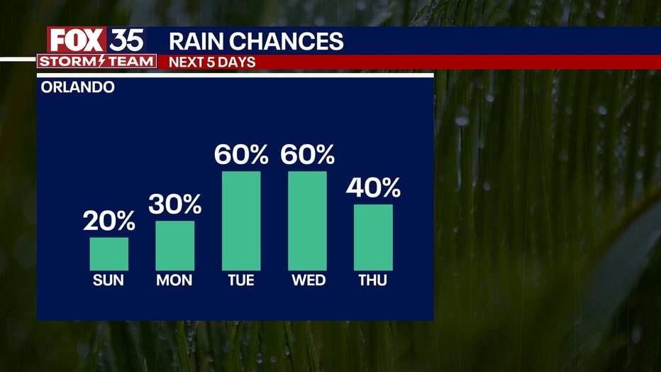
Highs will be in the low-and-mid-90s for most of next week. The humidity also jumps up, making it feel hotter than 100 degrees.
We will keep this pattern through next weekend.
The tropics remain quiet, and should stay quiet, for a while in the Atlantic basin due to the dust and high wind shear currently in the atmosphere.
FOX 35 Storm Tracker Radar and Live Weather Cameras
Track live when storms move across your area using the FOX 35 Storm Tracker Radar below. You can also watch as heavy rain moves across Central Florida on our Live Weather Cameras' page here.

More radar maps from FOX 35 Storm Tracker Radar
- Brevard County
- Flagler County
- Lake County
- Marion County
- Osceola County
- Orange County
- Polk County
- Seminole County
- Sumter County
- Volusia County
- U.S./National Radar
STAY CONNECTED WITH FOX 35 ORLANDO:
- Download the FOX Local app for breaking news alerts, the latest news headlines
- Download the FOX 35 Storm Team Weather app for weather alerts & radar
- Sign up for FOX 35's daily newsletter for the latest morning headlines
- FOX Local: Stream FOX 35 newscasts, FOX 35 News+, Central Florida Eats on your smart TV
The Source: This story was written based on information shared by the FOX 35 Storm Team on June 7, 2025.