

Orlando weather: Strong storms, Saharan dust and high rain chances through weekend
What will the weather look like tonight?
What To Expect:
ORLANDO, Fla. - WEATHER IMPACT DAY: Today is a FOX 35 Weather Impact day for the risk of a few strong afternoon storms across Central Florida the rest of the afternoon and evening.
Most of the region is in the Marginal Level 1 out of 5 risk of seeing severe weather, so there is the possibility of seeing a stronger storm or two later on.
Not everyone will see rain and it certainly won't be a total washout for your Thursday afternoon and evening.
Storms will continue to pick up and with the most widespread storm between 4-6 PM when the morning commute is taking place. Today storms will be shifting west and eventually move off the West Coast.
Main threats, especially with the stronger storms that fire up: wind gusts of up to 60 mph+, frequent lightning, pockets of hail, and heavy downpours.
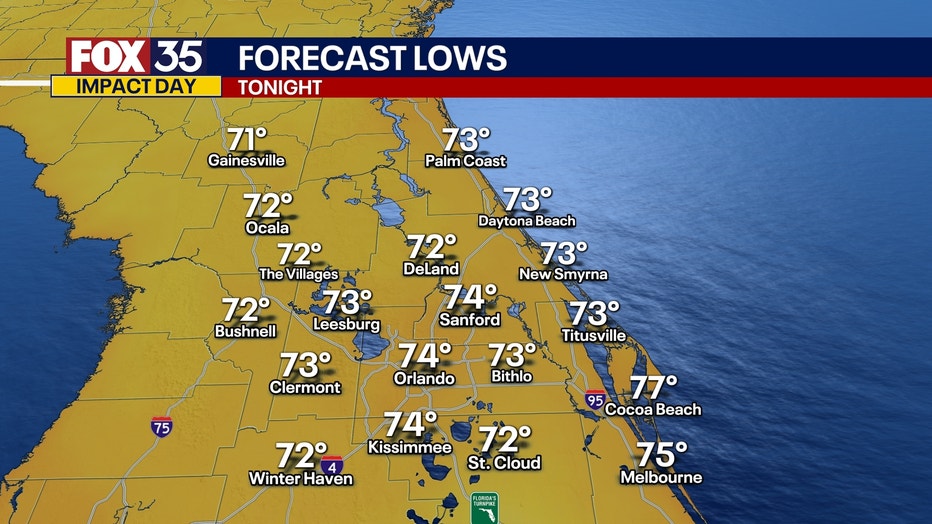
Storms quiet down tonight leaving partly cloudy skies and mild and muggy conditions. Lows drop tonight into the low and mid 70s tonight.
What will the weather look like tomorrow?
What's next:
WEATHER IMPACT DAY: Today is a FOX 35 Weather Impact day for the risk of a few strong afternoon storms across Central Florida in the afternoon and evening.
We will see more storms across the region Friday afternoon with the entire region being under a Marginal Level 1 out of 5 risk of seeing severe weather.
Storms will start to pick up between 1 and 2 PM with the most widespread storms from 5-6PM. Storms on Friday will move east, so areas along the east coast beaches, keep an eye to the skies and if you hear thunder, leave the beach immediately and find shelter.
Main threats, especially with the stronger storms that fire up: wind gusts of up to 60 mph+, frequent lightning, pockets of hail, and heavy downpours.
What will the weather look like this weekend?
Dig deeper:
The storms stick around as unsettled weather continues into the weekend.
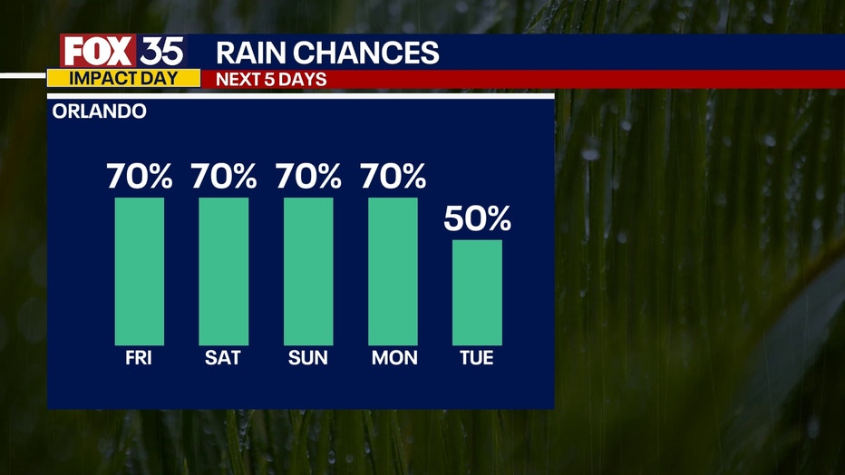
There is an upper level low pressure system that will usher in storms and keep the rain chances and humidity high over the next few days. Rain chances stay 50-70% through early next week.
The Saharan Dust also returns for the weekend, so heads up for those who have allergies, you may be feeling it the next few days. This will lower the air quality just a bit and make the skies look milky before storms pop up. With this dry layer this will also increase the possibility of lightning when storms do arise. However, this will keep the tropics quiet through the end of June.
FOX 35 Storm Tracker Radar and Live Weather Cameras
Track live when storms move across your area using the FOX 35 Storm Tracker Radar below. You can also watch as heavy rain moves across Central Florida on our Live Weather Cameras' page here.

More radar maps from FOX 35 Storm Tracker Radar
- Brevard County
- Flagler County
- Lake County
- Marion County
- Osceola County
- Orange County
- Polk County
- Seminole County
- Sumter County
- Volusia County
- U.S./National Radar
STAY CONNECTED WITH FOX 35 ORLANDO:
- Download the FOX 35 News app for breaking news alerts, the latest news headlines
- Download the FOX 35 Storm Team Weather app for weather alerts & radar
- Sign up for FOX 35's daily newsletter for the latest morning headlines
- FOX Local: Stream FOX 35 newscasts, FOX 35 News+, Central Florida Eats on your smart TV
The Source: This story was written based on information shared by the FOX 35 Storm Team on June 26, 2025.